Thursday, January 31, 2013

Impact Melt in Raditladi Basin


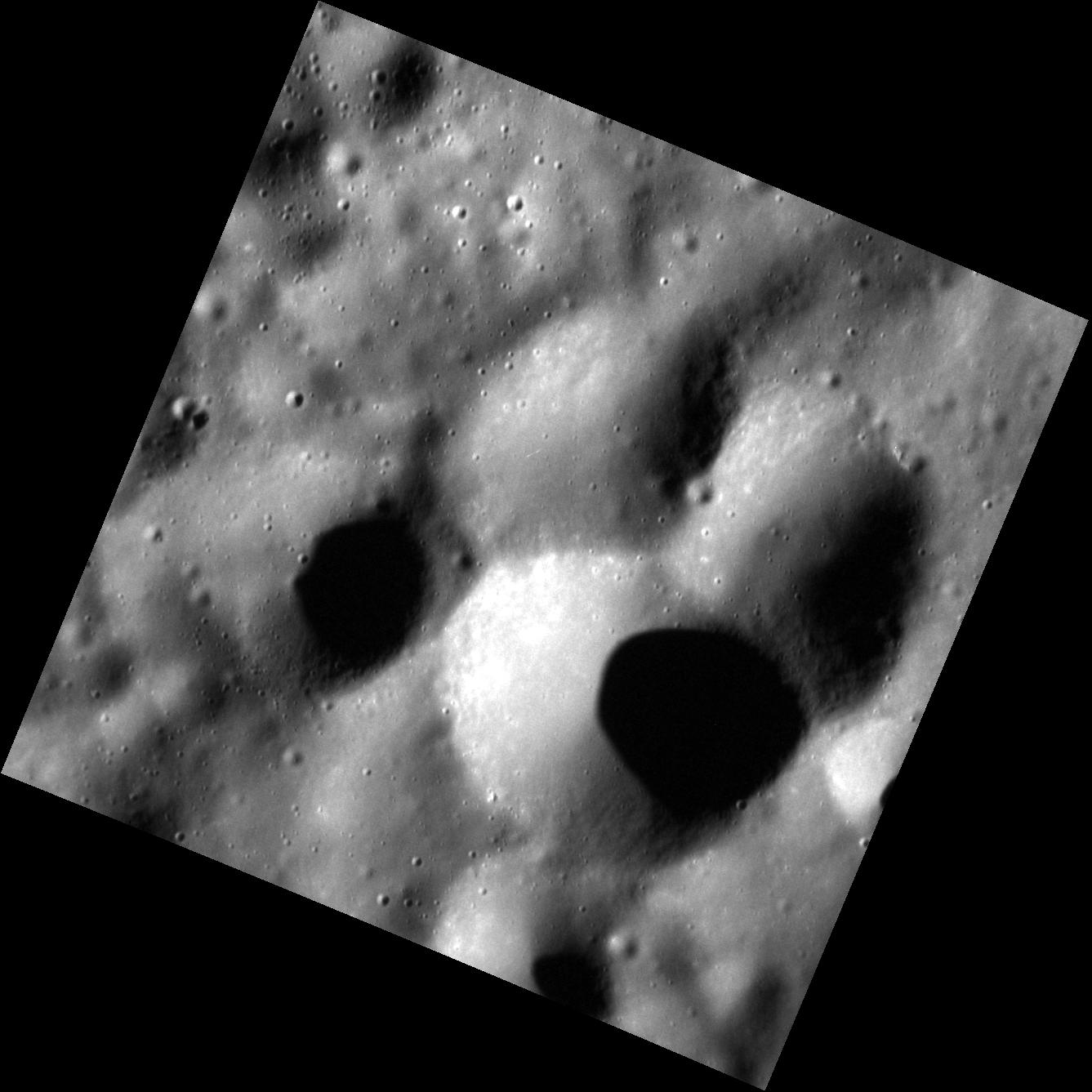
We have seen the ejecta deposit of the Raditladi basin before, but not at this resolution. Here, the smooth patches of surface are solidified ponds of impact melt, rock liquefied by the tremendous heat of the impact explosion that formed Raditladi. The rougher, higher-standing terrain is either solid ejecta deposited around the impact site, or part of the original surface that predates the basin's formation.

Date acquired: November 19, 2012
Image Mission Elapsed Time (MET): 261770877
Image ID: 2981602
Instrument: Narrow Angle Camera (NAC) of the Mercury Dual Imaging System (MDIS)
Center Latitude: 29.06°
Center Longitude: 115.13° E
Resolution: 27 meters/pixel
Scale: The field of view is ~25 km (16 mi.) from top to bottom
Incidence Angle: 68.0°
Emission Angle: 27.4°
Phase Angle: 95.4°
North is to the bottom of this image.

Photo credit: NASA/Johns Hopkins University Applied Physics Laboratory/Carnegie Institution of Washington

Wednesday, January 30, 2013

Counting Craters


Counting craters on Mercury is a serious job, as the density of craters on the surface of a planet can be used to indicate its age; the more craters present, the older the surface. Although this technique is commonly used on planetary bodies throughout the Solar System, crater counting on Mercury is particularly challenging. Secondary craters are formed by debris thrown out during an impact, and are often big enough to be confused with primary craters. Their inclusion in crater-counting studies, however, would skew derived age results for a surface, making it appear older than it really is, and so care must be taken when deciding which craters to count, and which to leave out.

Date acquired: November 05, 2012
Image Mission Elapsed Time (MET): 260592647
Image ID: 2897484
Instrument: Narrow Angle Camera (NAC) of the Mercury Dual Imaging System (MDIS)
Center Latitude: -37.74°
Center Longitude: 194.02° E
Resolution: 117 meters/pixel
Scale: The crater just left of upper center is ~20 km (12 mi.) in diameter
Incidence Angle: 37.9°
Emission Angle: 4.6°
Phase Angle: 38.7°
North is to the right of this image

Photo credit: NASA/Johns Hopkins University Applied Physics Laboratory/Carnegie Institution of Washington

Tuesday, January 29, 2013

Crater Cliff


The floor of the Caloris basin consists of smooth, volcanic plains -- but these plains have been modified by subsequent impacts and tectonic deformation. This crater, which is located not only on the Caloris interior plains but half-covers its neighbor, has a sharp, well-preserved rim and internal terraces. The floor of the crater is some 900 m (~0.5 mi.) below the rim, making this crater's wall quite a cliff indeed.

Date acquired: November 08, 2012
Image Mission Elapsed Time (MET): 260906527
Image ID: 1222306
Instrument: Narrow Angle Camera (NAC) of the Mercury Dual Imaging System (MDIS)
Center Latitude: 29.31°
Center Longitude: 91.0° E
Resolution: 21 meters/pixel
Scale: The field of view is ~20 km (12 mi.) across
Incidence Angle: 40.1°
Emission Angle: 8.5°
Phase Angle: 48.7°
North is to the right of this image.

Photo credit: NASA/Johns Hopkins University Applied Physics Laboratory/Carnegie Institution of Washington

Saturday, January 26, 2013

Kertesz Crater


This spectacular image is a mosaic of three separate NAC frames. It gives us a close-up look at the enigmatic Kertesz crater and its extensive system of hollows.

Date acquired: January 11, 2013
Image Mission Elapsed Time (MET) Since 8 January, 2013: 187422, 187426, 187430
Image ID: 3307043, 3307044, 3307045
Instrument: Narrow Angle Camera (NAC) of the Mercury Dual Imaging System (MDIS)
Center Latitude: 27.38°
Center Longitude: 146.3° E
Resolution: 30 meters/pixel
Scale: Kertesz crater is approximately 31 km (19 mi.) in diameter.
Incidence Angle: 80.5°
Emission Angle: 16.2°
Phase Angle: 64.3°

Photo credit: NASA/Johns Hopkins University Applied Physics Laboratory/Carnegie Institution of Washington

Friday, January 25, 2013

Michelangelo Impact Basin


Here, the peak-ringed Michelangelo basin is seen close to the terminator. Hawthorne crater (outside this image field of view past the upper right corner) may be the source of the secondary crater chains that cross through the basin. North is towards the bottom of this image.

Date acquired: March 26, 2012
Image Mission Elapsed Time (MET): 241236952
Image ID: 1566240
Instrument: Narrow Angle Camera (NAC) of the Mercury Dual Imaging System (MDIS)
Center Latitude: -44.13°
Center Longitude: 251.5° E
Resolution: 369 meters/pixel
Scale: Michelangelo basin is approximately 230 km (143 mi.) in diameter.
Incidence Angle: 83.6°
Emission Angle: 37.6°
Phase Angle: 67.5°

Photo credit: NASA/Johns Hopkins University Applied Physics Laboratory/Carnegie Institution of Washington

Thursday, January 24, 2013

Grainger Crater


Grainger crater, seen at the bottom of this image, exhibits a tall central peak and interesting color features, including low-reflectance material and hollows. Grainger crater was named in 2012 for Australian composer, arranger, and pianist Percy Grainger (1882-1961), many of whose compositions are considered standards of the wind symphony/military band genre.

Date acquired: January 30, 2012
Image Mission Elapsed Time (MET): 236408235
Image ID: 1330758
Instrument: Narrow Angle Camera (NAC) of the Mercury Dual Imaging System (MDIS)
Center Latitude: -42.90°
Center Longitude: 105.3° E
Resolution: 119 meters/pixel
Scale: Grainger crater is approximately 113 km (70 mi.) in diameter.
Incidence Angle: 65.3°
Emission Angle: 16.7°
Phase Angle: 81.7°

Photo credit: NASA/Johns Hopkins University Applied Physics Laboratory/Carnegie Institution of Washington

Wednesday, January 23, 2013

Disney Crater


MESSENGER went viral in 2012 when it spotted Mickey Mouse on Mercury! The largest of this coincidental collection of craters (Mickey's head), seen towards the top of this image, was recently named in honor of American film maker, actor, animator Walt Disney (1901-1966). North is down in this image.

Date acquired: July 20, 2011
Image Mission Elapsed Time (MET): 219617891
Image ID: 525880
Instrument: Narrow Angle Camera (NAC) of the Mercury Dual Imaging System (MDIS)
Center Latitude: -66.68°
Center Longitude: 101.7° E
Resolution: 309 meters/pixel
Scale: Disney crater is approximately 113 km (70 mi.) in diameter.
Incidence Angle: 66.9°
Emission Angle: 33.6°
Phase Angle: 100.6°

Photo credit: NASA/Johns Hopkins University Applied Physics Laboratory/Carnegie Institution of Washington

Tuesday, January 22, 2013

Ellington Basin and Berkel Crater


Ellington basin, named in 2012 for American jazz legend Duke Ellington (1899-1974), is a peak ring basin covered in secondary craters. The prominent crater Berkel lies inside of the basin. Berkel's ejecta and floor exhibit differences in reflectance and color, indicating a heterogeneous local stratigraphy. This image was created by merging a color image with a monochrome image, in order to emphasize both the topography and the color of the area.

Date acquired: August 07, 2012
Image Mission Elapsed Time (MET): 252814064, 252814056, 252814060
Image ID: 2344652, 2344650, 2344651
Instrument: Wide Angle Camera (WAC) of the Mercury Dual Imaging System (MDIS)
WAC filters: 9, 7, 6 (996, 748, 433 nanometers) in red, green, and blue
Center Latitude: -14.85°
Center Longitude: 25.55° E
Resolution: 476 meters/pixel
Scale: Ellington basin is 216 km (134 mi.) in diameter.
Incidence Angle: 19.3°
Emission Angle: 8.7°
Phase Angle: 28.0°

Photo credit: NASA/Johns Hopkins University Applied Physics Laboratory/Carnegie Institution of Washington

Saturday, January 19, 2013

Poe Crater


For as long as 70 years, a visitor to the original grave site of Edgar Allan Poe left a tribute in the form of roses and a bottle of cognac each January 19 (Poe's birthday). The "Poe Toaster" has not appeared since 2009, and it appears that the tradition has ended. Here we offer our own toast to the great American writer: a color view of Poe crater on Mercury. In this representation, Poe's raven-colored rim stands out from the tan volcanic plains that surround it. Tiny hollows speckle the dark rim like blue-white stars in the blackness of night. This sinfully scintillant planet/From the Hell of the planetary souls.

Date acquired: July 03, 2011
Image Mission Elapsed Time (MET): 218204194, 218204190, 218204186
Image ID: 458399, 458398, 458397
Instrument: Wide Angle Camera (WAC) of the Mercury Dual Imaging System (MDIS)
WAC filters: 9, 7, 6 (996, 748, 433 nanometers) in red, green, and blue.
Center Latitude: 42.83°
Center Longitude: 158.9° E
Resolution: 213 meters/pixel
Scale: Poe crater is about 77 km (48 mi.) in diameter.
Incidence Angle: 42.8°
Emission Angle: 35.9°
Phase Angle: 78.7°

Photo credit: NASA/Johns Hopkins University Applied Physics Laboratory/Carnegie Institution of Washington

Friday, January 18, 2013

Young Impact Crater


This image, taken with the Narrow Angle Camera (NAC), shows an unnamed complex crater in Mercury's southern hemisphere. The sharpness of the terraced walls and central peaks indicate that the crater is relatively young. Also visible is a secondary crater chain that crosses the northern half of the crater floor, most likely created by the ejecta of an impact outside of the field of view.

Date acquired: December 17, 2012
Image Mission Elapsed Time (MET): 264215266
Image ID: 3155492
Instrument: Narrow Angle Camera (NAC) of the Mercury Dual Imaging System (MDIS)
Center Latitude: -23.01°
Center Longitude: 112.1° E
Resolution: 205 meters/pixel
Scale: This crater is about 75 km (47 mi.) in diameter.
Incidence Angle: 41.0°
Emission Angle: 1.6°
Phase Angle: 39.4°

Photo credit: NASA/Johns Hopkins University Applied Physics Laboratory/Carnegie Institution of Washington

Wednesday, January 16, 2013

Cloverleaf Craters


This very high resolution image features three impact craters of nearly the same size that overlap to form a cloverleaf pattern. All three have rounded rims, indicating that they are relatively old. Determining the sequence of events is difficult. It may be that the one at the bottom formed most recently, blasting away sections of the rims of the other two.

Date acquired: February 26, 2012
Image Mission Elapsed Time (MET): 238781474
Image ID: 1445431
Instrument: Narrow Angle Camera (NAC) of the Mercury Dual Imaging System (MDIS)
Center Latitude: 48.76°
Center Longitude: 298.0° E
Resolution: 13 meters/pixel
Scale: The scene is about 14 km (9 mi.) across.
Incidence Angle: 71.7°
Emission Angle: 0.1°
Phase Angle: 71.7°

Photo credit: NASA/Johns Hopkins University Applied Physics Laboratory/Carnegie Institution of Washington

Tuesday, January 15, 2013

Raditladi Basin


This image, taken with the Wide Angle Camera (WAC), shows the outer rim and inner peak ring of Raditladi basin. The basin's smooth floor and well-preserved peak ring structure indicate that Raditladi is relatively young. The concentric troughs along the floor near the basin's center formed by extension (pulling apart) of the surface and are similar to those seen in Caloris basin and Rembrandt basin. The bright areas around the peak ring are an excellent example of hollows, shallow depressions that may have been formed by the loss of volatile materials.

Date acquired: December 17, 2012
Image Mission Elapsed Time (MET): 264246178
Image ID: 3157599
Instrument: Wide Angle Camera (WAC) of the Mercury Dual Imaging System (MDIS)
WAC filter: 7 (748 nanometers)
Center Latitude: 26.29°
Center Longitude: 119.1° E
Resolution: 228 meters/pixel
Scale: Raditladi basin has a diameter of 257 kilometers (160 miles)
Incidence Angle: 36.9°
Emission Angle: 9.0°
Phase Angle: 45.9°

Photo credit: NASA/Johns Hopkins University Applied Physics Laboratory/Carnegie Institution of Washington

Monday, January 14, 2013

Mendelssohn Impact Basin Rim


This image shows a southern portion of the Mendelssohn impact basin. The smooth plains in the top (north) half of the image contrast sharply with the rugged, heavily cratered geological unit that forms the basin rim. The smooth plains were formed by eruption of highly fluid lavas that covered the basin floor. The Sun was low on the horizon when the image was captured, and the resulting shadows reveal the presence of ridges in the plains that mark the rims of impact craters buried by the lavas.

Date acquired: December 05, 2011
Image Mission Elapsed Time (MET): 231567383
Image ID: 1097256
Instrument: Wide Angle Camera (WAC) of the Mercury Dual Imaging System (MDIS)
WAC filter: 7 (748 nanometers)
Center Latitude: 67.16°
Center Longitude: 99.57° E
Resolution: 95 meters/pixel
Scale: The scene is about 124 km (77 mi.) across.
Incidence Angle: 86.3°
Emission Angle: 37.5°
Phase Angle: 123.9°

Photo credit: NASA/Johns Hopkins University Applied Physics Laboratory/Carnegie Institution of Washington

Sunday, January 13, 2013

Ray Systems East of Bronte Crater


Today's image shows a complicated area of rays to the east of crater Bronte (named for sisters Charlotte, Emily, and Anne Bronte, and their brother Branwell). The rays trending roughly northeast-southwest originated from Degas, which formed just touching Bronte's rim. The roughly north-south ray (and secondary crater chain) on the right side of the image was probably formed by ejecta that came over the pole from Hokusai.

Date acquired: April 22, 2011
Image Mission Elapsed Time (MET): 211981114
Image ID: 163497
Instrument: Wide Angle Camera (WAC) of the Mercury Dual Imaging System (MDIS)
WAC filter: 7 (748 nanometers)
Center Latitude: 38.15°
Center Longitude: 238.4° E
Resolution: 322 meters/pixel
Scale: The edges of the image are about 330 km (205 mi.) long.
Incidence Angle: 62.4°
Emission Angle: 0.2°
Phase Angle: 62.5°

Photo credit: NASA/Johns Hopkins University Applied Physics Laboratory/Carnegie Institution of Washington

Saturday, January 12, 2013

Southern Caloris Basin Ring of Fire


Here is a color view of the southern part of the Caloris basin. Extending along the southern rim are a number of pyroclastic deposits that have a distinctive reddish color. The inset locator map shows the entire Caloris basin; the red dots correspond to mapped pyroclastic deposits, which formed during explosive volcanic eruptions. On the Earth, volcanoes are often associated with boundaries where tectonic plates interact. The Pacific "Ring of Fire" is a famous example of volcanism found at plate boundaries. Mercury, by contrast, is a one-plate planet. Instead, Mercurian volcanism is largely controlled by fracturing or tectonic features related to impact basins and craters. Caloris's southern rim is a partial "ring of fire."

This image is part of MDIS's high-resolution 3-color mosaic. The 3-color campaign is a major mapping activity in MESSENGER's extended mission. It complements the 8-color base map (at an average resolution of 1 km/pixel) acquired during MESSENGER's primary mission by imaging Mercury's surface in a subset of the color filters at the highest resolution possible. The three narrow-band color filters are centered at wavelengths of 430 nm, 750 nm, and 1000 nm, and image resolutions generally range from 100 to 400 meters/pixel in the northern hemisphere. The inset is part of Fig. 4 of L. Kerber et al., (2011), Planet. Space Sci. 59, 1895-1909.

Instrument: Wide Angle Camera (WAC) of the Mercury Dual Imaging System (MDIS)
WAC filter: 9, 7, 6 (1000, 750, 430 nanometers) in red, green, and blue.
Center Latitude: 22.8°
Center Longitude: 156.9° E
Resolution: 1000 meters/pixel
Scale: Atget, the dark-floored crater near the right edge, is 100 km (62 mi.) in diameter.

Photo credit: NASA/Johns Hopkins University Applied Physics Laboratory/Carnegie Institution of Washington0

Friday, January 11, 2013

New Blue Impact Crater


In the lower left portion of today's image is a small, young, rayed impact crater. The rays have a typical bluish cast in this color presentation. The relatively blue color in this case is caused partly by the extreme youth of the rays (surfaces exposed to the space environment of Mercury for long periods tend to "redden" and darken). In addition, the crater formed in a dark, bluish terrain called the "Low Reflectance Material." The tan area toward the top of the image is "intermediate terrain."

Date acquired: November 30, 2011
Image Mission Elapsed Time (MET): 231181189, 231181209, 231181193
Image ID: 1078917, 1078922, 1078918
Instrument: Wide Angle Camera (WAC) of the Mercury Dual Imaging System (MDIS)
WAC filters: 9, 7, 6 (996, 748, 433 nanometers) in red, green, and blue.
Center Latitude: -34.19°
Center Longitude: 133.6° E
Resolution: 647 meters/pixel
Scale: The small rayed crater is about 16 km (10 mi.) in diameter.
Incidence Angle: 54.9°
Emission Angle: 3.9°
Phase Angle: 58.7°

Photo credit: NASA/Johns Hopkins University Applied Physics Laboratory/Carnegie Institution of Washington