skip to main |
skip to sidebar

Fresh and bright, this unnamed, elongated crater appears to have been formed by an impactor that struck the surface at an oblique angle, causing most of the ejecta to be thrown out unevenly around the crater (notice the bright rays above, below, and to the right of the crater). The marginally bright material in the bottom left corner is actually part of a ray from Hokusai, over 1380 km (about 860 mi.) away!
This image was acquired as a high-resolution targeted color observation. Targeted color observations are images of a small area on Mercury's surface at resolutions higher than the 1-kilometer/pixel 8-color base map. During MESSENGER's one-year primary mission, hundreds of targeted color observations were obtained. During MESSENGER's extended mission, high-resolution targeted color observations are more rare, as the 3-color base map covered Mercury's northern hemisphere with the highest-resolution color images that are possible.
Date acquired: August 19, 2011
Image Mission Elapsed Time (MET): 222275999, 222275995, 222275991
Image ID: 652862, 652861, 652860
Instrument: Wide Angle Camera (WAC) of the Mercury Dual Imaging System (MDIS)
WAC filters: 9, 7, 6 (996, 748, 433 nanometers) in red, green, and blue
Center Latitude: 27.84°
Center Longitude: 30.73° E
Resolution: 116 meters/pixel
Scale: The small bright crater measures about 13 km (8 mi.) in long dimension.
Incidence Angle: 31.1°
Emission Angle: 37.2°
Phase Angle: 68.3°
Photo credit: NASA/Johns Hopkins University Applied Physics Laboratory/Carnegie Institution of Washington

Located in Copland crater, this image consists of three small unnamed impact craters and a contractional ridge that was partly destroyed by the two superimposed impact craters at the center. At one point extensive volcanic eruptions took place within Copland, forming a smooth surface. As the lava cooled it contracted, causing fractures and ridges to form. Images such as this give scientists a better understanding of the processes that accompany flood volcanism on Mercury and other planetary bodies.
This image was acquired as a high-resolution targeted observation. Targeted observations are images of a small area on Mercury's surface at resolutions much higher than the 200-meter/pixel morphology base map. It is not possible to cover all of Mercury's surface at this high resolution, but typically several areas of high scientific interest are imaged in this mode each week.
Date acquired: September 13, 2011
Image Mission Elapsed Time (MET): 224423780
Image ID: 755249
Instrument: Narrow Angle Camera (NAC) of the Mercury Dual Imaging System (MDIS)
Center Latitude: 38.00°
Center Longitude: 72.66° E
Resolution: 35 meters/pixel
Scale: The largest crater is about 9 km (5.5 mi.) in diameter.
Incidence Angle: 75.9°
Emission Angle: 0.2°
Phase Angle: 75.7°
Photo credit: NASA/Johns Hopkins University Applied Physics Laboratory/Carnegie Institution of Washington

Heine, detailed here, exhibits Low Reflectance Material (LRM) and high reflectance rays to the west of the crater. The LRM (darker area to the bottom) is likely darker, older material found in some southern areas on Mercury. The bright rays emanate from Degas, located approximately 150 km to the north. Heinrich Heine (1797-1856) is considered one of the most significant German poets of the 19th century. One of Heine's best known poems is "Die Lorelei."
This image was acquired as part of MDIS's high-resolution 3-color imaging campaign. The map produced from this campaign complements the 8-color base map (at an average resolution of 1 km/pixel) acquired during MESSENGER's primary mission by imaging Mercury's surface in a subset of the color filters at the highest resolution possible. The three narrow-band color filters are centered at wavelengths of 430 nm, 750 nm, and 1000 nm, and image resolutions generally range from 100 to 400 meters/pixel in the northern hemisphere.
Date acquired: May 06, 2012
Image Mission Elapsed Time (MET): 244776305, 244776297, 244776301
Image ID: 1773153, 1773151, 1773152
Instrument: Wide Angle Camera (WAC) of the Mercury Dual Imaging System (MDIS)
WAC filters: 9, 7, 6 (996, 748, 433 nanometers) in red, green, and blue
Center Latitude: 32.28°
Center Longitude: 234.5° E
Resolution: 111 meters/pixel
Scale: The diameter of Heine is about 70 km (43 mi.) in diameter.
Incidence Angle: 43.0°
Emission Angle: 0.2°
Phase Angle: 43.1°
Photo credit: NASA/Johns Hopkins University Applied Physics Laboratory/Carnegie Institution of Washington

Here multiple generations of craters can be seen. On Mercury, billions of years of impact events can be seen where older craters have younger craters within the interior and on the rim and ejecta. When comparing different terrains on Mercury, the number of craters per unit area can be used to estimate the absolute age of the surfaces, as well as to give insight into the relative ages of the terrains.
This image was acquired as part of MDIS's high-resolution 3-color imaging campaign. The map produced from this campaign complements the 8-color base map (at an average resolution of 1 km/pixel) acquired during MESSENGER's primary mission by imaging Mercury's surface in a subset of the color filters at the highest resolution possible. The three narrow-band color filters are centered at wavelengths of 430 nm, 750 nm, and 1000 nm, and image resolutions generally range from 100 to 400 meters/pixel in the northern hemisphere.
Date acquired: May 23, 2013
Image Mission Elapsed Time (MET): 11621959, 11621954, 11621956
Image ID: 4120141, 4120139, 4120140
Instrument: Wide Angle Camera (WAC) of the Mercury Dual Imaging System (MDIS)
WAC filters: 9, 7, 6 (996, 748, 433 nanometers) in red, green, and blue
Center Latitude: 66.03°
Center Longitude: 243.7° E
Resolution: 183 meters/pixel
Scale: The larger crater is 48 km in diameter (29.5 miles).
Incidence Angle: 79.5°
Emission Angle: 0.2°
Phase Angle: 79.7°
Photo credit: NASA/Johns Hopkins University Applied Physics Laboratory/Carnegie Institution of Washington

The large crater seen here, located in Mercury's northern plains, exhibits signs of extensive flooding by lava. Similar to ghost craters that have been completely covered by volcanic flows, much of Monteverde's northern rim and interior have been flooded and filled in by lava. Only the remains of Monteverdi's southern rim jut above the relatively flat interior of the crater. This crater was named after the Italian composer Claudio Monteverdi (1567-1643), whose music marks the transition from the Renaissance style of music to the Baroque style.
This image was acquired as part of MDIS's minimum-phase-angle color campaign. Near the north polar region, the incidence angle (measured from the vertical) is always fairly high because the Sun is low on the horizon. The minimum-phase-angle color campaign acquires images under conditions that minimize the shadows in an image by viewing the surface as nearly as possible from the same direction as the Sun's illumination, which minimizes the phase angle. Images are acquired through five of the WAC's narrow-band color filters, for regions north of 60° N, at an average resolution of 500 meters/pixel. The minimum-phase-angle color campaign began in March 2013.
Date acquired: April 18, 2013
Image Mission Elapsed Time (MET): 8598082, 8598073, 8598079
Image ID: 3905084, 3905081, 3905083
Instrument: Wide Angle Camera (WAC) of the Mercury Dual Imaging System (MDIS)
WAC filters: 9, 7, 6 (996, 748, 433 nanometers) in red, green, and blue
Center Latitude: 63.54°
Center Longitude: 275.7° E
Resolution: 320 meters/pixel
Scale: Monteverdi is 133 km in diameter (83 miles).
Incidence Angle: 76.4°
Emission Angle: 48.3°
Phase Angle: 28.0°
Photo credit: NASA/Johns Hopkins University Applied Physics Laboratory/Carnegie Institution of Washington
The crater Erte, the pseudonym of Romain de Tirtoff was a Russian-born French artist and designer who passed away in 1990. The crater that bears his name is a complex crater that is 48.5 km in diameter (30 miles). Here the flat floor of the crater meets the crater rim and the surrounding ejecta blanket.
Date acquired: April 20, 2013
Image Mission Elapsed Time (MET): 8771355
Image ID: 3917367
Instrument: Narrow Angle Camera (NAC) of the Mercury Dual Imaging System (MDIS)
Center Latitude: 28.14°
Center Longitude: 242.8° E
Resolution: 29 meters/pixel
Scale: The image is 44 km (27 miles) across.
Incidence Angle: 40.8°
Emission Angle: 20.4°
Phase Angle: 61.3°
Photo credit: NASA/Johns Hopkins University Applied Physics Laboratory/Carnegie Institution of Washington
Peak rings within large complex craters are common on Mercury. Here, within Mickiewicz, the lunate central peak ring also contains hollows, which are bright shallow depressions etched into older surfaces.
Date acquired: April 18, 2013
Image Mission Elapsed Time (MET): 8569855
Image ID: 3903061
Instrument: Narrow Angle Camera (NAC) of the Mercury Dual Imaging System (MDIS)
Center Latitude: 23.15°
Center Longitude: 256.8° E
Resolution: 34 meters/pixel
Scale: The peak ring is about 18 km in diameter (11 miles).
Incidence Angle: 43.7°
Emission Angle: 20.8°
Phase Angle: 64.6°
Photo credit: NASA/Johns Hopkins University Applied Physics Laboratory/Carnegie Institution of Washington

This color image of the equatorial region of Mercury shows several unnamed craters and part of the crater Chiang K'ui in the northwestern corner. An elongated crater with a central ridge is found in the lower middle part of the scene. Elongated impact craters form when an asteroid or comet strikes the planet at a low angle (relative to the horizontal). Right at the center of the image is a small bright crater with an asymmetrical ray system, which is also diagnostic of a low angle of impact.
This image was acquired as a targeted high-resolution 11-color image set. Acquiring 11-color targets is a new campaign that began in March 2013 and that utilizes all of the WAC's 11 narrow-band color filters. Because of the large data volume involved, only features of special scientific interest are targeted for imaging in all 11 colors.
Date acquired: April 16, 2013
Image Mission Elapsed Time (MET): 8426122, 8426114, 8426110
Image ID: 3892837, 3892835, 3892834
Instrument: Wide Angle Camera (WAC) of the Mercury Dual Imaging System (MDIS)
WAC filters: 9, 7, 6 (996, 748, 433 nanometers) in red, green, and blue
Center Latitude: 12.43°
Center Longitude: 262.4° E
Resolution: 320 meters/pixel
Scale: The image is about 400 km across (248 miles).
Incidence Angle: 40.5°
Emission Angle: 31.2°
Phase Angle: 71.8°
Photo credit: NASA/Johns Hopkins University Applied Physics Laboratory/Carnegie Institution of Washington
This view shows the edge of the Goethe Basin. The margins of the basin interior are marked by wrinkle ridges. Part of one such ridge is shown in this image. The scene also includes small secondary crater chains on the smooth plains that fill the basin, and the hummocky terrain outside of the basin.
Date acquired: February 10, 2013
Image Mission Elapsed Time (MET): 2778942, 2778934, 2778938
Image ID: 3491366, 3491364, 3491365
Instrument: Wide Angle Camera (WAC) of the Mercury Dual Imaging System (MDIS)
WAC filters: 9, 7, 6 (996, 748, 433 nanometers) in red, green, and blue
Center Latitude: 82.92°
Center Longitude: 286.5° E
Resolution: 86 meters/pixel
Scale: The small crater in the center of the image is 2.7 km (1.7 miles) in diameter.
Incidence Angle: 88.0°
Emission Angle: 17.5°
Phase Angle: 87.8°
Photo credit: NASA/Johns Hopkins University Applied Physics Laboratory/Carnegie Institution of Washington
The crater Lermontov is named after a 19th century Russian poet, Mikhail Lermontov, who is sometimes called "the poet of the Caucasus." The color variations and irregular depressions suggest that this crater was once home to explosive volcanism. The crater also has small bright "spots" on its floor that are interpreted to be hollows.
Date acquired: February 12, 2013
Image Mission Elapsed Time (MET): 3010537, 3010557, 3010541
Image ID: 3507773, 3507778, 3507774
Instrument: Wide Angle Camera (WAC) of the Mercury Dual Imaging System (MDIS)
WAC filters: 9, 7, 6 (996, 748, 433 nanometers) in red, green, and blue
Center Latitude: 15.05°
Center Longitude: 312.1° E
Resolution: 282 meters/pixel
Scale: The larger crater, Lermontov, is 166 km in diameter (103 miles).
Incidence Angle: 49.3°
Emission Angle: 28.7°
Phase Angle: 78.0°
Photo credit: NASA/Johns Hopkins University Applied Physics Laboratory/Carnegie Institution of Washington
This exciting image, taken at a highly oblique angle, shows the interior of Tyagaraja crater (with north being to the right). Complete with central peaks, extensive hollows, and sloping terraced walls, this view allows us to get a unique perspective into the crater and complements other images by adding a different look at the topography of the surface.
Date acquired: November 12, 2011
Image Mission Elapsed Time (MET): 229624183
Image ID: 1005096
Instrument: Narrow Angle Camera (NAC) of the Mercury Dual Imaging System (MDIS)
Center Latitude: 4.40°
Center Longitude: 211.4° E
Resolution: 39 meters/pixel
Scale: Tyagaraja has a diameter of 97 kilometers (60 miles)
Incidence Angle: 9.4°
Emission Angle: 68.8°
Phase Angle: 78.3°
Photo credit: NASA/Johns Hopkins University Applied Physics Laboratory/Carnegie Institution of Washington

Centered in this stunning image lies Eminescu crater, illuminated by a bright halo of material around its edge. The ends of a ray system emanating from Xiao Zhao are on the right side of the image. Standing in stark contrast with the low reflectance material within the crater (identifiable as the dark regions on the crater's floor) are bright hollows (identifiable as the bright ring near the crater's center).
Today's image title is in reference to the Cat's Eye Nebula, a well studied, iconic nebula that shares similar features to this image of Eminescu, such as notably the blues, yellows, and spherical shape of the formation.
Date acquired: January 03, 2012
Image Mission Elapsed Time (MET): 234069356, 234069376, 234069360
Image ID: 1218103, 1218108, 1218104
Instrument: Wide Angle Camera (WAC) of the Mercury Dual Imaging System (MDIS)
WAC filters: 9, 7, 6 (996, 748, 433 nanometers) in red, green, and blue
Center Latitude: 10.47°
Center Longitude: 113.8° E
Resolution: 466 meters/pixel
Scale: Eminescu has a diameter 130 km (81 mi)
Incidence Angle: 26.6°
Emission Angle: 23.5°
Phase Angle: 50.2°
Photo credit: NASA/Johns Hopkins University Applied Physics Laboratory/Carnegie Institution of Washington
This surface, located around the central peak ring of the crater Praxiteles, exhibits the effects that both hollows and pyroclastic deposits can have on pre-existing features. The peak ring (located to the left of this image) can be thought of as being eroded or depressed from the combination of such features. Pyroclastic deposits disturb surface material through volcanic-like events, and hollows are believed to be caused by the sublimation of volatiles, which release sub-surface material and depress the surface even further.
Date acquired: September 04, 2011
Image Mission Elapsed Time (MET): 223615476
Image ID: 716372
Instrument: Narrow Angle Camera (NAC) of the Mercury Dual Imaging System (MDIS)
Center Latitude: 27.24°
Center Longitude: 301.0° E
Resolution: 19 meters/pixel
Scale: This image is about 20 km (12 mi.) across.
Incidence Angle: 62.4°
Emission Angle: 0.5°
Phase Angle: 61.8°
Photo credit: NASA/Johns Hopkins University Applied Physics Laboratory/Carnegie Institution of Washington
This volcano-like feature is found in Kipling crater and shares similarities to other pyroclastic deposits on Mercury. Where on Earth volcanoes frequently form mountains, on Mercury most of the "volcanoes" that have been identified are characterized by pits or depressions. Described as rimless depressions with irregular shapes, most pyroclastic deposits on Mercury are on the order of a few tens of kilometers in size.
Date acquired: August 16, 2011
Image Mission Elapsed Time (MET): 221974660
Image ID: 638531
Instrument: Narrow Angle Camera (NAC) of the Mercury Dual Imaging System (MDIS)
Center Latitude: -19.15°
Center Longitude: 71.37° E
Resolution: 51 meters/pixel
Scale: From top to bottom, this feature measures approx. 35 km (22 mi.)
Incidence Angle: 49.7°
Emission Angle: 18.1°
Phase Angle: 31.6°
Photo credit: NASA/Johns Hopkins University Applied Physics Laboratory/Carnegie Institution of Washington
The crater Matabei, shown here, exhibits a dark ray system projecting from one side of the crater. Rays emanating from only certain sides of the crater can be due to an impactor that came in at a grazing angle, such as seen for the craters Hovnatanian and Qi Baishi. However dark rays like these can also indicate an irregular distribution of dark material below the surface. The dark rays are likely sub-surface material that was excavated and ejected out during the initial impact. It is also interesting to note the extensive hollows, identifiable as the bright regions in the southern half of the crater.
Date acquired: August 30, 2011
Image Mission Elapsed Time (MET): 223185654
Image ID: 695876
Instrument: Narrow Angle Camera (NAC) of the Mercury Dual Imaging System (MDIS)
Center Latitude: -40.07°
Center Longitude: 345.8° E
Resolution: 98 meters/pixel
Scale: Matabei is 24 km. in diameter (15 mi.)
Incidence Angle: 42.4°
Emission Angle: 6.4°
Phase Angle: 46.6°
Photo credit: NASA/Johns Hopkins University Applied Physics Laboratory/Carnegie Institution of Washington
Despite the relatively low (1.6 km/pixel) resolution of this image, some clear differences are visible between the the relatively blue, low-reflectance material (LRM) and the nearby terrain. While one large crater near the center left of the image excavates LRM, another to the north has exposed a brighter, redder deposit, suggesting this region is home to compositions that are heterogeneous on a very local scale.
Date acquired: September 21, 2011
Image Mission Elapsed Time (MET): 225100792, 225100800, 225100794
Image ID: 788077, 788082, 788078
Instrument: Wide Angle Camera (WAC) of the Mercury Dual Imaging System (MDIS)
WAC filters: 9, 7, 6 (996, 748, 433 nanometers) in red, green, and blue
Center Latitude: 22.29°
Center Longitude: 21.46° E
Resolution: 1587 meters/pixel
Scale: Image Width 567 km (350 mi)
Incidence Angle: 34.1°
Emission Angle: 0.2°
Phase Angle: 33.9°
Photo credit: NASA/Johns Hopkins University Applied Physics Laboratory/Carnegie Institution of Washington
Joplin crater stands out brilliantly in 3D. With red-cyan glasses, you get an amazing view of Joplin's central peak, which rises around 1 km (0.6 mi.) above the crater floor. This picture has been rotated so that north is toward the bottom to enhance the 3D effect.
Date acquired: January 16, 2012
Image Mission Elapsed Time (MET): 235169452, 235423824
Image ID: 1271337, 1283624
Instrument: Narrow Angle Camera (NAC) of the Mercury Dual Imaging System (MDIS)
Center Latitude: -38.87° -39.34°
Center Longitude: 26.48° E 26.44° E
Resolution: 176 meters/pixel 187 meters/pixel
Scale: Joplin crater is 135 km (84 mi) in diameter
Incidence Angle: 75.2° 67.9°
Emission Angle: 21.6° 33.4°
Phase Angle: 80.3° 92.6°
Photo credit: NASA/Johns Hopkins University Applied Physics Laboratory/Carnegie Institution of Washington

The very smooth region shown in this image is a part of Mercury's vast northern plains. These smooth plains are thought to have originated as volcanic outflows, in a similar manner to those within the Caloris basin. If you look closely, you can see several impact craters that were buried beneath the lava. These craters are known as "ghost craters" because only faint outlines of their rims remain.
This image was acquired as part of MDIS's high-resolution 3-color imaging campaign. The map produced from this campaign complements the 8-color base map (at an average resolution of 1 km/pixel) acquired during MESSENGER's primary mission by imaging Mercury's surface in a subset of the color filters at the highest resolution possible. The three narrow-band color filters are centered at wavelengths of 430 nm, 750 nm, and 1000 nm, and image resolutions generally range from 100 to 400 meters/pixel in the northern hemisphere.
Date acquired: September 03, 2012
Image Mission Elapsed Time (MET): 255173296, 255173291, 255173293
Image ID: 2512514, 2512512, 2512513
Instrument: Wide Angle Camera (WAC) of the Mercury Dual Imaging System (MDIS)
WAC filters: 9, 7, 6 (996, 748, 433 nanometers) in red, green, and blue
Center Latitude: 51.83°
Center Longitude: 46.39° E
Resolution: 279 meters/pixel
Scale: 188 km (117 mi)
Incidence Angle: 65.2°
Emission Angle: 0.2°
Phase Angle: 65.4°
Image credit: NASA/Johns Hopkins University Applied Physics Laboratory/Carnegie Institution of Washington
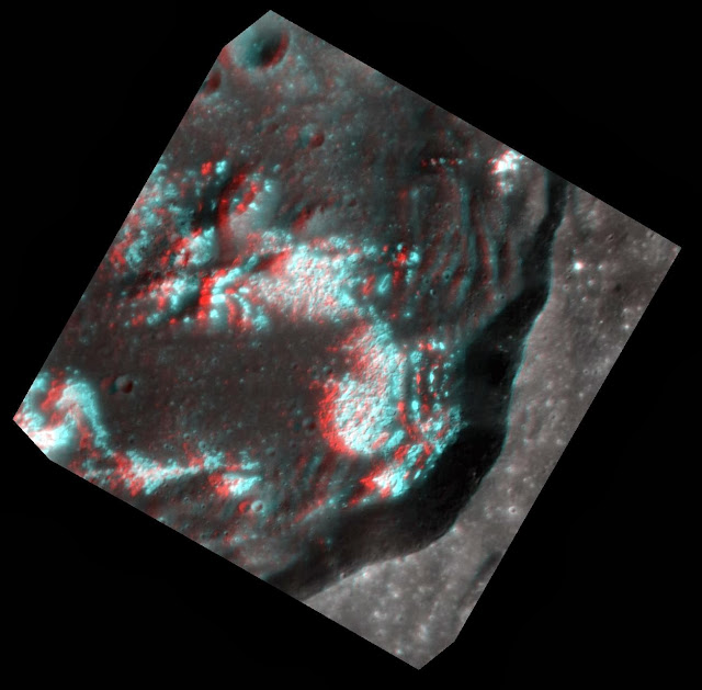
Today's image is another chance to whip out your red-cyan 3D glasses! This multidimensional view, where north is to the left, helps bring to life the extensive hollow network on the crater floor. Look how these bright, irregular depressions create such a dramatic etched appearance!
This image was acquired as a targeted set of stereo images. Targeted stereo observations are acquired at resolutions much higher than that of the 200-meter/pixel stereo base map. These targets acquired with the NAC enable the detailed topography of Mercury's surface to be determined for a local area of interest.
Date acquired: April 24, 2013
Image Mission Elapsed Time (MET): 9145650, 9145778
Image ID: 3944041, 3944042
Instrument: Narrow Angle Camera (NAC) of the Mercury Dual Imaging System (MDIS)
Center Latitude: 40.26°
Center Longitude: 221.9° E
Resolution: 24 meters/pixel, 28 meters/pixel
Scale: Crater diameter is about 35 km (21.7 miles)
Incidence Angle: 44.6°
Emission Angle: 2.1° 19.9°
Phase Angle: 43.3° 29.4°
Photo credit: NASA/Johns Hopkins University Applied Physics Laboratory/Carnegie Institution of Washington

Today's color image features Hovnatanian crater, named for Armenian painter Hakop Hovnatanian. The crater's elliptical shape and the bright rays' butterfly pattern indicate that a very oblique impact produced Hovnatanian. The brightness of the rays indicate that they are relatively young features on Mercury's surface.
This image was acquired as a targeted high-resolution 11-color image set. Acquiring 11-color targets is a new campaign that began in March 2013 and that utilizes all of the WAC's 11 narrow-band color filters. Because of the large data volume involved, only features of special scientific interest are targeted for imaging in all 11 colors.
Date acquired: May 01, 2013
Image Mission Elapsed Time (MET): 9751363, 9751355, 9751351
Image ID: 3986986, 3986984, 3986983
Instrument: Wide Angle Camera (WAC) of the Mercury Dual Imaging System (MDIS)
WAC filters: 9, 7, 6 (996, 748, 433 nanometers) in red, green, and blue
Center Latitude: -7.39°
Center Longitude: 172.9° E
Resolution: 394 meters/pixel
Scale: Hovnatanian crater is about 34 km (21 miles) long.
Incidence Angle: 15.7°
Emission Angle: 40.0°
Phase Angle: 28.0°
Photo credit: NASA/Johns Hopkins University Applied Physics Laboratory/Carnegie Institution of Washington


