skip to main |
skip to sidebar

Red-cyan glasses will help you see the impressive heights of Paramour Rupes in this 3D view. Paramour is a large cliff (well over 600 meters high at places!) that formed when one block of crust was thrust forward over another, resulting in a feature known as a lobate scarp. Paramour Rupes is located to the southwest of the Caloris basin, and the small knobs that litter the scene are thought to be blocks of ejecta from the Caloris impact event. For ease of stereo viewing, this anaglyph has been rotated so that north is toward the left.
This image pair was acquired as a targeted set of stereo images. Targeted stereo observations are acquired at resolutions much higher than that of the 200-meter/pixel stereo base map. These targets acquired with the NAC enable the detailed topography of Mercury's surface to be determined for a local area of interest.
Date acquired: June 18, 2014
Image Mission Elapsed Time (MET): 45386688, 45387906
Image ID: 6520353, 6520362
Instrument: Narrow Angle Camera (NAC) of the Mercury Dual Imaging System (MDIS)
Center Latitude: -4.99°
Center Longitude: 146.3°E
Resolution: 110 meters/pixel
Scale: This scene is approximately 110 km (68 miles) across
Incidence Angle: 63.8°
Emission Angle: 37.2°
Phase Angle: 97.7°
Image credit: NASA/Johns Hopkins University Applied Physics Laboratory/Carnegie Institution of Washington

With your red-cyan glasses on, check out this stereo view inside the complex crater Catullus. Here you can see the central peaks rising above the relatively smooth floor of the crater. To the right of the peaks, a large, irregularly shaped pit sinks down below the level of the crater floor. This pit may have formed due to past volcanic activity within the impact crater.
These images were acquired as a targeted set of stereo images. Targeted stereo observations are acquired at resolutions much higher than that of the 200-meter/pixel stereo base map. These targets acquired with the NAC enable the detailed topography of Mercury's surface to be determined for a local area of interest.
Date acquired: July 25, 2014
Image Mission Elapsed Time (MET): 48654092, 48654444
Image ID: 6751776, 6751777
Instrument: Narrow Angle Camera (NAC) of the Mercury Dual Imaging System (MDIS)
Center Latitude: 21.91°
Center Longitude: 292.8° E
Resolution: 48 meters/pixel
Scale: Pit is approximately 18 km (11 miles) across
Incidence Angle: 68.5°
Emission Angle: 11.9°
Phase Angle: 73.0°
Image credit: NASA/Johns Hopkins University Applied Physics Laboratory/Carnegie Institution of Washington

Today's image is located on the western edge of the Rembrandt basin. A scarp cuts right through a pair of older impact craters, leaving them deformed. This image is an anaglyph, which creates a 3D effect when viewed through a pair of red-cyan glass. If you've found a pair of glasses, check out these other 3D views created with MESSENGER images.
This image was acquired as a targeted set of stereo images. Targeted stereo observations are acquired at resolutions much higher than that of the 200-meter/pixel stereo base map. These targets acquired with the NAC enable the detailed topography of Mercury's surface to be determined for a local area of interest.
Date acquired: August 13, 2013
Image Mission Elapsed Time (MET): 18733660, 18734492
Image ID: 4625953, 4625956
Instrument: Narrow Angle Camera (NAC) of the Mercury Dual Imaging System (MDIS)
Center Latitude: -37.6°
Center Longitude: 79.15° E
Resolution: 100 meters/pixel
Scale: This image is roughly 90 kilometers across (56 miles)
Incidence Angle: 81.0°, 81.0°
Emission Angle: 0.3°, 19.9°
Phase Angle: 81.2°, 81.9°
Orientation: North is to the right to enhance the 3D effect.
Image credit: NASA/Johns Hopkins University Applied Physics Laboratory/Carnegie Institution of Washington

Today's image is an anaglyph, which means if you have a pair of red-cyan glasses, you can see the image in 3D. While this peak, which is slightly over a kilometer tall, is located within a circular depression, it is much larger relative to the size of the depression than other central peaks that formed during impact cratering events on Mercury. Additionally, the feature has a distinctive red color signature, associated with sites of explosive volcanic eruptions on Mercury. Peaks such as this one are rare on Mercury, but there is a similar one nearby that also shares the same red color characteristics.
This image was acquired as a targeted set of stereo images. Targeted stereo observations are acquired at resolutions much higher than that of the 200-meter/pixel stereo base map. These targets acquired with the NAC enable the detailed topography of Mercury's surface to be determined for a local area of interest.
Date acquired: November 14, 2013
Image Mission Elapsed Time (MET): 26772351, 26772627
Image ID: 5197359, 5197360
Instrument: Narrow Angle Camera (NAC) of the Mercury Dual Imaging System (MDIS)
Center Latitude: -8.50°
Center Longitude: 224.4° E
Resolution: 50 meters/pixel
Scale: This image is roughly 45 km (28 miles) across
Incidence Angle: 44.7°, 44.6°
Emission Angle: 14.2°, 24.6°
Phase Angle: 59.0°, 62.2°
Orientation: North is to the right, to enhance the 3D effect.
Image credit: NASA/Johns Hopkins University Applied Physics Laboratory/Carnegie Institution of Washington

Like yesterday's image, and the one from last week, today's image features the same potential volcanic vent. However, today's image is actually a combination of two additional images that were taken by the spacecraft 255 seconds apart. During that time of just over 4 minutes, the spacecraft had moved enough to provide slightly different viewing angles of the same surface, enabling this 3D representation to be made. Find a pair of red-cyan glasses to view the 3D image, and the image has been rotated such that north is to the left to enhance the 3D effect.
This image was acquired as a targeted set of stereo images. Targeted stereo observations are acquired at resolutions much higher than that of the 200-meter/pixel stereo base map. These targets acquired with the NAC enable the detailed topography of Mercury's surface to be determined for a local area of interest.
Date acquired: July 02, 2013
Image Mission Elapsed Time (MET): 15108910, 15109165
Image ID: 4368031, 4368047
Instrument: Narrow Angle Camera (NAC) of the Mercury Dual Imaging System (MDIS)
Center Latitude: 24.28°
Center Longitude: 148.3° E
Resolution: 44 meters/pixel
Scale: This image is 40 km (25 miles) across
Incidence Angle: 72.2°
Emission Angle: 26.1°, 32.9°
Phase Angle: 98.2°, 96.3°
Photo credit: NASA/Johns Hopkins University Applied Physics Laboratory/Carnegie Institution of Washington
Joplin crater stands out brilliantly in 3D. With red-cyan glasses, you get an amazing view of Joplin's central peak, which rises around 1 km (0.6 mi.) above the crater floor. This picture has been rotated so that north is toward the bottom to enhance the 3D effect.
Date acquired: January 16, 2012
Image Mission Elapsed Time (MET): 235169452, 235423824
Image ID: 1271337, 1283624
Instrument: Narrow Angle Camera (NAC) of the Mercury Dual Imaging System (MDIS)
Center Latitude: -38.87° -39.34°
Center Longitude: 26.48° E 26.44° E
Resolution: 176 meters/pixel 187 meters/pixel
Scale: Joplin crater is 135 km (84 mi) in diameter
Incidence Angle: 75.2° 67.9°
Emission Angle: 21.6° 33.4°
Phase Angle: 80.3° 92.6°
Photo credit: NASA/Johns Hopkins University Applied Physics Laboratory/Carnegie Institution of Washington
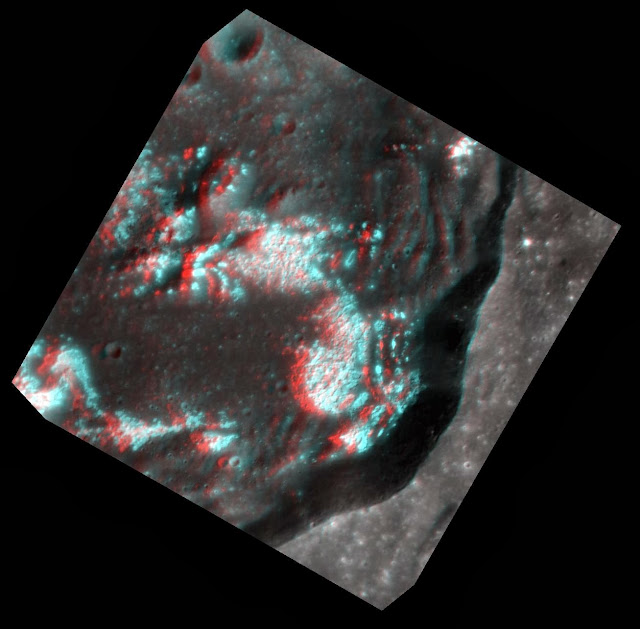
Today's image is another chance to whip out your red-cyan 3D glasses! This multidimensional view, where north is to the left, helps bring to life the extensive hollow network on the crater floor. Look how these bright, irregular depressions create such a dramatic etched appearance!
This image was acquired as a targeted set of stereo images. Targeted stereo observations are acquired at resolutions much higher than that of the 200-meter/pixel stereo base map. These targets acquired with the NAC enable the detailed topography of Mercury's surface to be determined for a local area of interest.
Date acquired: April 24, 2013
Image Mission Elapsed Time (MET): 9145650, 9145778
Image ID: 3944041, 3944042
Instrument: Narrow Angle Camera (NAC) of the Mercury Dual Imaging System (MDIS)
Center Latitude: 40.26°
Center Longitude: 221.9° E
Resolution: 24 meters/pixel, 28 meters/pixel
Scale: Crater diameter is about 35 km (21.7 miles)
Incidence Angle: 44.6°
Emission Angle: 2.1° 19.9°
Phase Angle: 43.3° 29.4°
Photo credit: NASA/Johns Hopkins University Applied Physics Laboratory/Carnegie Institution of Washington

As promised in yesterday's featured image, here is another 3D anaglyph that was created from recently acquired images. View it with a pair of red-cyan 3D glasses to get the full effect and to see deep into this crater. The topography appears exaggerated in the stereo view of this roughly one-kilometer deep crater, accentuating the terraces on the crater's walls and the central peak, topped with hollows, rising from the crater's floor. This image has been rotated 90° to the right (such that north is to the right) for better viewing with the red-cyan glasses.
Date acquired: March 22, 2013
Image Mission Elapsed Time (MET) (since January 8, 2013): 6291928, 6292156
Image ID: 3741269, 3741270
Instrument: Narrow Angle Camera (NAC) of the Mercury Dual Imaging System (MDIS)
Center Latitude: 25.11°
Center Longitude: 266.4° E
Resolution: 36 meters/pixel
Scale: The diameter of this crater is 31 kilometers (19 miles)
Incidence Angle: 44.7°, 44.8°
Emission Angle: 40.5°, 35.5°
Phase Angle: 72.9°, 78.1°
Photo credit: NASA/Johns Hopkins University Applied Physics Laboratory/Carnegie Institution of Washington


 Posts


