skip to main |
skip to sidebar

The surface of Mercury is dominated by impact craters, so it is not surprising that every so often one crater forms atop another. In this image, a small crater formed close to the southern margin of Mercury's northern volcanic plains, before being superposed by a slightly larger and deeper crater. This second impact removed over a third of the smaller, pre-existing crater. Yet both craters show evidence of post-formation modification, notably where their walls meet their floors. For example, a hill lies at the base of the right-hand-side wall of the larger crater. This is likely a landslide deposit that formed when material slumped off the wall.
This image was acquired as a high-resolution targeted observation. Targeted observations are images of a small area on Mercury's surface at resolutions much higher than the 200-meter/pixel morphology base map. It is not possible to cover all of Mercury's surface at this high resolution, but typically several areas of high scientific interest are imaged in this mode each week.
Date acquired: July 10, 2014
Image Mission Elapsed Time (MET): 47351839
Image ID: 6659618
Instrument: Narrow Angle Camera (NAC) of the Mercury Dual Imaging System (MDIS)
Center Latitude: 52.3°
Center Longitude: 31.6° E
Resolution: 22 meters/pixel
Scale: The crater at center-right is approximately 10 km (6.2 miles) across
Incidence Angle: 54.1°
Emission Angle: 28.3°
Phase Angle: 45.2°
Orientation: North is to the right in this image.
Image credit: NASA/Johns Hopkins University Applied Physics Laboratory/Carnegie Institution of Washington

Today's color image features a small crater in Mercury's northern hemisphere. This relatively young crater is highlighted by its striking white rays, which contrast the darker, surrounding terrain of low reflectance material. The bright rays result from fine-grained and relatively unweathered material that was ejected and deposited by the impact.
This image was acquired as a targeted high-resolution 11-color image set. Acquiring 11-color targets is a new campaign that began in March 2013 and that utilizes all of the WAC's 11 narrow-band color filters. Because of the large data volume involved, only features of special scientific interest are targeted for imaging in all 11 colors.
Date acquired: July 08, 2014
Image Mission Elapsed Time (MET): 47178430, 47178426, 47178424
Image ID: 6647334, 6647332, 6647331
Instrument: Wide Angle Camera (WAC) of the Mercury Dual Imaging System (MDIS)
WAC filters: 9, 7, 6 (996, 748, 433 nanometers) in red, green, and blue
Center Latitude: 43.97°
Center Longitude: 34.76° E
Resolution: 348 meters/pixel
Scale: The crater on the right of this image is approximately 16 km (10 miles) across
Incidence Angle: 45.9°
Emission Angle: 1.6°
Phase Angle: 44.9°
Image credit: NASA/Johns Hopkins University Applied Physics Laboratory/Carnegie Institution of Washington

Wrinkle ridges are tectonic landforms observed across all of Mercury's smooth plains deposits, and are often superposed by impact craters. Craters themselves are frequently surrounded by lobate-like ejecta deposits, which at first glance might look like tectonic structures. In this image, a lobate-like feature runs parallel to the northern margin of an unnamed crater 20 km (12 miles) in diameter. Whether this landform is tectonic or impact-related is not yet clear, but with continued high-resolution imaging of other, similarly sized craters, we might be able to tell.
This image was acquired as a high-resolution targeted observation. Targeted observations are images of a small area on Mercury's surface at resolutions much higher than the 200-meter/pixel morphology base map. It is not possible to cover all of Mercury's surface at this high resolution, but typically several areas of high scientific interest are imaged in this mode each week.
Date acquired: March 6, 2014
Image Mission Elapsed Time (MET): 36395675
Image ID: 5881419
Instrument: Narrow Angle Camera (NAC) of the Mercury Dual Imaging System (MDIS)
Center Latitude: 66.3°
Center Longitude: 281.8° E
Resolution: 12 meters/pixel
Scale: The field of view in this image is 14 km (9 mi.) across
Incidence Angle: 70.5°
Emission Angle: 0.3°
Phase Angle: 70.2°
North is to the right in this scene.
Image credit: NASA/Johns Hopkins University Applied Physics Laboratory/Carnegie Institution of Washington
This high-resolution image reveals a few melt ponds, which appear smoother than the surrounding terrain. These melt ponds were deposited as ejecta from this crater, which lies off to the north (top) of this image.
This image was acquired as a high-resolution targeted observation. Targeted observations are images of a small area on Mercury's surface at resolutions much higher than the 200-meter/pixel morphology base map. It is not possible to cover all of Mercury's surface at this high resolution, but typically several areas of high scientific interest are imaged in this mode each week.
Date acquired: March 10, 2014
Image Mission Elapsed Time (MET): 36770132
Image ID: 5908036
Instrument: Narrow Angle Camera (NAC) of the Mercury Dual Imaging System (MDIS)
Center Latitude: 63.77°
Center Longitude: 254.7° E
Resolution: 12 meters/pixel
Scale: The elliptical melt pond is approximately 1 km (0.6 mi.) in length.
Incidence Angle: 72.5°
Emission Angle: 6.3°
Phase Angle: 78.9°
Image credit: NASA/Johns Hopkins University Applied Physics Laboratory/Carnegie Institution of Washington
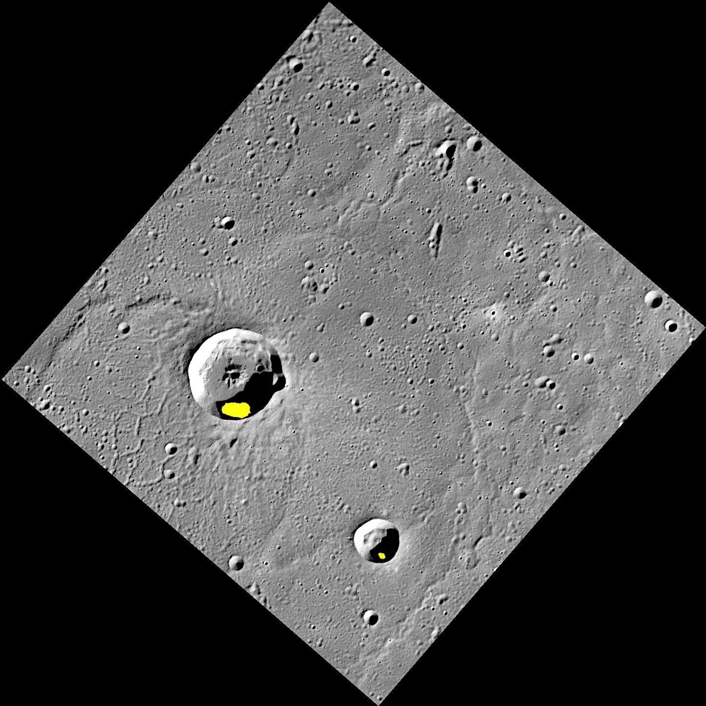
Finding evidence for water ice on the planet closest to the Sun was an exciting discovery, but there is still more to learn about Mercury's icy deposits. Regions of permanent shadow seem to be a requirement for water ice to reside on the Solar System's innermost planet, so the large majority of Mercury's water ice deposits are located within impact craters at high latitudes. The two craters shown here, Egonu and Monk, both appear to have areas of permanent shadow and radar-bright deposits (shown in yellow) that are associated with water ice. However these craters are located a fair distance from Mercury's pole, all the way down at 66° latitude! How long can ice stay in these craters? That is just one of the interesting questions about Mercury's water ice deposits still being investigated.
This image was acquired as part of MDIS's high-resolution surface morphology base map. The surface morphology base map covers more than 99% of Mercury's surface with an average resolution of 200 meters/pixel. Images acquired for the surface morphology base map typically are obtained at off-vertical Sun angles (i.e., high incidence angles) and have visible shadows so as to reveal clearly the topographic form of geologic features.
Date acquired: July 20, 2011
Image Mission Elapsed Time (MET): 219648898
Image ID: 528063
Instrument: Wide Angle Camera (WAC) of the Mercury Dual Imaging System (MDIS)
WAC filter: 7 (748 nanometers)
Center Latitude: 67.29°
Center Longitude: 63.51° E
Resolution: 133 meters/pixel
Scale: Egonu has a diameter of 25 km (16 miles); Monk has a diameter of 13 km (8 miles)
Incidence Angle: 74.5°
Emission Angle: 0.2°
Phase Angle: 74.5°
Arecibo Radar Image: Shown in yellow, from Harmon et al., Icarus, 211, 37-50 (2011)
Image credit: NASA/Johns Hopkins University Applied Physics Laboratory/Carnegie Institution of Washington

In the center of this image is a high-reflectance area that seems to be confined to a region of lower elevation that is bounded by linear scarp (cliff) segments. Such diffuse bright areas are sometimes related to the deposition of small secondary craters and ray segments by a relatively recent impact crater, but looking at regional images (for example, using QuickMap), there are no rayed craters in the immediate vicinity (though Han Kan might be a candidate). Therefore, a compositional difference may account for the difference in the albedo (brightness) of the material in the low-lying area. Are the scarps tectonic in nature (the result of vertical movement along faults), or were they formed by secondary crater chains? Also of interest in the scene are hollows on the central peak of the crater at the upper left, and the smooth impact melt on the floor of the terrace-walled crater just below center. Scientists will be at work for many years to solve the puzzle of Mercury's complicated geological history!
This image was acquired as part of the NAC ride-along imaging campaign. When data volume is available and MDIS is not acquiring images for its other campaigns, high-resolution NAC images are obtained of the surface. These images are designed not to interfere with other instrument observations but take full advantage of periods during the mission when extra data volume is available.
Date acquired: May 19, 2012
Image Mission Elapsed Time (MET): 245904903
Image ID: 1853014
Instrument: Narrow Angle Camera (NAC) of the Mercury Dual Imaging System (MDIS)
Center Latitude: -47.3°
Center Longitude: 177.3° E
Resolution: 179 meters/pixel
Scale: The scene is about 184 km (114 mi.) across
Incidence Angle: 47.7°
Emission Angle: 24.2°
Phase Angle: 71.9°
Photo credit: NASA/Johns Hopkins University Applied Physics Laboratory/Carnegie Institution of Washington

This image brings us back to the vicinity of Matisse, the subject of several recent Gallery images. The unnamed impact crater with the bright pyroclastic deposit on its southern floor also has two arcuate scallops on its northern wall. These were the sites of massive landslides that took place when the oversteepened crater wall collapsed. The ultimate cause of the collapse is the topography of the area where the crater formed: the northern part of the crater formed on the wall of Matisse.
This image was acquired as part of MDIS's high-resolution albedo base map. The best images for discerning variations in albedo, or brightness, on the surface are acquired when the Sun is overhead, so these images typically are taken at low incidence angles. The albedo base map covers Mercury's surface at an average resolution of 200 meters/pixel.
Date acquired: April 05, 2012
Image Mission Elapsed Time (MET): 242124773
Image ID: 1609270
Instrument: Narrow Angle Camera (NAC) of the Mercury Dual Imaging System (MDIS)
Center Latitude: -22.85°
Center Longitude: 267.3° E
Resolution: 196 meters/pixel
Scale: The crater with the bright floor is about 70 km (44 mi.) in diameter
Incidence Angle: 40.8°
Emission Angle: 30.0°
Phase Angle: 70.8°
Photo credit: NASA/Johns Hopkins University Applied Physics Laboratory/Carnegie Institution of Washington

Today's image features several craters near the eastern edge of the Caloris basin. The larger craters have excavated low reflectance material, and both have hollows forming within their floors. Reddish deposits that exhibit a spectral signature similar to pyroclastics occur in the northeastern quadrant of this scene, suggesting that this region may have once been the site of explosive volcanism.
This image was acquired as a targeted high-resolution 11-color image set. Acquiring 11-color targets is a new campaign that began in March 2013 and that utilizes all of the WAC's 11 narrow-band color filters. Because of the large data volume involved, only features of special scientific interest are targeted for imaging in all 11 colors.
Date acquired: October 24, 2013
Image Mission Elapsed Time (MET): 24470528, 24960452, 24470516
Image ID: 5033545, 5068359, 5033542
Instrument: Wide Angle Camera (WAC) of the Mercury Dual Imaging System (MDIS)
WAC filters: 9, 7, 6 (996, 748, 433 nanometers) in red, green, and blue
Center Latitude: 23.72°
Center Longitude: 179.1° E
Resolution: 260 meters/pixel
Scale: The larger crater near the top of the image is approximately 54 km (33.5 mi.) in diameter.
Incidence Angle: 24.8°
Emission Angle: 8.4°
Phase Angle: 33.2°
Photo credit: NASA/Johns Hopkins University Applied Physics Laboratory/Carnegie Institution of Washington

Today's feature is the 748-nm filter image from from the October 21, 2013 color presentation. The graphs underneath the image illustrate a basic principle of image processing: the contrast stretch. A computer is typically capable of displaying a black and white ("greyscale") image as a series of pixels with 256 levels of brightness, between 0 (black) and 255 (white). Therefore, in order to be displayed, the numerical values of the image must be "stretched" to cover the range 0 to 255. In the case of a calibrated MDIS image, the image values are in physical units of reflectance -- that is, the percentage of incident light that the surface reflects. The graphs underneath the image are histograms. The x-axis is the range of pixel values that occur in the image, and the y-axis is the frequency of the values. The histogram on the lower left shows that the range of reflectance values in the image is from about 0.02 to 0.07 (or about 2% to 7% reflectance). The plot peaks at about 0.04, indicating that the most frequent pixel value is about 0.04. The plot on the lower right shows how the input pixel values have been scaled from 0 to 255 to produce the image above. Note that to display a color image (i.e., in red-green-blue), each of the three input color planes is stretched separately.
This image was acquired as a high-resolution targeted color observation. Targeted color observations are images of a small area on Mercury's surface at resolutions higher than the 1-kilometer/pixel 8-color base map. During MESSENGER's one-year primary mission, hundreds of targeted color observations were obtained. During MESSENGER's extended mission, high-resolution targeted color observations are more rare, as the 3-color base map covered Mercury's northern hemisphere with the highest-resolution color images that are possible.
Date acquired: October 21, 2012
Image Mission Elapsed Time (MET): 259266840
Image ID: 2803280
Instrument: Wide Angle Camera (WAC) of the Mercury Dual Imaging System (MDIS)
WAC filter: 7 (748 nanometers)
Center Latitude: -23.00°
Center Longitude: 268.4° E
Resolution: 674 meters/pixel
Scale: The scene is about 890 km (553 mi.) across
Incidence Angle: 45.6°
Emission Angle: 33.5°
Phase Angle: 78.7°
North is up in this image.
Image credit: NASA/Johns Hopkins University Applied Physics Laboratory/Carnegie Institution of Washington

This color view of the vicinity of Matisse crater, seen in an early Gallery image from MESSENGER's first flyby of Mercury in 2008. Two unnamed craters formed tangentially to the rim of Matisse (one just inside the rim, and one just outside). These craters have bright orange deposits on their floors. High reflectance and a greater-than-average ("red") spectral slope create the orange appearance in this color presentation. Such color characteristics are found at many other locations on Mercury where pyroclastic volcanic eruptions took place.
This image was acquired as a high-resolution targeted color observation. Targeted color observations are images of a small area on Mercury's surface at resolutions higher than the 1-kilometer/pixel 8-color base map. During MESSENGER's one-year primary mission, hundreds of targeted color observations were obtained. During MESSENGER's extended mission, high-resolution targeted color observations are more rare, as the 3-color base map covered Mercury's northern hemisphere with the highest-resolution color images that are possible.
Date acquired: October 21, 2012
Image Mission Elapsed Time (MET): 259266820, 259266840, 259266824
Image ID: 2803275, 2803280, 2803276
Instrument: Wide Angle Camera (WAC) of the Mercury Dual Imaging System (MDIS)
WAC filters: 9, 7, 6 (996, 748, 433 nanometers) in red, green, and blue
Center Latitude: -23.00°
Center Longitude: 268.4° E
Resolution: 674 meters/pixel
Scale: The scene is about 890 km (553 mi.) across; Matisse crater is about 186 km (116 mi.) in diameter
Incidence Angle: 45.6°
Emission Angle: 33.5°
Phase Angle: 78.7°
North is up in this image.
Photo credit: NASA/Johns Hopkins University Applied Physics Laboratory/Carnegie Institution of Washington

The large, older crater featured in today's image is Steichen. At almost 200 km (124 mi.) across, Streichen is a complex impact basin, with a central peak ring that is partially buried by smooth crater floor deposits. Though much of the northwestern central peak ring is buried, one tiny, bright blue speck surrounded by a dark blue halo pokes up through the smooth floor deposits, hinting that hollows might be forming in a little patch of excavated low-reflectance material.
This image was acquired as part of MDIS's 8-color base map. The 8-color base map is composed of WAC images taken through eight different narrow-band color filters and covers more than 99% of Mercury's surface with an average resolution of 1 kilometer/pixel. The highest-quality color images are obtained for Mercury's surface when both the spacecraft and the Sun are overhead, so these images typically are taken with viewing conditions of low incidence and emission angles.
Date acquired: August 13, 2011
Image Mission Elapsed Time (MET): 221758501, 221758509, 221758503
Image ID: 628307, 628312, 628308
Instrument: Wide Angle Camera (WAC) of the Mercury Dual Imaging System (MDIS)
WAC filters: 9, 7, 6 (996, 748, 433 nanometers) in red, green, and blue
Center Latitude: -12.53°
Center Longitude: 78.18° E
Resolution: 623 meters/pixel
Scale: Steichen crater is 196 km (122 mi.) in diameter.
Incidence Angle: 48.3°
Emission Angle: 0.2°
Phase Angle: 48.2°
Photo credit: NASA/Johns Hopkins University Applied Physics Laboratory/Carnegie Institution of Washington
This beautiful view of the volcanic vents located to the north of the Rachmaninoff basin gives a new perspective on the area. At center, a vent is located within the bright pyroclastic deposit that is thought to have erupted from the vent. An older vent is also seen toward the bottom right as an irregularly shaped depression, though it has no clear surrounding deposit. The oblique angle of the image allows a view of the eastern walls of these features.
Date acquired: August 23, 2013
Image Mission Elapsed Time (MET): 19543205
Image ID: 4683301
Instrument: Wide Angle Camera (WAC) of the Mercury Dual Imaging System (MDIS)
WAC filter: 7 (748 nanometers)
Center Latitude: 35.77°
Center Longitude: 63.90° E
Scale: The central vent is approximately 36 km (22 mi.) across.
Photo credit: NASA/Johns Hopkins University Applied Physics Laboratory/Carnegie Institution of Washington
This surface, located around the central peak ring of the crater Praxiteles, exhibits the effects that both hollows and pyroclastic deposits can have on pre-existing features. The peak ring (located to the left of this image) can be thought of as being eroded or depressed from the combination of such features. Pyroclastic deposits disturb surface material through volcanic-like events, and hollows are believed to be caused by the sublimation of volatiles, which release sub-surface material and depress the surface even further.
Date acquired: September 04, 2011
Image Mission Elapsed Time (MET): 223615476
Image ID: 716372
Instrument: Narrow Angle Camera (NAC) of the Mercury Dual Imaging System (MDIS)
Center Latitude: 27.24°
Center Longitude: 301.0° E
Resolution: 19 meters/pixel
Scale: This image is about 20 km (12 mi.) across.
Incidence Angle: 62.4°
Emission Angle: 0.5°
Phase Angle: 61.8°
Photo credit: NASA/Johns Hopkins University Applied Physics Laboratory/Carnegie Institution of Washington
This volcano-like feature is found in Kipling crater and shares similarities to other pyroclastic deposits on Mercury. Where on Earth volcanoes frequently form mountains, on Mercury most of the "volcanoes" that have been identified are characterized by pits or depressions. Described as rimless depressions with irregular shapes, most pyroclastic deposits on Mercury are on the order of a few tens of kilometers in size.
Date acquired: August 16, 2011
Image Mission Elapsed Time (MET): 221974660
Image ID: 638531
Instrument: Narrow Angle Camera (NAC) of the Mercury Dual Imaging System (MDIS)
Center Latitude: -19.15°
Center Longitude: 71.37° E
Resolution: 51 meters/pixel
Scale: From top to bottom, this feature measures approx. 35 km (22 mi.)
Incidence Angle: 49.7°
Emission Angle: 18.1°
Phase Angle: 31.6°
Photo credit: NASA/Johns Hopkins University Applied Physics Laboratory/Carnegie Institution of Washington
This false color image shows a bright fresh crater exhibiting possible evidence of a pyroclastic deposit on its eastern side (shown by the bright yellow); as well as a series of secondaries which have excavated sub-surface material resulting in the blues seen in the north-east corner of the image.
Date acquired: November 06, 2011
Image Mission Elapsed Time (MET): 229105596, 229105592, 229105588
Image ID: 980566, 980565, 980564
Instrument: Wide Angle Camera (WAC) of the Mercury Dual Imaging System (MDIS)
WAC filters: 9, 7, 6 (996, 748, 433 nanometers) in red, green, and blue
Center Latitude: 25.42°
Center Longitude: 266.8° E
Resolution: 121 meters/pixel
Scale: The bright unnamed crater is about 33 km in diameter (21mi.)
Incidence Angle: 52.3°
Emission Angle: 16.8°
Phase Angle: 69.1°
Photo credit: NASA/Johns Hopkins University Applied Physics Laboratory/Carnegie Institution of Washington

The plains that surround the Caloris basin are geologically complex. Today's featured images highlights some of the kilometer-scale knobs that surround much of the basin, which are thought to be blocks of material ejected by the Caloris basin-forming event. This area, a region within Tir Planitia, has also been subjected to compressional stresses, which resulted in the formation of scarps that cut across the scene. Unraveling the complex sequence of events in this region, which includes deposition of ejecta, possible volcanic resurfacing, and tectonic deformation, will be aided by the high-resolution targeted images to be collected in MESSENGER's second extended mission.
Date acquired: April 05, 2013
Image Mission Elapsed Time (MET): 7472448
Image ID: 3825184
Instrument: Narrow Angle Camera (NAC) of the Mercury Dual Imaging System (MDIS)
Center Latitude: 4.31°
Center Longitude: 185.6° E
Resolution: 61 meters/pixel
Scale: This scene is approximately 80 km (50 mi.) across
Incidence Angle: 73.6°
Emission Angle: 40.8°
Phase Angle: 114.1°
Photo credit: NASA/Johns Hopkins University Applied Physics Laboratory/Carnegie Institution of Washington

At the center of today's image is a "red spot," an informal designation used by the MESSENGER team to refer to an area with overall high reflectance and higher than average reflectance at the longer-wavelength (red) end of the spectrum. Red spots are thought to be sites of explosive (pyroclastic) volcanic eruptions. Such deposits were analyzed in a 2011 paper. A close-up of the crater at the center of the red spot was presented in a previous Gallery image. The crater neat the left edge of the image with bright floor deposits (hollows) is Theophanes.
Date acquired: December 14, 2011
Image Mission Elapsed Time (MET): 232328601, 232328621, 232328605
Image ID: 1134128, 1134133, 1134129
Instrument: Wide Angle Camera (WAC) of the Mercury Dual Imaging System (MDIS)
WAC filters: 9, 7, 6 (996, 748, 433 nanometers) in red, green, and blue
Center Latitude: -3.73°
Center Longitude: 223.8° E
Resolution: 725 meters/pixel
Scale: The scene is about 750 km (465 mi.) wide.
Incidence Angle: 44.7°
Emission Angle: 0.3°
Phase Angle: 44.8°
Photo credit: NASA/Johns Hopkins University Applied Physics Laboratory/Carnegie Institution of Washington
The recently named Donalaitis crater near the center of this image exhibits bright reddish deposits on its floor, which contrast starkly with the more relatively blue hues of the surrounding terrain. Donelaitis crater was named for Kristijonas Donelaitis (1714-1780), a Lithuanian poet. His classic poem, 'The Seasons (Metai)', describes the lives of Lithuanian peasants, who at the time of its writing were being pushed into serfdom as most of their country was annexed by the Russian Empire.
Date acquired: August 21, 2011
Image Mission Elapsed Time (MET): 222408661, 222408681, 222408665
Image ID: 658976, 658981, 658977
Instrument: Wide Angle Camera (WAC) of the Mercury Dual Imaging System (MDIS)
WAC filters: 9, 7, 6 (996, 748, 433 nanometers) in red, green, and blue
Center Latitude: -51.81°
Center Longitude: 39.11° E
Resolution: 874 meters/pixel
Scale: Donelaitis crater is 84.5 km (52.5 mi.) across.
Incidence Angle: 56.2°
Emission Angle: 0.5°
Phase Angle: 55.7°
Photo credit: NASA/Johns Hopkins University Applied Physics Laboratory/Carnegie Institution of Washington

This oblique view highlights, from top to bottom, Balzac, Phidias, Tyagaraja, Stevenson, and Zeami craters. While named craters are still sparse across much of Mercury, this region was observed by Mariner 10, allowing for plenty of time to propose names. In Mariner 10 images of Mercury, craters like Tyagaraja and Zeami were described as hosting bright floor deposits, but the relatively low resolution at which they were imaged did not allow for a more detailed analysis. We now know that craters such as these host hollows (see the links above for higher resolution images of each crater in this scene).
Date acquired: November 26, 2012
Image Mission Elapsed Time (MET): 262401199, 262401219, 262401203
Image ID: 3026482, 3026487, 3026483
Instrument: Wide Angle Camera (WAC) of the Mercury Dual Imaging System (MDIS)
WAC filters: 9, 7, 6 (996, 748, 433 nanometers) in red, green, and blue
Center Latitude: 4.64°
Center Longitude: 210.5° E
Resolution: 698 meters/pixel
Scale: Tyagaraja crater (center) is approximately 97 km (60 mi.) in north-south diameter
Incidence Angle: 30.2°
Emission Angle: 57.5°
Phase Angle: 83.8°
North is up in this image.
Photo credit: NASA/Johns Hopkins University Applied Physics Laboratory/Carnegie Institution of Washington

Here is a color view of the southern part of the Caloris basin. Extending along the southern rim are a number of pyroclastic deposits that have a distinctive reddish color. The inset locator map shows the entire Caloris basin; the red dots correspond to mapped pyroclastic deposits, which formed during explosive volcanic eruptions. On the Earth, volcanoes are often associated with boundaries where tectonic plates interact. The Pacific "Ring of Fire" is a famous example of volcanism found at plate boundaries. Mercury, by contrast, is a one-plate planet. Instead, Mercurian volcanism is largely controlled by fracturing or tectonic features related to impact basins and craters. Caloris's southern rim is a partial "ring of fire."
This image is part of MDIS's high-resolution 3-color mosaic. The 3-color campaign is a major mapping activity in MESSENGER's extended mission. It complements the 8-color base map (at an average resolution of 1 km/pixel) acquired during MESSENGER's primary mission by imaging Mercury's surface in a subset of the color filters at the highest resolution possible. The three narrow-band color filters are centered at wavelengths of 430 nm, 750 nm, and 1000 nm, and image resolutions generally range from 100 to 400 meters/pixel in the northern hemisphere. The inset is part of Fig. 4 of L. Kerber et al., (2011), Planet. Space Sci. 59, 1895-1909.
Instrument: Wide Angle Camera (WAC) of the Mercury Dual Imaging System (MDIS)
WAC filter: 9, 7, 6 (1000, 750, 430 nanometers) in red, green, and blue.
Center Latitude: 22.8°
Center Longitude: 156.9° E
Resolution: 1000 meters/pixel
Scale: Atget, the dark-floored crater near the right edge, is 100 km (62 mi.) in diameter.
Photo credit: NASA/Johns Hopkins University Applied Physics Laboratory/Carnegie Institution of Washington0


