Showing posts with label Radar Astronomy. Show all posts

Saturday, April 26, 2014

Possible Ice Deposits in Egonu and Monk Craters


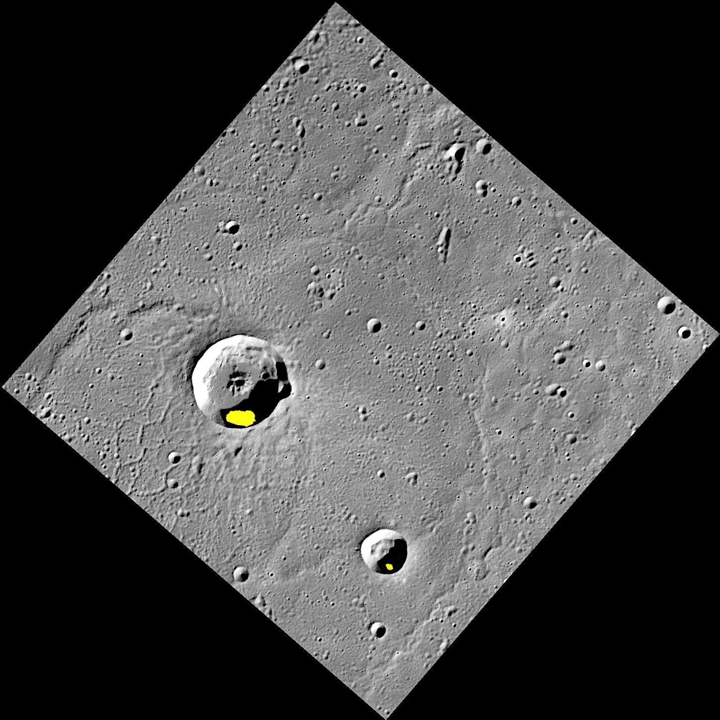
Finding evidence for water ice on the planet closest to the Sun was an exciting discovery, but there is still more to learn about Mercury's icy deposits. Regions of permanent shadow seem to be a requirement for water ice to reside on the Solar System's innermost planet, so the large majority of Mercury's water ice deposits are located within impact craters at high latitudes. The two craters shown here, Egonu and Monk, both appear to have areas of permanent shadow and radar-bright deposits (shown in yellow) that are associated with water ice. However these craters are located a fair distance from Mercury's pole, all the way down at 66° latitude! How long can ice stay in these craters? That is just one of the interesting questions about Mercury's water ice deposits still being investigated.

This image was acquired as part of MDIS's high-resolution surface morphology base map. The surface morphology base map covers more than 99% of Mercury's surface with an average resolution of 200 meters/pixel. Images acquired for the surface morphology base map typically are obtained at off-vertical Sun angles (i.e., high incidence angles) and have visible shadows so as to reveal clearly the topographic form of geologic features.

Date acquired: July 20, 2011
Image Mission Elapsed Time (MET): 219648898
Image ID: 528063
Instrument: Wide Angle Camera (WAC) of the Mercury Dual Imaging System (MDIS)
WAC filter: 7 (748 nanometers)
Center Latitude: 67.29°
Center Longitude: 63.51° E
Resolution: 133 meters/pixel
Scale: Egonu has a diameter of 25 km (16 miles); Monk has a diameter of 13 km (8 miles)
Incidence Angle: 74.5°
Emission Angle: 0.2°
Phase Angle: 74.5°
Arecibo Radar Image: Shown in yellow, from Harmon et al., Icarus, 211, 37-50 (2011)

Image credit: NASA/Johns Hopkins University Applied Physics Laboratory/Carnegie Institution of Washington

Friday, March 15, 2013

A Tribute to Messenger


This video showcases a small sampling of the thousands of images taken by the spacecraft, as well as animations illustrating how MESSENGER moves in orbit and how its orbit has changed during the mission.

The opening sequence is from the approach images from the first flyby in 2008. The first animation to follow (at 0:15) shows MESSENGER in its primary mission 12-hour orbit. The relevance of the November 9, 2011, date is that this was when the MESSENGER team was advised that NASA had approved the proposal for an extended mission, allowing the mission to continue making new observations from March 2012 to March 2013. The animation at 0:22 gives you an idea of the movement and gyrations ("dancing") that the spacecraft undergoes while it performs a schedule packed full of observations that take place over one Earth day. The animation sequence at 0:59 gives you a "top down" view over Mercury's north pole from when MESSENGER first went into orbit until several months into the extended mission. The apparent size of the orbit shrinks from the start of the animation to the end, as shortly into the extended mission, MESSENGER's orbital period was shrunk from 12-hours to 8-hours. The animation sequence at 1:44 shows MESSENGER's "dance" on the first day of the extended mission. The other images and embedded movies can be found in the Gallery section of the MESSENGER website.

Some highlight images of note include:

At 0:48 - Blue rays of Bek crater
At 0:54 - Basho crater
At 0:57 - Poe crater in Caloris basin
At 1:17 - MASCS instrument surface scans in ultraviolet and infrared
At 1:19 - A perspective view of the northern polar region, color-coded to MLA topography
At 1:27 - Rembrandt impact basin
At 1:29 - Rembrandt impact basin superimposed on the US for size comparison
At 1:34 - Rachmaninoff impact basin, 3D effect crated using the digital elevation model
At 1:34 - Debussy crater
At 1:58 - Beagle rupes
At 2:04 - Mosaic view of north pole, showing the shadowed regions
At 2:06 - As previous, with superimposed radar data indicating likely water-ice deposits
At 2:11 - A volcanic vent near the edge of Caloris basin
At 2:34 - Derain crater
At 2:36 - Disney crater and two unnamed craters that resemble Mickey Mouse
At 2:38 - Basho crater while the Sun is low in the sky
At 2:40 - Basho crater again, but now with the Sun nearly overhead
At 2:45 - Degas crater
At 2:58 - 'Weird terrain' at the Caloris antipode
At 3:03 - Waters crater with the 'blue tongue' of dark impact melt material
At 3:10 - Seuss crater
At 3:13 - Caloris basin
At 3:15 - Pit in Scarlatti crater, with prominent hollows on the pit rim
At 3:17 - Enhanced color of Caloris basin
At 3:22 - A lava channel that had flowed into the Kofi crater
At 3:29 - More detail of Caloris basin floor
At 3:30 - The young, bright-rayed Mena crater
At 3:37 - Central peaks of Eminescu crater, with hollows around the bases of the peaks
At 3:39 - Apollodorus and Pantheon fossae
At 3:41 - The hollows on the floor of Sander crater

The MESSENGER spacecraft is the first ever to orbit the planet Mercury, and the spacecraft's seven scientific instruments and radio science investigation are unraveling the history and evolution of the Solar System's innermost planet. Visit the Why Mercury? section of this website to learn more about the key science questions that the MESSENGER mission is addressing. During the one-year primary mission, MDIS acquired 88,746 images and extensive other data sets. MESSENGER is now in a year-long extended mission, during which plans call for the acquisition of more than 80,000 additional images to support MESSENGER's science goals.

Video credit: Images and animation stills courtesy NASA/Johns Hopkins University Applied Physics Laboratory/Carnegie Institution of Washington. Music: "Mercury Ridge" by Simon Wilkinson (thebluemask.com). Video creation and time-lapse animations by Mark 'Indy' Kochte.

Tuesday, February 26, 2013

Chao Meng-Fu Crater


Because of the small axial tilt of Mercury's pole of rotation, several of the craters in this south polar image are shrouded in permanent shadow. Earth-based radar observations have found that these craters also host radar-bright material that is likely water ice. In the furthest southern portion of this image, the rim of the large crater Chao Meng-Fu rises from the darkness.

Date acquired: September 07, 2011
Image Mission Elapsed Time (MET): 223925708
Image ID: 730957
Instrument: Narrow Angle Camera (NAC) of the Mercury Dual Imaging System (MDIS)
Center Latitude: -86.25°
Center Longitude: 303.9° E
Resolution: 268 meters/pixel
Scale: The image is 385 kilometers (239 miles) from corner to corner.
Incidence Angle: 87.9°
Emission Angle: 7.1°
Phase Angle: 80.8°

Photo credit: NASA/Johns Hopkins University Applied Physics Laboratory/Carnegie Institution of Washington

Monday, April 9, 2012

Radar-Bright Deposits in Mercury's North Polar Region


MESSENGER's highly eccentric orbit, which passes low over Mercury's north polar region, enables higher-resolution views of Mercury's surface in the north than in the south. Shown here is a subset of this image; the large 100-km diameter crater in the center is located at 72.5° N, 67.4° E and was recently named Stieglitz, for the American photographer Alfred Stieglitz. Of particular note are the craters hosting radar-bright features at low latitudes, extending southward to 67° N, and the many small craters that host radar-bright deposits. Low-latitude and small craters provide thermally challenging environments for water ice to persist. A thin (few tens of centimeters thick) layer of insulation is likely required to cover and to lower the temperature of these deposits if they are water ice. However, the smallest craters and the lowest-latitude locations may prove a challenge for water ice stability over extended periods of geologic time even with such cover.

Instrument: Wide Angle Camera (WAC) of the Mercury Dual Imaging System (MDIS)

Image credit: NASA/Johns Hopkins University Applied Physics Laboratory/Carnegie Institution of Washington

Note: For a similar image showing a wide-area map of the north polar region, see PIA15530: Radar-bright Deposits near Mercury's North Pole.

Saturday, April 7, 2012

Mercury South Polar Illumination Map


Shown here is an illumination map of Mercury's south polar region. The map is colored on the basis of the percentage of time that a given area is sunlit; areas appearing black in the map are regions of permanent shadow. This map was created by using 89 wide-angle camera (WAC) images of Mercury's south polar region acquired by the Mercury Dual Imaging System (MDIS) over one complete Mercury solar day (176 Earth days) which can be viewed in this movie. Radar-bright deposits, which may be water ice, collocate with regions of permanent shadow.

Scale: The large crater near Mercury's south pole, Chao Meng-Fu, has a diameter of 180 km
Map Information: This illumination map is shown in polar stereographic projection, extending northward to 73° S, and 0° longitude is at the top

Map credit: NASA/Johns Hopkins University Applied Physics Laboratory/Carnegie Institution of Washington/Byrne et al.

Friday, April 6, 2012

Map of Northern Shadows


MESSENGER's highly eccentric orbit passes high above Mercury's south pole and low over Mercury's north polar region. Consequently, unlike for the south, a single WAC image cannot view the entire north polar region. However, more than 6,000 WAC images have been acquired of Mercury's north polar region, providing views under different illumination conditions over two Mercury solar days. These images allow areas to be mapped that are in shadow in all MDIS images to date. This mosaic shows a view of Mercury's north polar region assembled from those images, with areas in shadow shown in red. A small fraction of Mercury's surface near the north pole has yet to be imaged and is the focus of a new imaging campaign in MESSENGER's newly inaugurated extended mission. Radar-bright features near Mercury's north pole, that may be water ice, collocate with shadowed areas.

Instrument: Wide Angle Camera (WAC) of the Mercury Dual Imaging System (MDIS)
Scale: On Mercury, 5° of latitude is approximately 213 km
Map Information: Polar stereographic projection with every 5° of latitude and 30° of longitude indicated and with 0° longitude at the bottom

Map credit: NASA/Johns Hopkins University Applied Physics Laboratory/Carnegie Institution of Washington

Friday, March 30, 2012

Debussy Crater Rays


The beautiful rays of Debussy cross this scene located to the east of the crater. Though not as extensive as those of Hokusai, Debussy's rays extend hundreds of kilometers from the crater. Debussy was first observed as feature "A" in Earth-based radar acquired at the Goldstone Observatory in 1969.

Date acquired: March 14, 2012
Image Mission Elapsed Time (MET): 240247908
Image ID: 1517090
Instrument: Narrow Angle Camera (NAC) of the Mercury Dual Imaging System (MDIS)
Center Latitude: -31.90°
Center Longitude: 28.14° E
Resolution: 99 meters/pixel
Scale: The image is approximately 120 km (75 miles) across
Incidence Angle: 44.2°
Emission Angle: 52.6°
Phase Angle: 28.1°

Photo credit: NASA/Johns Hopkins University Applied Physics Laboratory/Carnegie Institution of Washington