Showing posts with label Impact Basins. Show all posts

Saturday, September 27, 2014

Vivaldi Basin


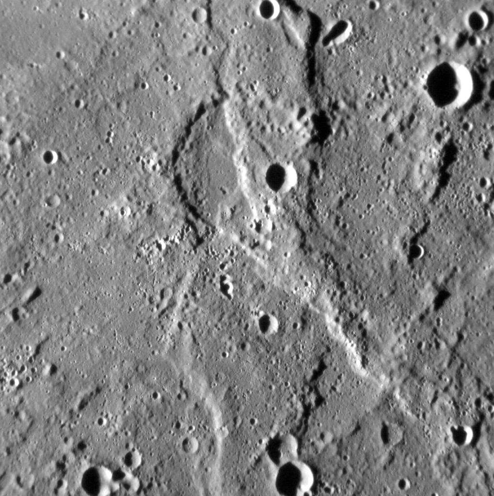
These images highlight the spectacular Vivaldi peak-ring basin and its ejecta blanket. The top image was acquired with MESSENGER's Wide Angle Camera, and the white box shows the location of the bottom image, acquired about a minute later with the Narrow Angle Camera. While Vivaldi is stunning, the real purpose of these images was to check and improve the geometric calibration of the cameras. As light passes through the lenses of a camera, it bends such that subtle geometric distortions of the scene occur, and for the Wide Angle Camera things like the focal length can shift by small amounts depending on which filter is being used. These images were part of a series that is designed to make sure we can map each pixel of the NAC and WAC to a geographic latitude and longitude as accurately as possible, and that the coordinates from the two cameras match perfectly. The two images shown here are also a good reminder of just how much higher resolution the NAC provides compared to the WAC.

Date acquired: July 29, 2014
Image Mission Elapsed Time (MET): 48972719, 48972797
Image ID: 6774306, 6774309
Instrument: Wide Angle Camera (WAC) and Narrow Angle Camera (NAC) of the Mercury Dual Imaging System (MDIS)
Center Latitude: 12.08°
Center Longitude: 278.1° E
Resolution: 57 and 426 meters/pixel
Scale: Vivaldi is approximately 213 km (132 miles) in diameter
Incidence Angle: 82.2°
Emission Angle: 14.3°
Phase Angle: 96.5°

Image credit: NASA/Johns Hopkins University Applied Physics Laboratory/Carnegie Institution of Washington

Tuesday, August 5, 2014

Rembrandt Impact Basin Mineralogical Map


The top image is a MASCS VIRS color composite of Rembrandt, Mercury's second largest impact basin. The bottom image is a MDIS color mosaic of the same area. Rembrandt's rim appears blue in both images, indicating low reflectance relative to its center in the VIRS image. Some small, fresh craters appear in yellow and are highly reflective in VIRS.

The VIRS composite shows hundreds of individual footprints tracks (minimum 100-200 m across and 3-4 km long) taken from different directions and altitudes. In locations where multiple footprints cover the same area, the footprint with the best illumination for mineralogical interpretation (usually the lowest incidence angle where shadows are minimized) is used for making the map.

Date Created: July 27, 2014
Instruments: Visible and Infrared Spectrograph (VIRS) of the Mercury Atmosphere and Surface Composition Spectrometer (MASCS) and Mercury Dual Imaging System (MDIS)
VIRS Color Composite Wavelengths: 575 nm as red, 415 nm/750 nm as green, 310 nm/390 nm as blue
MDIS Color Wavelengths: 1000nm as red, 750nm as green, 430 as blue
Center Latitude: -34.3°
Center Longitude: 87.2° E
Resolution: 1 km/pixel
Scale: Rembrandt is 715 km (444 mi.) in diameter

Image credit: NASA/Johns Hopkins University Applied Physics Laboratory/Carnegie Institution of Washington

Saturday, July 26, 2014

Raditladi Basin


This color view of Raditladi gives us a fresh view of the peak-ring basin. The bright hollows of Raditladi stand out in white along the peak ring against the smooth crater floor. These shallow depressions may result from the loss of volatile materials. Today's image also shows the darker ejecta of a crater that impacted the basin just above the southern peak-ring structure. The darker material was likely excavated during the small crater's impact.

This image was acquired as a targeted high-resolution 11-color image set. Acquiring 11-color targets is a new campaign that began in March 2013 and that utilizes all of the WAC's 11 narrow-band color filters. Because of the large data volume involved, only features of special scientific interest are targeted for imaging in all 11 colors.

Date acquired: June 22, 2014
Image Mission Elapsed Time (MET): 45761752, 45761748, 45761746
Image ID: 6547149, 6547147, 6547146
Instrument: Wide Angle Camera (WAC) of the Mercury Dual Imaging System (MDIS)
WAC filters: 9, 7, 6 (996, 748, 433 nanometers) in red, green, and blue
Center Latitude: 28.37°
Center Longitude: 120.3° E
Resolution: 732 meters/pixel
Scale: Raditladi crater has a diameter of 257.7 km (160.1 miles)
Incidence Angle: 57.3°
Emission Angle: 38.5°
Phase Angle: 89.4°

Image credit: NASA/Johns Hopkins University Applied Physics Laboratory/Carnegie Institution of Washington

Saturday, July 19, 2014

Craters Munch, Sander and Poe


The top image is a MASCS VIRS interpolated color composite of craters Munch and Sander (center), with Poe toward the east. These craters are in the north of Caloris basin. The center image is a MASCS color composite showing individual spectral footprints. The bottom image is a monochrome MDIS mosaic of the same area. The three crater rims are blue, indicating low reflectance. Sander's floor is yellow, however, which is high reflectance and indicative of fresh material.

The VIRS composite shows hundreds of individual footprints tracks (minimum 100-200 m across and 3-4 km long) taken from different directions and altitudes. In locations where multiple footprints cover the same area, the footprint with the best illumination for mineralogical interpretation (usually the lowest incidence angle where shadows are minimized) is used for making the map. In areas where footprints are sparse (separated by tens of km), observations are interpolated for complete coverage of the surface. This is particularly true in the northern hemisphere, where Caloris is located. In the MDIS mosaic, some brightness variations are due to tiling of images taken at different illuminations.

Date Created: June 16, 2014
Instruments: Visible and Infrared Spectrograph (VIRS) of the Mercury Atmosphere and Surface Composition Spectrometer (MASCS) and Mercury Dual Imaging System (MDIS)
VIRS Color Composite Wavelengths: 575 nm as red, 415 nm/750 nm as green, 310 nm/390 nm as blue
Center Latitude: 42.5°
Center Longitude: 154.5° E
Resolution: 1 km/pixel
Scale: Sander crater (center) is about 50 km (31 mi.) in diameter.

Image credit: NASA/Johns Hopkins University Applied Physics Laboratory/Carnegie Institution of Washington

Saturday, June 7, 2014

Sander and Munch Craters


Today's image features a stunning view of two complex craters within the Caloris basin. The floor of Sander crater is covered with bright hollows, while Munch crater stands out due to its low-reflectance crater rim.

This image was acquired as a high-resolution targeted color observation. Targeted color observations are images of a small area on Mercury's surface at resolutions higher than the 1-kilometer/pixel 8-color base map. During MESSENGER's one-year primary mission, hundreds of targeted color observations were obtained. During MESSENGER's extended mission, high-resolution targeted color observations are more rare, as the 3-color base map covered Mercury's northern hemisphere with the highest-resolution color images that are possible.

Date acquired: April 26, 2014
Image Mission Elapsed Time (MET): 40804465, 40804485, 40804469
Image ID: 6194731, 6194736, 6194732
Instrument: Wide Angle Camera (WAC) of the Mercury Dual Imaging System (MDIS)
WAC filters: 9, 7, 6 (996, 748, 433 nanometers) in red, green, and blue
Center Latitude: 39.98°
Center Longitude: 153.1° E
Resolution: 290 meters/pixel
Scale: Sander crater is about 51 km (31.7 miles) in diameter
Incidence Angle: 46.9°
Emission Angle: 50.5°
Phase Angle: 79.7°

Image credit: NASA/Johns Hopkins University Applied Physics Laboratory/Carnegie Institution of Washington

Saturday, May 31, 2014

Hollow Inside Ahmad Baba Basin


MESSENGER was just 184 km above Mercury's surface when it snapped this view of a hollow in Ahmad Baba crater. The hollow is located on the south-facing slope of Ahmad Baba's peak ring (north is toward the upper-right corner in this image).

This image was acquired as part of the MDIS low-altitude imaging campaign. During MESSENGER's second extended mission, the spacecraft makes a progressively closer approach to Mercury's surface than at any previous point in the mission, enabling the acquisition of high-spatial-resolution data. For spacecraft altitudes below 350 kilometers, NAC images are acquired with pixel scales ranging from 20 meters to as little as 2 meters.

Date acquired: May 12, 2014
Image Mission Elapsed Time (MET): 42186174
Image ID: 6293058
Instrument: Narrow Angle Camera (NAC) of the Mercury Dual Imaging System (MDIS)
Center Latitude: 57.60°
Center Longitude: 231.5° E
Resolution: 6 meters/pixel
Scale: This image is approximately 7 km (4 miles) across
Incidence Angle: 70.8°
Emission Angle: 49.0°
Phase Angle: 80.0°

Image credit: NASA/Johns Hopkins University Applied Physics Laboratory/Carnegie Institution of Washington

Tuesday, May 27, 2014

Raditladi Basin Troughs


The troughs of Raditladi are the focus of this high-resolution view inside the peak-ring basin. The troughs, which are largely concentric to the basin, formed through extensional stresses that caused portions of the floor to pull apart. Such extensional features are similar to those observed within Caloris. Some of the small, bright craters that dot Raditladi's floor may be secondaries from Fonteyn crater approximately 900 km away, whose rays appear to cross the basin.

This image was acquired as a high-resolution targeted observation. Targeted observations are images of a small area on Mercury's surface at resolutions much higher than the 200-meter/pixel morphology base map. It is not possible to cover all of Mercury's surface at this high resolution, but typically several areas of high scientific interest are imaged in this mode each week.

Date acquired: April 30, 2014
Image Mission Elapsed Time (MET): 41150312
Image ID: 6219297
Instrument: Narrow Angle Camera (NAC) of the Mercury Dual Imaging System (MDIS)
Center Latitude: 27.79°
Center Longitude: 119.4° E
Resolution: 38 meters/pixel
Scale: This scene is approximately 46 km (29 miles) across
Incidence Angle: 63.9°
Emission Angle: 33.0°
Phase Angle: 97.0°

Image credit: NASA/Johns Hopkins University Applied Physics Laboratory/Carnegie Institution of Washington

Wednesday, April 30, 2014

Scarp Near the Western Edge of Rembrandt Basin


Today's image is located on the western edge of the Rembrandt basin. A scarp cuts right through a pair of older impact craters, leaving them deformed. This image is an anaglyph, which creates a 3D effect when viewed through a pair of red-cyan glass. If you've found a pair of glasses, check out these other 3D views created with MESSENGER images.

This image was acquired as a targeted set of stereo images. Targeted stereo observations are acquired at resolutions much higher than that of the 200-meter/pixel stereo base map. These targets acquired with the NAC enable the detailed topography of Mercury's surface to be determined for a local area of interest.

Date acquired: August 13, 2013
Image Mission Elapsed Time (MET): 18733660, 18734492
Image ID: 4625953, 4625956
Instrument: Narrow Angle Camera (NAC) of the Mercury Dual Imaging System (MDIS)
Center Latitude: -37.6°
Center Longitude: 79.15° E
Resolution: 100 meters/pixel
Scale: This image is roughly 90 kilometers across (56 miles)
Incidence Angle: 81.0°, 81.0°
Emission Angle: 0.3°, 19.9°
Phase Angle: 81.2°, 81.9°
Orientation: North is to the right to enhance the 3D effect.

Image credit: NASA/Johns Hopkins University Applied Physics Laboratory/Carnegie Institution of Washington

Saturday, March 22, 2014

Mercury by Messenger's MASCS and VIRS Instruments


The Sun's light provides a powerful tool for understanding the composition of materials in the Solar System. Today's image features two views of Mercury provided by the Mercury Atmospheric and Surface Composition Spectrometer (MASCS) instrument. As the Sun's light hits the surface of Mercury, the Visible and Infrared Spectrograph (VIRS) portion of MASCS measures many wavelengths of the reflected light from a single spot on the surface at a time. These observations create a spectral profile of the surface as MESSENGER orbits Mercury. In each panel, the top left corner of the image is 70°N,180°E and the bottom right corner is 70°S,180°E. Most of Caloris basin can be seen along the right edge of each panel. The top panel is a monochromatic image of the interpolated 750 nm reflectance, and the bottom panel shows the same data but in a false color composite selected to highlight compositional variations on the surface.

The monochromatic map is part of a data set that was released to the public earlier this month through the Planetary Data System (PDS). In conjunction with the release, the team hosted a Data User's Workshop at the 45th Lunar and Planetary Science Conference, which is being held this week in The Woodlands, Texas.

Instruments: Visible and Infrared Spectrograph (VIRS) of the Mercury Atmosphere and Surface Composition Spectrometer (MASCS)
Center Latitude:
Center Longitude: 0° E
Map Projection: Simple Cylindrical
VIRS Monochromatic Wavelength: 750 nm
VIRS Color Composite Wavelengths: 575 nm as red, 415 nm/750 nm as green, 310 nm/390 nm as blue
Scale: Caloris Basin is 1,550 km (963 mi) across.

Image credit: NASA/Johns Hopkins University Applied Physics Laboratory/Carnegie Institution of Washington

Thursday, March 6, 2014

Caloris Basin Rim


Small knobs and crater rims just barely catch the sunlight with the Sun low on Mercury's eastern horizon. The relatively smooth floor of the Caloris basin is on the right, and the rim and exterior of the basin are to the left. The knobby texture outside of the basin may be the result of blocks of material that were ejected by the basin-forming impact.

This image was acquired as part of MDIS's high-incidence-angle base map. The high-incidence-angle base map complements the surface morphology base map of MESSENGER's primary mission that was acquired under generally more moderate incidence angles. High incidence angles, achieved when the Sun is near the horizon, result in long shadows that accentuate the small-scale topography of geologic features. The high-incidence-angle base map was acquired with an average resolution of 200 meters/pixel.

Date acquired: April 27, 2012
Image Mission Elapsed Time (MET): 244054579
Image ID: 1721895
Instrument: Wide Angle Camera (WAC) of the Mercury Dual Imaging System (MDIS)
WAC filter: 7 (748 nanometers)
Center Latitude: 40.19°
Center Longitude: 140.5° E
Resolution: 270 meters/pixel
Scale: This scene is approximately 492 km (306 miles) across
Incidence Angle: 88.2°
Emission Angle: 53.7°
Phase Angle: 142.0°

Photo credit: NASA/Johns Hopkins University Applied Physics Laboratory/Carnegie Institution of Washington

Saturday, March 1, 2014

Graben from Pantheon Fossae


A series of troughs extends diagonally (southwest-northeast) across this high-resolution image of the interior of the Caloris basin. The troughs are graben: structures that developed where horizontal forces pulled the crust apart, causing valleys to form as sections of rock dropped down between two inward-dipping faults. Pulling-apart ("extensional") deformation is much less common on Mercury than is compressional deformation. However, a large number of graben are found within Caloris. This network of graben, named Pantheon Fossae, is the subject of a blog essay recently posted on the website of The Planetary Society.

This image was acquired as a high-resolution targeted observation. Targeted observations are images of a small area on Mercury's surface at resolutions much higher than the 200-meter/pixel morphology base map. It is not possible to cover all of Mercury's surface at this high resolution, but typically several areas of high scientific interest are imaged in this mode each week.

Date acquired: January 19, 2012
Image Mission Elapsed Time (MET): 235472082
Image ID: 1285755
Instrument: Narrow Angle Camera (NAC) of the Mercury Dual Imaging System (MDIS)
Center Latitude: 27.3°
Center Longitude: 160.7° E
Resolution: 24 meters/pixel
Scale: The scene is about 43 km (27 mi.) across
Incidence Angle: 76.8°
Emission Angle: 54.9°
Phase Angle: 131.8°
North is up in this image.

Photo credit: NASA/Johns Hopkins University Applied Physics Laboratory/Carnegie Institution of Washington

Tuesday, February 11, 2014

Dürer Peak-Ring Basin


This image, taken at a high emission angle, helps the eye to see the three-dimensional nature of the scene. Dürer, a peak-ring basin, can be seen in the foreground. Dürer's peak ring is dotted with hollows. North is to the left in this image.

This image was acquired as part of MDIS's high-incidence-angle base map. The high-incidence-angle base map complements the surface morphology base map of MESSENGER's primary mission that was acquired under generally more moderate incidence angles. High incidence angles, achieved when the Sun is near the horizon, result in long shadows that accentuate the small-scale topography of geologic features. The high-incidence-angle base map was acquired with an average resolution of 200 meters/pixel.

Date acquired: November 16, 2013
Image Mission Elapsed Time (MET): 26946160
Image ID: 5209643
Instrument: Wide Angle Camera (WAC) of the Mercury Dual Imaging System (MDIS)
WAC filter: 7 (748 nanometers)
Center Latitude: 20.68°
Center Longitude: 244.9° E
Resolution: 236 meters/pixel
Scale: Dürer basin is approximately 195 km (121 mi.) in diameter.
Incidence Angle: 67.1°
Emission Angle: 62.9°
Phase Angle: 30.0°

Photo credit: NASA/Johns Hopkins University Applied Physics Laboratory/Carnegie Institution of Washington

Thursday, February 6, 2014

Hollows in an Unnamed Impact Crater


Today's image features the central peak complex of a large, unnamed crater on the plains surrounding the Caloris basin, roughly 400 km (250 mi) northwest of the crater Munch. The image has been stretched to highlight the details of the hollows that are forming on the crests of the peaks. The bright hollows on Mercury stand out in stark contrast to the low reflectance material with which they are frequently associated.

This image was acquired as a high-resolution targeted observation. Targeted observations are images of a small area on Mercury's surface at resolutions much higher than the 200-meter/pixel morphology base map. It is not possible to cover all of Mercury's surface at this high resolution, but typically several areas of high scientific interest are imaged in this mode each week.

Date acquired: July 05, 2011
Image Mission Elapsed Time (MET): 218374017
Image ID: 466629
Instrument: Narrow Angle Camera (NAC) of the Mercury Dual Imaging System (MDIS)
Center Latitude: 47.45°
Center Longitude: 145.6° E
Resolution: 30 meters/pixel
Scale: The image is about 31 km (19 mi.) wide
Incidence Angle: 48.0°
Emission Angle: 5.6°
Phase Angle: 53.7°

Photo credit: NASA/Johns Hopkins University Applied Physics Laboratory/Carnegie Institution of Washington

Saturday, February 1, 2014

Kertesz Crater


The hollows-covered floor of Kertesz, located near the center of this image, distinguishes it from the other craters in this enhanced-color scene. A 3-kilometer crater also features prominently in this image despite its small size, due to its extensive set of young, bright rays. Both of these features are located on the floor of the great Caloris basin, which is a host to a variety of interesting tectonic features, including the troughs visible on the east side of this image.

This image was acquired as a high-resolution targeted color observation. Targeted color observations are images of a small area on Mercury's surface at resolutions higher than the 1-kilometer/pixel 8-color base map. During MESSENGER's one-year primary mission, hundreds of targeted color observations were obtained. During MESSENGER's extended mission, high-resolution targeted color observations are more rare, as the 3-color base map covered Mercury's northern hemisphere with the highest-resolution color images that are possible.

Date acquired: November 01, 2013
Image Mission Elapsed Time (MET): 25622919, 25622939, 25622923
Image ID: 5115429, 5115434, 5115430
Instrument: Wide Angle Camera (WAC) of the Mercury Dual Imaging System (MDIS)
WAC filters: 9, 7, 6 (996, 748, 433 nanometers) in red, green, and blue
Center Latitude: 27.16°
Center Longitude: 146.1° E
Resolution: 272 meters/pixel
Scale: Kertesz has a diameter of 32 kilometers (20 miles)
Incidence Angle: 42.4°
Emission Angle: 36.9°
Phase Angle: 78.2°

Photo credit: NASA/Johns Hopkins University Applied Physics Laboratory/Carnegie Institution of Washington

Saturday, January 25, 2014

Tolstoj Basin and Nureyev Crater


The Tolstoj basin (355 km in diameter) can be seen at the bottom edge of the frame, its center filled with smooth plains and surrounded by a large region of low-reflectance ejecta. The fresh, bright-rayed crater Nureyev is visible near the limb.

This image was acquired as part of MDIS's limb imaging campaign. Once per week, MDIS captures images of Mercury's limb, with an emphasis on imaging the southern hemisphere limb. These limb images provide information about Mercury's shape and complement measurements of topography made by the Mercury Laser Altimeter (MLA) of Mercury's northern hemisphere.

Date acquired: November 21, 2013
Image Mission Elapsed Time (MET): 27346412
Image ID: 5238318
Instrument: Wide Angle Camera (WAC) of the Mercury Dual Imaging System (MDIS)
WAC filter: 7 (748 nanometers)
Center Latitude: -4.37°
Center Longitude: 188.8° E
Resolution: 1015 meters/pixel
Incidence Angle: 14.6°
Emission Angle: 58.8°
Phase Angle: 63.2°

Photo credit: NASA/Johns Hopkins University Applied Physics Laboratory/Carnegie Institution of Washington

Tuesday, January 14, 2014

Lobate Scarp in Rembrandt Basin


The Rembrandt basin is the second-largest well preserved impact structure on Mercury, and is one of the best examples of a process that has irrevocably shaped the surface of the innermost planet. Yet the planet has been fundamentally shaped by another process -- global contraction -- that has resulted in the formation of lobate scarps and wrinkle ridges across the surface of Mercury.

In this image, we see a good example of where these processes meet. The most prominent landform in the scene is a north-west-trending scarp, its eastern margin illuminated by the Sun. Scarps such as this form when one portion of Mercury's crust thrusts up over another, the result of crustal shortening in response to the planet's volume decreasing as its interior cools. Yet if you look carefully, you might spy an alignment in the texture of the surface here, trending from the bottom-left to the top-right of the image. This alignment is due to radial scouring of the surface around Rembrandt by debris thrown out during the impact that formed the basin.

This image was acquired as a high-resolution targeted observation. Targeted observations are images of a small area on Mercury's surface at resolutions much higher than the 200-meter/pixel morphology base map. It is not possible to cover all of Mercury's surface at this high resolution, but typically several areas of high scientific interest are imaged in this mode each week.

Date acquired: November 5, 2013
Image Mission Elapsed Time (MET): 25999800
Image ID: 5142079
Instrument: Narrow Angle Camera (NAC) of the Mercury Dual Imaging System (MDIS)
Center Latitude: -20.99°
Center Longitude: 100.55° E
Resolution: 115 meters/pixel
Scale: The field of view in this image is about 120 km (75 mi.) across
Incidence Angle: 79.4°
Emission Angle: 12.2°
Phase Angle: 67.2°
North is to the bottom of the image.

Image credit: NASA/Johns Hopkins University Applied Physics Laboratory/Carnegie Institution of Washington

Friday, November 22, 2013

Rough Ejecta Terrain Near Mozart Impact Basin


Wolfgang's namesake basin has had a large effect on Mercury. Ejecta from the 241-kilometer-diameter (150 mile) impact basin has left an enormous network of rough terrain, in beautiful contrast to the basin's smooth interior. Mozart basin lies just a hop, skip and a jump away from the planet's largest impact basin, Caloris.

This image was acquired as a high-resolution targeted observation. Targeted observations are images of a small area on Mercury's surface at resolutions much higher than the 200-meter/pixel morphology base map. It is not possible to cover all of Mercury's surface at this high resolution, but typically several areas of high scientific interest are imaged in this mode each week.

Date acquired: October 02, 2013
Image Mission Elapsed Time (MET): 22999301
Image ID: 4929063
Instrument: Narrow Angle Camera (NAC) of the Mercury Dual Imaging System (MDIS)
Center Latitude: 12.52°
Center Longitude: 168.0° E
Resolution: 47 meters/pixel
Scale: The entire image is approximately 95 km (59 mi.) across.
Incidence Angle: 78.9°
Emission Angle: 59.6°
Phase Angle: 138.5°
North is down in this image.

Photo credit: NASA/Johns Hopkins University Applied Physics Laboratory/Carnegie Institution of Washington

Thursday, November 14, 2013

Hollows and Pyroclastic Deposits in a Crater Near Caloris Basin


Today's image features several craters near the eastern edge of the Caloris basin. The larger craters have excavated low reflectance material, and both have hollows forming within their floors. Reddish deposits that exhibit a spectral signature similar to pyroclastics occur in the northeastern quadrant of this scene, suggesting that this region may have once been the site of explosive volcanism.

This image was acquired as a targeted high-resolution 11-color image set. Acquiring 11-color targets is a new campaign that began in March 2013 and that utilizes all of the WAC's 11 narrow-band color filters. Because of the large data volume involved, only features of special scientific interest are targeted for imaging in all 11 colors.

Date acquired: October 24, 2013
Image Mission Elapsed Time (MET): 24470528, 24960452, 24470516
Image ID: 5033545, 5068359, 5033542
Instrument: Wide Angle Camera (WAC) of the Mercury Dual Imaging System (MDIS)
WAC filters: 9, 7, 6 (996, 748, 433 nanometers) in red, green, and blue
Center Latitude: 23.72°
Center Longitude: 179.1° E
Resolution: 260 meters/pixel
Scale: The larger crater near the top of the image is approximately 54 km (33.5 mi.) in diameter.
Incidence Angle: 24.8°
Emission Angle: 8.4°
Phase Angle: 33.2°

Photo credit: NASA/Johns Hopkins University Applied Physics Laboratory/Carnegie Institution of Washington

Sunday, November 10, 2013

Ride Along With Messenger (Video 2)


This movie was assembled from 289 individual NAC images. Most of the images were acquired four seconds apart, the fastest that MDIS is capable of taking full resolution images, but this movie is shown with 15 images per second. The movie begins centered on the 191-km diameter Schubert basin.

These images were acquired as part of the NAC ride-along imaging campaign. When data volume is available and MDIS is not acquiring images for its other campaigns, high-resolution NAC images are obtained of the surface. These images are designed not to interfere with other instrument observations but take full advantage of periods during the mission when extra data volume is available.

Date acquired: October 04, 2013
Image Mission Elapsed Time (MET): 23236906-23238062
Image ID: 4945775-4946063
Instrument: Narrow Angle Camera (NAC) of the Mercury Dual Imaging System (MDIS)
Initial Center Latitude: -42.67°
Initial Center Longitude: 306.1° E
Final Center Latitude: -50.20°
Final Center Longitude: 311.9° E
Resolution: 176-199 meters/pixel
Scale: The first image is 179 kilometers (111 miles) across
Incidence Angle: 74.3°-79.9°
Emission Angle: 3.6°-0.8°
Phase Angle: 77.9°-79.4°

Video credit: NASA/Johns Hopkins University Applied Physics Laboratory/Carnegie Institution of Washington

Saturday, October 26, 2013

Southwestern Rim of Caloris Basin


This image shows an area of the southwestern rim of the Caloris impact basin. The small hills in the lower left are part of the rim units, and the smooth surface to the right is part of the smooth plains within the basin. The scene lies right on a color boundary between darker rim material and higher-reflectance plains. Small hollows are found on the top of the hills, and small lobate scarps cross the area. The famous kidney-shaped pyroclastic vent is just to the east (right), out of the scene.

This image was acquired as a high-resolution targeted observation. Targeted observations are images of a small area on Mercury's surface at resolutions much higher than the 200-meter/pixel morphology base map. It is not possible to cover all of Mercury's surface at this high resolution, but typically several areas of high scientific interest are imaged in this mode each week.

Date acquired: July 03, 2013
Image Mission Elapsed Time (MET): 15137794
Image ID: 4370103
Instrument: Narrow Angle Camera (NAC) of the Mercury Dual Imaging System (MDIS)
Center Latitude: 22.04°
Center Longitude: 143.6° E
Resolution: 42 meters/pixel
Scale: The scene is about 57 km (35 mi.) across
Incidence Angle: 68.7°
Emission Angle: 31.8°
Phase Angle: 100.1°
North is up in this image.

Photo credit: NASA/Johns Hopkins University Applied Physics Laboratory/Carnegie Institution of Washington