Showing posts with label Water on Mercury. Show all posts

Thursday, August 14, 2014

Simple Crater on Rikyu Crater's Rim


Rikyü is an impact crater named for Sen no Rikyü, the master who was central in the development of the Japanese tea ceremony. Rikyü sits in Mercury's northern plains and is expected to host water ice because of its persistently shadowed interior and radar-bright signature. Today's image features a northwestern segment of the crater wall, where a 4.1 km-wide simple crater has resulted from an impact on Rikyü's rim. This high-resolution image also provides a fantastic view of the tiny craters that mark the crater's wall.

This image was acquired as a high-resolution targeted observation. Targeted observations are images of a small area on Mercury's surface at resolutions much higher than the 200-meter/pixel morphology base map. It is not possible to cover all of Mercury's surface at this high resolution, but typically several areas of high scientific interest are imaged in this mode each week.

Date acquired: August 04, 2012
Image Mission Elapsed Time (MET): 252610116
Image ID: 2330144
Instrument: Narrow Angle Camera (NAC) of the Mercury Dual Imaging System (MDIS)
Center Latitude: 80.17°
Center Longitude: 335.4° E
Resolution: 13 meters/pixel
Scale: The simple crater in the lower left corner is approximately 4.1 km wide (2.5 miles)
Incidence Angle: 82.8°
Emission Angle: 44.8°
Phase Angle: 127.6°

Image credit: NASA/Johns Hopkins University Applied Physics Laboratory/Carnegie Institution of Washington

Saturday, April 26, 2014

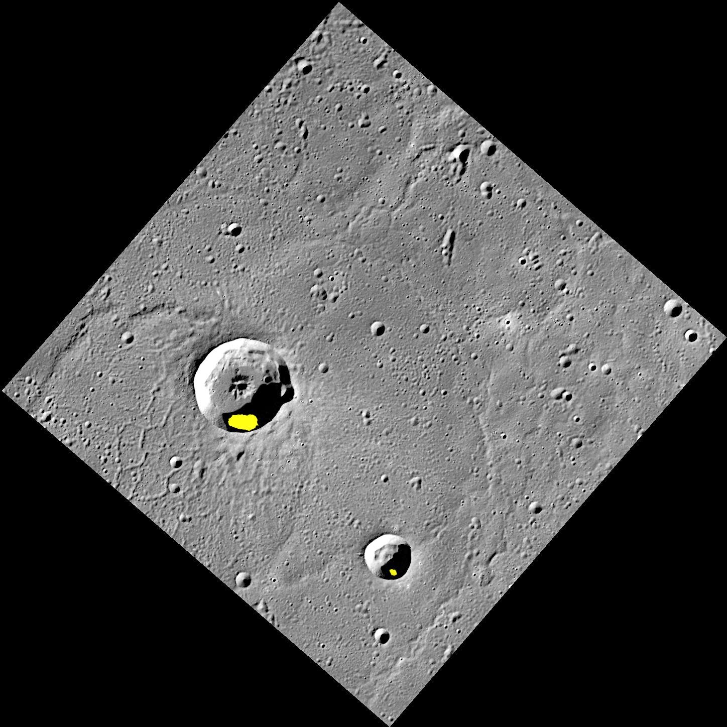
Possible Ice Deposits in Egonu and Monk Craters


Finding evidence for water ice on the planet closest to the Sun was an exciting discovery, but there is still more to learn about Mercury's icy deposits. Regions of permanent shadow seem to be a requirement for water ice to reside on the Solar System's innermost planet, so the large majority of Mercury's water ice deposits are located within impact craters at high latitudes. The two craters shown here, Egonu and Monk, both appear to have areas of permanent shadow and radar-bright deposits (shown in yellow) that are associated with water ice. However these craters are located a fair distance from Mercury's pole, all the way down at 66° latitude! How long can ice stay in these craters? That is just one of the interesting questions about Mercury's water ice deposits still being investigated.

This image was acquired as part of MDIS's high-resolution surface morphology base map. The surface morphology base map covers more than 99% of Mercury's surface with an average resolution of 200 meters/pixel. Images acquired for the surface morphology base map typically are obtained at off-vertical Sun angles (i.e., high incidence angles) and have visible shadows so as to reveal clearly the topographic form of geologic features.

Date acquired: July 20, 2011
Image Mission Elapsed Time (MET): 219648898
Image ID: 528063
Instrument: Wide Angle Camera (WAC) of the Mercury Dual Imaging System (MDIS)
WAC filter: 7 (748 nanometers)
Center Latitude: 67.29°
Center Longitude: 63.51° E
Resolution: 133 meters/pixel
Scale: Egonu has a diameter of 25 km (16 miles); Monk has a diameter of 13 km (8 miles)
Incidence Angle: 74.5°
Emission Angle: 0.2°
Phase Angle: 74.5°
Arecibo Radar Image: Shown in yellow, from Harmon et al., Icarus, 211, 37-50 (2011)

Image credit: NASA/Johns Hopkins University Applied Physics Laboratory/Carnegie Institution of Washington
Thursday, April 25, 2013

Peak of (Almost) Eternal Light


Studies of the illumination conditions near the north and south poles of Mercury are of interest because they can be used to determine locations of permanent shadow, extremely cold places where ice deposits lurk. However, the illumination maps also reveal the locations that receive the maximum duration of sunlight during a Mercury solar day. A "peak of eternal light" that is illuminated continuously for an entire solar day would be a favorable target for a lander, because solar power would be available all the time. So far, no such peak of eternal light has been identified at Mercury's south pole. The spot that get the most illumination (about 82%), is located at 89° S, 50.7° E. This place is indicated by the arrow in today's image.

This image was acquired as part of MDIS's campaign to monitor the south polar region of Mercury. By imaging the polar region approximately every four MESSENGER orbits as illumination conditions change, features that were in shadow on earlier orbits can be discerned and any permanently shadowed areas can be identified after repeated imaging over one solar day. During MESSENGER's one-year primary mission, MDIS's WAC was used to monitor the south polar region for the first Mercury solar day (176 Earth days), and MDIS's NAC made repeated images of the south polar region during the second Mercury solar day.

Date acquired: December 24, 2011
Image Mission Elapsed Time (MET): 233190744
Image ID: 1175166
Instrument: Narrow Angle Camera (NAC) of the Mercury Dual Imaging System (MDIS)
Center Latitude: -88.17°
Center Longitude: 35.40° E
Resolution: 298 meters/pixel
Scale: The large crater is Chao Meng-Fu, about 129 km (80 mi.) in diameter.
Incidence Angle: 91.1°
Emission Angle: 7.1°
Phase Angle: 95.6°
Projection: Polar stereographic projection centered at 90° S, with
0° toward the top and 180° toward the bottom.

Photo credit: NASA/Johns Hopkins University Applied Physics Laboratory/Carnegie Institution of Washington

Saturday, April 20, 2013

Hurley and L'Engle Craters


Repeat imaging of Mercury's south pole has revealed that a number of craters in the south contain permanently shadowed regions. Because Mercury has only a very small axial tilt, the topography of crater rims, as accentuated in the inset image (shown with five times the vertical exaggeration of the actual topography), blocks sunlight from ever reaching portions of the floors of some polar craters.

This image features two such permanently shadowed craters which were recently named. Hurley crater, named for Australian James Francis Hurley (1885-1962), photographer of the famous Shackleton Expedition to Antarctica, is 67 km (42 mi.) wide and located within 3° of Mercury's south pole. The slightly smaller (62 km or 39 mi. wide) L'Engle crater is located to the east of Hurley. (Note that in the inset perspective image the view is towards the south). L'Engle crater is named for American author Madeleine L'Engle (1918-2007), best known for her young-adult novels including 'A Wrinkle in Time'. 'A Wrinkle in Time' blends adventure with quantum physics as it follows young heroine Meg on her journey through space to rescue her scientist father.

This primary image was acquired as part of MDIS's campaign to monitor the south polar region of Mercury. By imaging the polar region approximately every four MESSENGER orbits as illumination conditions change, features that were in shadow on earlier orbits can be discerned and any permanently shadowed areas can be identified after repeated imaging over one solar day. During MESSENGER's one-year primary mission, MDIS's WAC was used to monitor the south polar region for the first Mercury solar day (176 Earth days), and MDIS's NAC made repeated images of the south polar region during the second Mercury solar day. The inset image is a portion of the MDIS monochrome map draped over the Gaskell digital elevation model (with 5 times vertical exaggeration), as was also done for Monday's featured image.

Date acquired: August 03, 2011
Image Mission Elapsed Time (MET): 220899377
Image ID: 587366
Instrument: Wide Angle Camera (WAC) of the Mercury Dual Imaging System (MDIS)
WAC filter: 7 (748 nanometers)
Center Latitude: -85.07°
Center Longitude: 67.57° E
Scale: The inset box is about 280 km (174 mi.) wide
Incidence Angle: 85.0°
Emission Angle: 23.4°
Phase Angle: 94.8°

Photo credit: NASA/Johns Hopkins University Applied Physics Laboratory/Carnegie Institution of Washington

Tuesday, April 16, 2013

Lovecraft and Roerich Craters


Today's image features a perspective view of two of the newly named craters near Mercury's south pole. To create this image, a portion of the MDIS monochrome basemap was draped over a digital elevation model. The topography has been exaggerated by 7 times to accentuate the rugged terrain formed by numerous overlapping craters.

In the foreground, sunlight highlights much of the rim of the dark Lovecraft crater, named for the American horror author Howard Phillips Lovecraft (1890-1937). The larger Roerich crater, named for the Russian painter Nicholas Roerich (1874-1947), lies slightly to the north of Lovecraft crater. One of Lovecraft's most famous works, 'At the Mountains of Madness' takes place on a scientific expedition to the south pole, and references Roerich's artwork--in particular, his paintings of the Tibetan plateau and the Himalayan Mountains. Portions of Lovecraft crater are shrouded in permanent darkness, and host radar-bright material. Similar deposits at the north pole have been associated with water ice and unusually dark material.

Instrument: Mercury Dual Imaging System (MDIS)
Center Latitude: -85.10°
Center Longitude: 284.8° E
Basemap Resolution: approximately 250 meters/pixel
Digital Elevation Model: Produced by MESSENGER Participating Scientist Bob Gaskell based on MDIS images
Vertical Exaggeration: 7 times actual
Scale: Roerich crater is 111.7 km (69.4 miles) across.

Image credit: NASA/Johns Hopkins University Applied Physics Laboratory/Carnegie Institution of Washington

Wednesday, April 10, 2013

Topographical Map of Mercury's Northern Polar Region


This view of the topography of Mercury's north polar region complements yesterday's image of the day (PIA16950). Both were used during The Challenge of Discovery Educator Workshop, which was held last weekend. Workshop participants learned about MESSENGER's recent evidence for water ice near Mercury's poles through an activity that explored different datasets of Mercury's north polar region. Those activity materials can be viewed and download from this workshop website. In this view, MLA tracks across the surface are colored by the height of the surface relative to a reference sphere with a radius of 2440 kilometers.

Instrument: Mercury Laser Altimeter (MLA)
Center Latitude: 90° N
Map Projection: Polar stereographic projection, extending southward to 65° N, with 0° longitude at the bottom
Scale: The diameter of this polar map projection covers 2,130 kilometers (1320 miles)

Map credit: NASA/Johns Hopkins University Applied Physics Laboratory/Carnegie Institution of Washington

Tuesday, April 9, 2013

Orbital Mosaic of Mercury's North Pole


Last weekend, MESSENGER team members participated in The Challenge of Discovery Educator Workshop. Held simultaneously at four locations across the United States, participants learned about MESSENGER's recent evidence for water ice near Mercury's poles. The view shown above is a mosaic of Mercury's north polar region, created from thousands of MDIS images obtained over MESSENGER's >2 years of orbital operations. It was part of an activity at the weekend's workshop, where different datasets from Mercury's north polar region were explored. View this workshop website to see and download other views of Mercury's north polar region.

Instrument: Wide Angle Camera (WAC) of the Mercury Dual Imaging System (MDIS)
Center Latitude: 90° N
Map Projection: Polar stereographic projection, extending southward to 65° N, with 0° longitude at the bottom
Scale: The diameter of this polar map projection covers 2,130 kilometers (1320 miles)

Map credit: NASA/Johns Hopkins University Applied Physics Laboratory/Carnegie Institution of Washington

Tuesday, February 26, 2013

Chao Meng-Fu Crater


Because of the small axial tilt of Mercury's pole of rotation, several of the craters in this south polar image are shrouded in permanent shadow. Earth-based radar observations have found that these craters also host radar-bright material that is likely water ice. In the furthest southern portion of this image, the rim of the large crater Chao Meng-Fu rises from the darkness.

Date acquired: September 07, 2011
Image Mission Elapsed Time (MET): 223925708
Image ID: 730957
Instrument: Narrow Angle Camera (NAC) of the Mercury Dual Imaging System (MDIS)
Center Latitude: -86.25°
Center Longitude: 303.9° E
Resolution: 268 meters/pixel
Scale: The image is 385 kilometers (239 miles) from corner to corner.
Incidence Angle: 87.9°
Emission Angle: 7.1°
Phase Angle: 80.8°

Photo credit: NASA/Johns Hopkins University Applied Physics Laboratory/Carnegie Institution of Washington

Saturday, February 23, 2013

Prokofiev Crater


Prokofiev, named in August 2012 for the Russian composer, is the largest crater in Mercury's north polar region to host radar-bright material. MESSENGER has found evidence that within the cold, dark, permanently shadowed regions of Prokofiev, water ice is exposed on the surface.

Date acquired: January 07, 2013
Image Mission Elapsed Time (MET): 266090610
Image ID: 3288616
Instrument: Wide Angle Camera (WAC) of the Mercury Dual Imaging System (MDIS)
WAC filter: 2 (700 nanometers)
Center Latitude: 84.90°
Center Longitude: 68.75° E
Resolution: 79 meters/pixel
Scale: Prokofiev has a diameter of 112 kilometers (70 miles).
Incidence Angle: 84.9°
Emission Angle: 6.1°
Phase Angle: 78.8°

Photo credit: NASA/Johns Hopkins University Applied Physics Laboratory/Carnegie Institution of Washington

Monday, April 9, 2012

Radar-Bright Deposits in Mercury's North Polar Region


MESSENGER's highly eccentric orbit, which passes low over Mercury's north polar region, enables higher-resolution views of Mercury's surface in the north than in the south. Shown here is a subset of this image; the large 100-km diameter crater in the center is located at 72.5° N, 67.4° E and was recently named Stieglitz, for the American photographer Alfred Stieglitz. Of particular note are the craters hosting radar-bright features at low latitudes, extending southward to 67° N, and the many small craters that host radar-bright deposits. Low-latitude and small craters provide thermally challenging environments for water ice to persist. A thin (few tens of centimeters thick) layer of insulation is likely required to cover and to lower the temperature of these deposits if they are water ice. However, the smallest craters and the lowest-latitude locations may prove a challenge for water ice stability over extended periods of geologic time even with such cover.

Instrument: Wide Angle Camera (WAC) of the Mercury Dual Imaging System (MDIS)

Image credit: NASA/Johns Hopkins University Applied Physics Laboratory/Carnegie Institution of Washington

Note: For a similar image showing a wide-area map of the north polar region, see PIA15530: Radar-bright Deposits near Mercury's North Pole.

Saturday, April 7, 2012

Mercury South Polar Illumination Map


Shown here is an illumination map of Mercury's south polar region. The map is colored on the basis of the percentage of time that a given area is sunlit; areas appearing black in the map are regions of permanent shadow. This map was created by using 89 wide-angle camera (WAC) images of Mercury's south polar region acquired by the Mercury Dual Imaging System (MDIS) over one complete Mercury solar day (176 Earth days) which can be viewed in this movie. Radar-bright deposits, which may be water ice, collocate with regions of permanent shadow.

Scale: The large crater near Mercury's south pole, Chao Meng-Fu, has a diameter of 180 km
Map Information: This illumination map is shown in polar stereographic projection, extending northward to 73° S, and 0° longitude is at the top

Map credit: NASA/Johns Hopkins University Applied Physics Laboratory/Carnegie Institution of Washington/Byrne et al.

Friday, April 6, 2012

Map of Northern Shadows


MESSENGER's highly eccentric orbit passes high above Mercury's south pole and low over Mercury's north polar region. Consequently, unlike for the south, a single WAC image cannot view the entire north polar region. However, more than 6,000 WAC images have been acquired of Mercury's north polar region, providing views under different illumination conditions over two Mercury solar days. These images allow areas to be mapped that are in shadow in all MDIS images to date. This mosaic shows a view of Mercury's north polar region assembled from those images, with areas in shadow shown in red. A small fraction of Mercury's surface near the north pole has yet to be imaged and is the focus of a new imaging campaign in MESSENGER's newly inaugurated extended mission. Radar-bright features near Mercury's north pole, that may be water ice, collocate with shadowed areas.

Instrument: Wide Angle Camera (WAC) of the Mercury Dual Imaging System (MDIS)
Scale: On Mercury, 5° of latitude is approximately 213 km
Map Information: Polar stereographic projection with every 5° of latitude and 30° of longitude indicated and with 0° longitude at the bottom

Map credit: NASA/Johns Hopkins University Applied Physics Laboratory/Carnegie Institution of Washington