skip to main |
skip to sidebar

Red-cyan glasses will help you see the impressive heights of Paramour Rupes in this 3D view. Paramour is a large cliff (well over 600 meters high at places!) that formed when one block of crust was thrust forward over another, resulting in a feature known as a lobate scarp. Paramour Rupes is located to the southwest of the Caloris basin, and the small knobs that litter the scene are thought to be blocks of ejecta from the Caloris impact event. For ease of stereo viewing, this anaglyph has been rotated so that north is toward the left.
This image pair was acquired as a targeted set of stereo images. Targeted stereo observations are acquired at resolutions much higher than that of the 200-meter/pixel stereo base map. These targets acquired with the NAC enable the detailed topography of Mercury's surface to be determined for a local area of interest.
Date acquired: June 18, 2014
Image Mission Elapsed Time (MET): 45386688, 45387906
Image ID: 6520353, 6520362
Instrument: Narrow Angle Camera (NAC) of the Mercury Dual Imaging System (MDIS)
Center Latitude: -4.99°
Center Longitude: 146.3°E
Resolution: 110 meters/pixel
Scale: This scene is approximately 110 km (68 miles) across
Incidence Angle: 63.8°
Emission Angle: 37.2°
Phase Angle: 97.7°
Image credit: NASA/Johns Hopkins University Applied Physics Laboratory/Carnegie Institution of Washington

Today's color image features a small crater in Mercury's northern hemisphere. This relatively young crater is highlighted by its striking white rays, which contrast the darker, surrounding terrain of low reflectance material. The bright rays result from fine-grained and relatively unweathered material that was ejected and deposited by the impact.
This image was acquired as a targeted high-resolution 11-color image set. Acquiring 11-color targets is a new campaign that began in March 2013 and that utilizes all of the WAC's 11 narrow-band color filters. Because of the large data volume involved, only features of special scientific interest are targeted for imaging in all 11 colors.
Date acquired: July 08, 2014
Image Mission Elapsed Time (MET): 47178430, 47178426, 47178424
Image ID: 6647334, 6647332, 6647331
Instrument: Wide Angle Camera (WAC) of the Mercury Dual Imaging System (MDIS)
WAC filters: 9, 7, 6 (996, 748, 433 nanometers) in red, green, and blue
Center Latitude: 43.97°
Center Longitude: 34.76° E
Resolution: 348 meters/pixel
Scale: The crater on the right of this image is approximately 16 km (10 miles) across
Incidence Angle: 45.9°
Emission Angle: 1.6°
Phase Angle: 44.9°
Image credit: NASA/Johns Hopkins University Applied Physics Laboratory/Carnegie Institution of Washington

This color view of Raditladi gives us a fresh view of the peak-ring basin. The bright hollows of Raditladi stand out in white along the peak ring against the smooth crater floor. These shallow depressions may result from the loss of volatile materials. Today's image also shows the darker ejecta of a crater that impacted the basin just above the southern peak-ring structure. The darker material was likely excavated during the small crater's impact.
This image was acquired as a targeted high-resolution 11-color image set. Acquiring 11-color targets is a new campaign that began in March 2013 and that utilizes all of the WAC's 11 narrow-band color filters. Because of the large data volume involved, only features of special scientific interest are targeted for imaging in all 11 colors.
Date acquired: June 22, 2014
Image Mission Elapsed Time (MET): 45761752, 45761748, 45761746
Image ID: 6547149, 6547147, 6547146
Instrument: Wide Angle Camera (WAC) of the Mercury Dual Imaging System (MDIS)
WAC filters: 9, 7, 6 (996, 748, 433 nanometers) in red, green, and blue
Center Latitude: 28.37°
Center Longitude: 120.3° E
Resolution: 732 meters/pixel
Scale: Raditladi crater has a diameter of 257.7 km (160.1 miles)
Incidence Angle: 57.3°
Emission Angle: 38.5°
Phase Angle: 89.4°
Image credit: NASA/Johns Hopkins University Applied Physics Laboratory/Carnegie Institution of Washington

Wrinkle ridges are tectonic landforms observed across all of Mercury's smooth plains deposits, and are often superposed by impact craters. Craters themselves are frequently surrounded by lobate-like ejecta deposits, which at first glance might look like tectonic structures. In this image, a lobate-like feature runs parallel to the northern margin of an unnamed crater 20 km (12 miles) in diameter. Whether this landform is tectonic or impact-related is not yet clear, but with continued high-resolution imaging of other, similarly sized craters, we might be able to tell.
This image was acquired as a high-resolution targeted observation. Targeted observations are images of a small area on Mercury's surface at resolutions much higher than the 200-meter/pixel morphology base map. It is not possible to cover all of Mercury's surface at this high resolution, but typically several areas of high scientific interest are imaged in this mode each week.
Date acquired: March 6, 2014
Image Mission Elapsed Time (MET): 36395675
Image ID: 5881419
Instrument: Narrow Angle Camera (NAC) of the Mercury Dual Imaging System (MDIS)
Center Latitude: 66.3°
Center Longitude: 281.8° E
Resolution: 12 meters/pixel
Scale: The field of view in this image is 14 km (9 mi.) across
Incidence Angle: 70.5°
Emission Angle: 0.3°
Phase Angle: 70.2°
North is to the right in this scene.
Image credit: NASA/Johns Hopkins University Applied Physics Laboratory/Carnegie Institution of Washington
This high-resolution image reveals a few melt ponds, which appear smoother than the surrounding terrain. These melt ponds were deposited as ejecta from this crater, which lies off to the north (top) of this image.
This image was acquired as a high-resolution targeted observation. Targeted observations are images of a small area on Mercury's surface at resolutions much higher than the 200-meter/pixel morphology base map. It is not possible to cover all of Mercury's surface at this high resolution, but typically several areas of high scientific interest are imaged in this mode each week.
Date acquired: March 10, 2014
Image Mission Elapsed Time (MET): 36770132
Image ID: 5908036
Instrument: Narrow Angle Camera (NAC) of the Mercury Dual Imaging System (MDIS)
Center Latitude: 63.77°
Center Longitude: 254.7° E
Resolution: 12 meters/pixel
Scale: The elliptical melt pond is approximately 1 km (0.6 mi.) in length.
Incidence Angle: 72.5°
Emission Angle: 6.3°
Phase Angle: 78.9°
Image credit: NASA/Johns Hopkins University Applied Physics Laboratory/Carnegie Institution of Washington

Most meteorites are pieces of asteroids. About 130 meteorites have been linked to an origin on the planet Mars, and nearly 200 meteorites originated on the Moon. No meteorite has been convincingly shown to have come from Mercury. Impact cratering events on Mercury may blast material off the surface, but it is much more difficult for such material to move into an orbit that could intersect the orbit of Earth, compared with material derived from the Moon or Mars. In 1992, Stan Love and Klaus Keil published a study describing the likely characteristics of a Mercurian meteorite. A recent re-look at the topic of meteorites from Mercury, by Will Vaughan and Jim Head, pointed out that the dynamics of ejection are such that the most likely locations for source craters on Mercury are in regions centered on 90° and 270° E longitude.
Fonteyn crater, shown in today's gallery image, is a fresh 29-km diameter impact structure centered at about 33° N and 95° E, within the probable zone noted by Vaughan and Head. Fonteyn has a somewhat asymmetrical pattern of bright rays, suggesting that it formed in an oblique impact, which may favor ejection of material at speeds greater than escape velocity. Could the Fonteyn impact have launched material that has fallen on Earth, or is on its way?
This mosaic is a portion of MDIS's high-resolution surface morphology base map. The surface morphology base map covers more than 99% of Mercury's surface with an average resolution of 200 meters/pixel. Images acquired for the surface morphology base map typically are obtained at off-vertical Sun angles (i.e., high incidence angles) and have visible shadows so as to reveal clearly the topographic form of geologic features.
Image: This is a portion of the MDIS monochrome base map mosaic.
Instrument: Wide Angle Camera (WAC) of the Mercury Dual Imaging System (MDIS)
WAC filter: 7 (748 nanometers)
Scale: The scene is about 730 km (450 mi.) wide.
Photo credit: NASA/Johns Hopkins University Applied Physics Laboratory/Carnegie Institution of Washington

The name Kuniyoshi was recently adopted by the International Astronomical Union for the 26.5 km diameter crater near the center of today's image. Utagawa Kuniyoshi was a Japanese painter and printmaker (1798-1861). The subjects of his artwork included landscapes, Kabuki scenes, cats, samurai heroes, and the mythical and supernatural. Kuniyoshi crater is morphologically fresh, with a sharp rim, steep central peak, and impact melt ponds on the floor and near-rim ejecta. To the west of Kuniyoshi is a famous Mercurian lobate scarp, Discovery Rupes.
This image was acquired as part of MDIS's high-resolution surface morphology base map. The surface morphology base map covers more than 99% of Mercury's surface with an average resolution of 200 meters/pixel. Images acquired for the surface morphology base map typically are obtained at off-vertical Sun angles (i.e., high incidence angles) and have visible shadows so as to reveal clearly the topographic form of geologic features.
Date acquired: February 25, 2012
Image Mission Elapsed Time (MET): 238701357
Image ID: 1441474
Instrument: Narrow Angle Camera (NAC) of the Mercury Dual Imaging System (MDIS)
Center Latitude: -57.65°
Center Longitude: 321.8° E
Resolution: 173 meters/pixel
Scale: The edges of the image are about 170 km (105 mi.) long.
Incidence Angle: 65.0°
Emission Angle: 0.7°
Phase Angle: 65.2°
Photo credit: NASA/Johns Hopkins University Applied Physics Laboratory/Carnegie Institution of Washington

On March 5 we saw an area to the west of Caloris. Today we travel to the east of the basin, another area that is thought to be related to ejecta from the Caloris basin impact event. The knobs and unusual corrugated texture are part of Odin Planitia and may have formed from ejecta and impact melt. Schiaparelli Dorsum, nearly aligned with the terminator (the division between the dayside and night side of the planet), cuts across the scene from top to bottom.
This image was acquired as part of MDIS's high-incidence-angle base map. The high-incidence-angle base map complements the surface morphology base map of MESSENGER's primary mission that was acquired under generally more moderate incidence angles. High incidence angles, achieved when the Sun is near the horizon, result in long shadows that accentuate the small-scale topography of geologic features. The high-incidence-angle base map was acquired with an average resolution of 200 meters/pixel.
Date acquired: July 07, 2012
Image Mission Elapsed Time (MET): 250134169
Image ID: 2154159
Instrument: Wide Angle Camera (WAC) of the Mercury Dual Imaging System (MDIS)
WAC filter: 7 (748 nanometers)
Center Latitude: 24.83°
Center Longitude: 195.2° E
Resolution: 228 meters/pixel
Scale: This scene is approximately 400 km (250 miles) across
Incidence Angle: 88.8°
Emission Angle: 53.2°
Phase Angle: 142.0°
Photo credit: NASA/Johns Hopkins University Applied Physics Laboratory/Carnegie Institution of Washington

Small knobs and crater rims just barely catch the sunlight with the Sun low on Mercury's eastern horizon. The relatively smooth floor of the Caloris basin is on the right, and the rim and exterior of the basin are to the left. The knobby texture outside of the basin may be the result of blocks of material that were ejected by the basin-forming impact.
This image was acquired as part of MDIS's high-incidence-angle base map. The high-incidence-angle base map complements the surface morphology base map of MESSENGER's primary mission that was acquired under generally more moderate incidence angles. High incidence angles, achieved when the Sun is near the horizon, result in long shadows that accentuate the small-scale topography of geologic features. The high-incidence-angle base map was acquired with an average resolution of 200 meters/pixel.
Date acquired: April 27, 2012
Image Mission Elapsed Time (MET): 244054579
Image ID: 1721895
Instrument: Wide Angle Camera (WAC) of the Mercury Dual Imaging System (MDIS)
WAC filter: 7 (748 nanometers)
Center Latitude: 40.19°
Center Longitude: 140.5° E
Resolution: 270 meters/pixel
Scale: This scene is approximately 492 km (306 miles) across
Incidence Angle: 88.2°
Emission Angle: 53.7°
Phase Angle: 142.0°
Photo credit: NASA/Johns Hopkins University Applied Physics Laboratory/Carnegie Institution of Washington
The Tolstoj basin (355 km in diameter) can be seen at the bottom edge of the frame, its center filled with smooth plains and surrounded by a large region of low-reflectance ejecta. The fresh, bright-rayed crater Nureyev is visible near the limb.
This image was acquired as part of MDIS's limb imaging campaign. Once per week, MDIS captures images of Mercury's limb, with an emphasis on imaging the southern hemisphere limb. These limb images provide information about Mercury's shape and complement measurements of topography made by the Mercury Laser Altimeter (MLA) of Mercury's northern hemisphere.
Date acquired: November 21, 2013
Image Mission Elapsed Time (MET): 27346412
Image ID: 5238318
Instrument: Wide Angle Camera (WAC) of the Mercury Dual Imaging System (MDIS)
WAC filter: 7 (748 nanometers)
Center Latitude: -4.37°
Center Longitude: 188.8° E
Resolution: 1015 meters/pixel
Incidence Angle: 14.6°
Emission Angle: 58.8°
Phase Angle: 63.2°
Photo credit: NASA/Johns Hopkins University Applied Physics Laboratory/Carnegie Institution of Washington

Crater To Ngoc Van, named for a Vietnamese painter, is seen at the top of this image. The oblique angle provides a great view into the irregularly shaped pit within To Ngoc Van, which is thought to have formed via explosive volcanism and provides evidence for Mercury's geologically active past. Many of the smaller (5-10 km) craters in this scene were produced as secondary impacts from the ejecta of nearby Ahmad Baba crater. North is to the left in this image.
This image was acquired as part of MDIS's high-incidence-angle base map. The high-incidence-angle base map complements the surface morphology base map of MESSENGER's primary mission that was acquired under generally more moderate incidence angles. High incidence angles, achieved when the Sun is near the horizon, result in long shadows that accentuate the small-scale topography of geologic features. The high-incidence-angle base map was acquired with an average resolution of 200 meters/pixel.
Date acquired: November 19, 2013
Image Mission Elapsed Time (MET): 27148228
Image ID: 5223996
Instrument: Wide Angle Camera (WAC) of the Mercury Dual Imaging System (MDIS)
WAC filter: 7 (748 nanometers)
Center Latitude: 53.36°
Center Longitude: 239.6° E
Resolution: 154 meters/pixel
Scale: Crater To Ngoc Van is 71 km (44 miles) in diameter
Incidence Angle: 73.7°
Emission Angle: 65.6°
Phase Angle: 30.0°
Photo credit: NASA/Johns Hopkins University Applied Physics Laboratory/Carnegie Institution of Washington
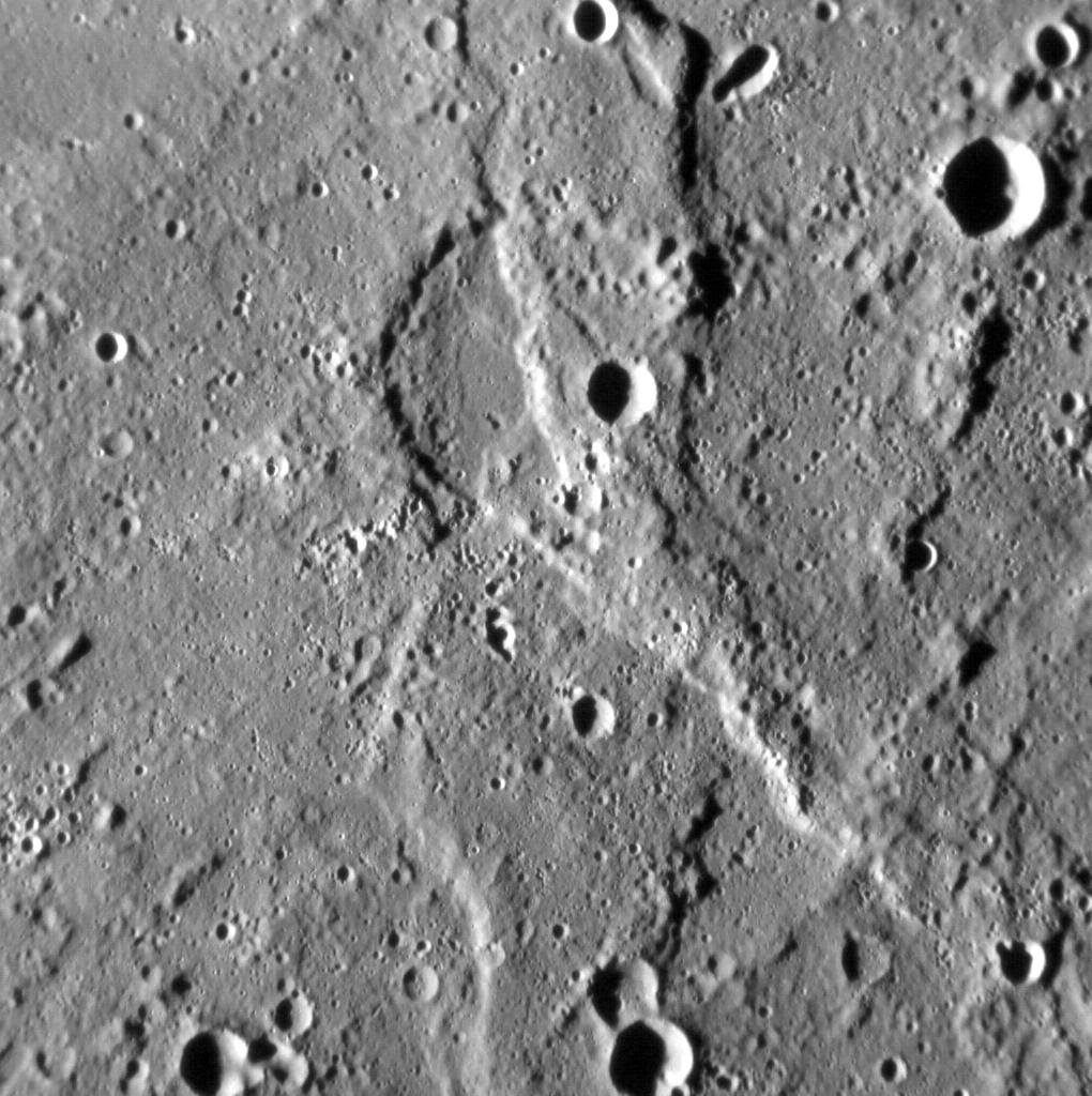
The Rembrandt basin is the second-largest well preserved impact structure on Mercury, and is one of the best examples of a process that has irrevocably shaped the surface of the innermost planet. Yet the planet has been fundamentally shaped by another process -- global contraction -- that has resulted in the formation of lobate scarps and wrinkle ridges across the surface of Mercury.
In this image, we see a good example of where these processes meet. The most prominent landform in the scene is a north-west-trending scarp, its eastern margin illuminated by the Sun. Scarps such as this form when one portion of Mercury's crust thrusts up over another, the result of crustal shortening in response to the planet's volume decreasing as its interior cools. Yet if you look carefully, you might spy an alignment in the texture of the surface here, trending from the bottom-left to the top-right of the image. This alignment is due to radial scouring of the surface around Rembrandt by debris thrown out during the impact that formed the basin.
This image was acquired as a high-resolution targeted observation. Targeted observations are images of a small area on Mercury's surface at resolutions much higher than the 200-meter/pixel morphology base map. It is not possible to cover all of Mercury's surface at this high resolution, but typically several areas of high scientific interest are imaged in this mode each week.
Date acquired: November 5, 2013
Image Mission Elapsed Time (MET): 25999800
Image ID: 5142079
Instrument: Narrow Angle Camera (NAC) of the Mercury Dual Imaging System (MDIS)
Center Latitude: -20.99°
Center Longitude: 100.55° E
Resolution: 115 meters/pixel
Scale: The field of view in this image is about 120 km (75 mi.) across
Incidence Angle: 79.4°
Emission Angle: 12.2°
Phase Angle: 67.2°
North is to the bottom of the image.
Image credit: NASA/Johns Hopkins University Applied Physics Laboratory/Carnegie Institution of Washington

The impact crater at the top center of this image is characterized by a sharp rim and high-reflectance ejecta. Lobes of slumped material are found where the wall meets the floor. The central peak is notable because it contains a pit. A recent survey1 found 27 central pit craters on Mercury. All of these central pit craters are located in plains units, but the mechanism by which the pits form is uncertain.
1 Z. Xiao and G. Komatsu (2013), Impact craters with ejecta flows and central pits on Mercury, Planetary and Space Science, vol. 82-83, pp. 62-78.
This image was acquired as part of MDIS's high-resolution surface morphology base map. The surface morphology base map covers more than 99% of Mercury's surface with an average resolution of 200 meters/pixel. Images acquired for the surface morphology base map typically are obtained at off-vertical Sun angles (i.e., high incidence angles) and have visible shadows so as to reveal clearly the topographic form of geologic features.
Date acquired: July 17, 2011
Image Mission Elapsed Time (MET): 219350124
Image ID: 513704
Instrument: Narrow Angle Camera (NAC) of the Mercury Dual Imaging System (MDIS)
Center Latitude: 19.42°
Center Longitude: 63.27° E
Resolution: 143 meters/pixel
Scale: The impact crater of interest is about 17 km (11 mi.) in diameter
Incidence Angle: 59.8°
Emission Angle: 12.8°
Phase Angle: 47.0°
Image credit: NASA/Johns Hopkins University Applied Physics Laboratory/Carnegie Institution of Washington

The left side of today's image is dominated by an unnamed 75-km-diameter impact crater. The crater has several interesting features. Its western wall is quite broad, with extensive terracing and landslide scarps. The floor of the crater is flat, having been filled by volcanic plains or impact melt. The small central peaks, parts of the floor, and spots along the eastern rim are dotted with high-reflectance hollows. Finally, as outlined in the inset, the ejecta to the north and east of the rim appears to have flowed along the ground, and formed a terminal scarp. A recent paper by Beary Xiao and Goro Komatsu discusses this and other Mercurian craters that have flow-like ejecta, and makes comparisons with similar landforms on the Moon and Mars.
Z. Xiao and G. Komatsu (2013), Impact craters with ejecta flows and central pits on Mercury, Planetary and Space Science, vol. 82-83, pp. 62-78.
This image was acquired as part of MDIS's high-resolution stereo imaging campaign. Images from the stereo imaging campaign are used in combination with the surface morphology base map or the albedo base map to create high-resolution stereo views of Mercury's surface, with an average resolution of 200 meters/pixel. Viewing the surface under the same Sun illumination conditions but from two or more viewing angles enables information about the small-scale topography of Mercury's surface to be obtained.
Date acquired: November 03, 2011
Image Mission Elapsed Time (MET): 228803487
Image ID: 966206
Instrument: Wide Angle Camera (WAC) of the Mercury Dual Imaging System (MDIS)
WAC filter: 7 (748 nanometers)
Center Latitude: 13.45°
Center Longitude: 298.0° E
Resolution: 182 meters/pixel
Scale: The scene is about 190 km (118 mi.) across
Incidence Angle: 68.6°
Emission Angle: 15.5°
Phase Angle: 55.3°
North is up in this image.
Image credit: NASA/Johns Hopkins University Applied Physics Laboratory/Carnegie Institution of Washington

Wolfgang's namesake basin has had a large effect on Mercury. Ejecta from the 241-kilometer-diameter (150 mile) impact basin has left an enormous network of rough terrain, in beautiful contrast to the basin's smooth interior. Mozart basin lies just a hop, skip and a jump away from the planet's largest impact basin, Caloris.
This image was acquired as a high-resolution targeted observation. Targeted observations are images of a small area on Mercury's surface at resolutions much higher than the 200-meter/pixel morphology base map. It is not possible to cover all of Mercury's surface at this high resolution, but typically several areas of high scientific interest are imaged in this mode each week.
Date acquired: October 02, 2013
Image Mission Elapsed Time (MET): 22999301
Image ID: 4929063
Instrument: Narrow Angle Camera (NAC) of the Mercury Dual Imaging System (MDIS)
Center Latitude: 12.52°
Center Longitude: 168.0° E
Resolution: 47 meters/pixel
Scale: The entire image is approximately 95 km (59 mi.) across.
Incidence Angle: 78.9°
Emission Angle: 59.6°
Phase Angle: 138.5°
North is down in this image.
Photo credit: NASA/Johns Hopkins University Applied Physics Laboratory/Carnegie Institution of Washington

First seen by Mariner 10 in 1974, Tansen has not been featured on MESSENGER's gallery until today. It is among Mercury's smaller named craters at just 27 kilometers (~17 mi.) in diameter. The ejecta rays formed by the impact appear prominent in this color mosaic, as does the small, fresh crater ejecta deposit at the very top of the image.
This image was acquired as a targeted high-resolution 11-color image set. Acquiring 11-color targets is a new campaign that began in March 2013 and that utilizes all of the WAC's 11 narrow-band color filters. Because of the large data volume involved, only features of special scientific interest are targeted for imaging in all 11 colors.
Date acquired: September 09, 2013
Image Mission Elapsed Time (MET): 21069217, 21069209, 21069205
Image ID: 4791897, 4791895, 4791894
Instrument: Wide Angle Camera (WAC) of the Mercury Dual Imaging System (MDIS)
WAC filters: 9, 7, 6 (996, 748, 433 nanometers) in red, green, and blue
Center Latitude: 3.84°
Center Longitude: 288.4° E
Resolution: 301 meters/pixel
Scale: Tansen is approximately 27 kilometers (17 mi.) in diameter
Incidence Angle: 31.7°
Emission Angle: 24.5°
Phase Angle: 56.2°
Photo credit: NASA/Johns Hopkins University Applied Physics Laboratory/Carnegie Institution of Washington

The Caloris basin contains a complex mix of impact, tectonic, and volcanic features. At center-right, the elongate depression may be a volcanic vent within the basin. This feature highlights the ambiguity that sometimes arises in discerning whether a depression is due to an impact or a volcanic event, as both can leave elongate depressions. One clue that might point to volcanism is the depression's slightly irregular shape; another is the apparent lack of a rim of impact ejecta that is raised above the baseline level of the surrounding terrain.
This image was acquired as a high-resolution targeted observation. Targeted observations are images of a small area on Mercury's surface at resolutions much higher than the 200-meter/pixel morphology base map. It is not possible to cover all of Mercury's surface at this high resolution, but typically several areas of high scientific interest are imaged in this mode each week.
Date acquired: June 30, 2013
Image Mission Elapsed Time (MET): 14936140
Image ID: 4355811
Instrument: Narrow Angle Camera (NAC) of the Mercury Dual Imaging System (MDIS)
Center Latitude: 24.18°
Center Longitude: 148.1° E
Resolution: 48 meters/pixel
Scale: The proposed vent is 17.9 km (11.1 mi.) across
Incidence Angle: 66.0°
Emission Angle: 50.3°
Phase Angle: 115.4°
Photo credit: NASA/Johns Hopkins University Applied Physics Laboratory/Carnegie Institution of Washington

Fresh and bright, this unnamed, elongated crater appears to have been formed by an impactor that struck the surface at an oblique angle, causing most of the ejecta to be thrown out unevenly around the crater (notice the bright rays above, below, and to the right of the crater). The marginally bright material in the bottom left corner is actually part of a ray from Hokusai, over 1380 km (about 860 mi.) away!
This image was acquired as a high-resolution targeted color observation. Targeted color observations are images of a small area on Mercury's surface at resolutions higher than the 1-kilometer/pixel 8-color base map. During MESSENGER's one-year primary mission, hundreds of targeted color observations were obtained. During MESSENGER's extended mission, high-resolution targeted color observations are more rare, as the 3-color base map covered Mercury's northern hemisphere with the highest-resolution color images that are possible.
Date acquired: August 19, 2011
Image Mission Elapsed Time (MET): 222275999, 222275995, 222275991
Image ID: 652862, 652861, 652860
Instrument: Wide Angle Camera (WAC) of the Mercury Dual Imaging System (MDIS)
WAC filters: 9, 7, 6 (996, 748, 433 nanometers) in red, green, and blue
Center Latitude: 27.84°
Center Longitude: 30.73° E
Resolution: 116 meters/pixel
Scale: The small bright crater measures about 13 km (8 mi.) in long dimension.
Incidence Angle: 31.1°
Emission Angle: 37.2°
Phase Angle: 68.3°
Photo credit: NASA/Johns Hopkins University Applied Physics Laboratory/Carnegie Institution of Washington

Here multiple generations of craters can be seen. On Mercury, billions of years of impact events can be seen where older craters have younger craters within the interior and on the rim and ejecta. When comparing different terrains on Mercury, the number of craters per unit area can be used to estimate the absolute age of the surfaces, as well as to give insight into the relative ages of the terrains.
This image was acquired as part of MDIS's high-resolution 3-color imaging campaign. The map produced from this campaign complements the 8-color base map (at an average resolution of 1 km/pixel) acquired during MESSENGER's primary mission by imaging Mercury's surface in a subset of the color filters at the highest resolution possible. The three narrow-band color filters are centered at wavelengths of 430 nm, 750 nm, and 1000 nm, and image resolutions generally range from 100 to 400 meters/pixel in the northern hemisphere.
Date acquired: May 23, 2013
Image Mission Elapsed Time (MET): 11621959, 11621954, 11621956
Image ID: 4120141, 4120139, 4120140
Instrument: Wide Angle Camera (WAC) of the Mercury Dual Imaging System (MDIS)
WAC filters: 9, 7, 6 (996, 748, 433 nanometers) in red, green, and blue
Center Latitude: 66.03°
Center Longitude: 243.7° E
Resolution: 183 meters/pixel
Scale: The larger crater is 48 km in diameter (29.5 miles).
Incidence Angle: 79.5°
Emission Angle: 0.2°
Phase Angle: 79.7°
Photo credit: NASA/Johns Hopkins University Applied Physics Laboratory/Carnegie Institution of Washington
The crater Matabei, shown here, exhibits a dark ray system projecting from one side of the crater. Rays emanating from only certain sides of the crater can be due to an impactor that came in at a grazing angle, such as seen for the craters Hovnatanian and Qi Baishi. However dark rays like these can also indicate an irregular distribution of dark material below the surface. The dark rays are likely sub-surface material that was excavated and ejected out during the initial impact. It is also interesting to note the extensive hollows, identifiable as the bright regions in the southern half of the crater.
Date acquired: August 30, 2011
Image Mission Elapsed Time (MET): 223185654
Image ID: 695876
Instrument: Narrow Angle Camera (NAC) of the Mercury Dual Imaging System (MDIS)
Center Latitude: -40.07°
Center Longitude: 345.8° E
Resolution: 98 meters/pixel
Scale: Matabei is 24 km. in diameter (15 mi.)
Incidence Angle: 42.4°
Emission Angle: 6.4°
Phase Angle: 46.6°
Photo credit: NASA/Johns Hopkins University Applied Physics Laboratory/Carnegie Institution of Washington


 Posts
Posts


