skip to main |
skip to sidebar

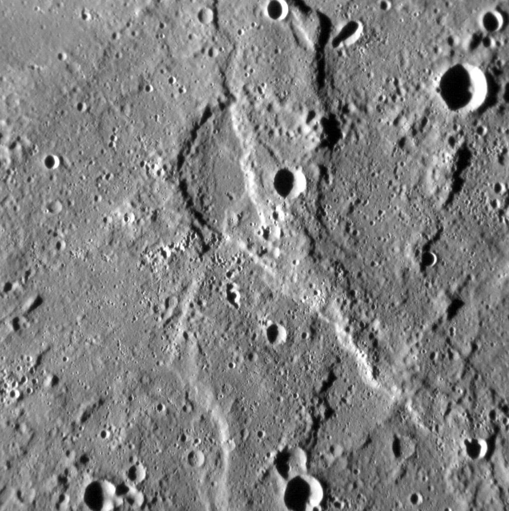
In this image, we see a portion of a wrinkle ridge to the north of Gauguin crater, high in Mercury's northern volcanic plains. Wrinkle ridges are common on Mercury, but when imaged under high resolutions we get a more detailed view of these structures than before. For example, here we can see that the leading edge of the ridge is actually composed of several smaller edges. The contact between the ridge and the surrounding smooth plains is softened toward the bottom right of the image, but near the top-left that contact is sharper. Continued high-resolution imaging of Mercury's wrinkle ridges will allow scientists to more thoroughly describe their various shapes, which in turn will help us understand why the ridges formed in the first place.
This image was acquired as a high-resolution targeted observation. Targeted observations are images of a small area on Mercury's surface at resolutions much higher than the 200-meter/pixel morphology base map. It is not possible to cover all of Mercury's surface at this high resolution, but typically several areas of high scientific interest are imaged in this mode each week.
Date acquired: March 10, 2014
Image Mission Elapsed Time (MET): 36741405
Image ID: 5906004
Instrument: Narrow Angle Camera (NAC) of the Mercury Dual Imaging System (MDIS)
Center Latitude: 69.7°
Center Longitude: 261.6° E
Resolution: 12 meters/pixel
Scale: The field of view in this image is about 6 km (4 mi.) across
Incidence Angle: 75.0°
Emission Angle: 6.9°
Phase Angle: 81.9°
North is to the right in this scene.
Image credit: NASA/Johns Hopkins University Applied Physics Laboratory/Carnegie Institution of Washington

Wrinkle ridges are tectonic landforms observed across all of Mercury's smooth plains deposits, and are often superposed by impact craters. Craters themselves are frequently surrounded by lobate-like ejecta deposits, which at first glance might look like tectonic structures. In this image, a lobate-like feature runs parallel to the northern margin of an unnamed crater 20 km (12 miles) in diameter. Whether this landform is tectonic or impact-related is not yet clear, but with continued high-resolution imaging of other, similarly sized craters, we might be able to tell.
This image was acquired as a high-resolution targeted observation. Targeted observations are images of a small area on Mercury's surface at resolutions much higher than the 200-meter/pixel morphology base map. It is not possible to cover all of Mercury's surface at this high resolution, but typically several areas of high scientific interest are imaged in this mode each week.
Date acquired: March 6, 2014
Image Mission Elapsed Time (MET): 36395675
Image ID: 5881419
Instrument: Narrow Angle Camera (NAC) of the Mercury Dual Imaging System (MDIS)
Center Latitude: 66.3°
Center Longitude: 281.8° E
Resolution: 12 meters/pixel
Scale: The field of view in this image is 14 km (9 mi.) across
Incidence Angle: 70.5°
Emission Angle: 0.3°
Phase Angle: 70.2°
North is to the right in this scene.
Image credit: NASA/Johns Hopkins University Applied Physics Laboratory/Carnegie Institution of Washington

A large (180-km diameter) crater occupies the scene, but it has been almost completely buried by the volcanic plains that make up the northern smooth plains. The rim of the buried crater, especially in the southeast, has helped to localize compressional deformation, leading to a wrinkle-ridge ring. The center is criss-crossed by extensional graben.
These images were acquired as part of MDIS's high-incidence-angle base map. The high-incidence-angle base map complements the surface morphology base map of MESSENGER's primary mission that was acquired under generally more moderate incidence angles. High incidence angles, achieved when the Sun is near the horizon, result in long shadows that accentuate the small-scale topography of geologic features. The high-incidence-angle base map was acquired with an average resolution of 200 meters/pixel.
Date acquired: March 09, 2014
Image Mission Elapsed Time (MET): 36713179, 36713230
Image ID: 5903920, 5903921
Instrument: Wide Angle Camera (WAC) of the Mercury Dual Imaging System (MDIS)
WAC filter: 7 (748 nanometers)
Center Latitude: 64.4°
Center Longitude: 23.8° E
Resolution: 258 meters/pixel
Scale: The buried basin is approximately 180 km (112 miles) across
Incidence Angle: 86.2°
Emission Angle: 51.1°
Phase Angle: 137.3°
Photo credit: NASA/Johns Hopkins University Applied Physics Laboratory/Carnegie Institution of Washington

Scientists have known since Mariner 10 that Mercury has contracted. This contraction is a result of the cooling of Mercury's interior, and is the process responsible for the formation of the planet's wrinkle ridges and lobate scarps. For almost four decades, however, the amount of global contraction measured from spacecraft data has been substantially less than that predicted by models of the thermal evolution of Mercury.
Now, using global photogeological and topographic MESSENGER data of Mercury, members of the MESSENGER team have mapped almost 6,000 ridges and scarps across the planet. Today's image shows the result of this mapping work, with structures color-coded according to one of four classes. (The global photogeological and topographic data used in this study are shown in the bottom left and right, respectively, of the image.) With these results, the MESSENGER team has calculated that Mercury contracted to a much greater extent than had been determined previously from mapping -- by up to seven times more, in fact.
This study was published online in the journal Nature Geoscience on Sunday, March 16, 2014, and is being presented today in the "Mercury" session at the 45th Lunar and Planetary Science Conference, which is being held this week in The Woodlands, Texas. In total, MESSENGER team members are presenting 25 papers at this conference.
Date published online: March 16, 2014
Center Latitude: 0°
Center Longitude: 0°E
Projection: Molleweide
Reference: Byrne et al. (2014) Mercury's global contraction much greater than earlier estimates, Nature Geoscience, doi:10.1038/NGEO2097
Map credit: NASA/Johns Hopkins University Applied Physics Laboratory/Carnegie Institution of Washington
The Rembrandt basin is the second-largest well preserved impact structure on Mercury, and is one of the best examples of a process that has irrevocably shaped the surface of the innermost planet. Yet the planet has been fundamentally shaped by another process -- global contraction -- that has resulted in the formation of lobate scarps and wrinkle ridges across the surface of Mercury.
In this image, we see a good example of where these processes meet. The most prominent landform in the scene is a north-west-trending scarp, its eastern margin illuminated by the Sun. Scarps such as this form when one portion of Mercury's crust thrusts up over another, the result of crustal shortening in response to the planet's volume decreasing as its interior cools. Yet if you look carefully, you might spy an alignment in the texture of the surface here, trending from the bottom-left to the top-right of the image. This alignment is due to radial scouring of the surface around Rembrandt by debris thrown out during the impact that formed the basin.
This image was acquired as a high-resolution targeted observation. Targeted observations are images of a small area on Mercury's surface at resolutions much higher than the 200-meter/pixel morphology base map. It is not possible to cover all of Mercury's surface at this high resolution, but typically several areas of high scientific interest are imaged in this mode each week.
Date acquired: November 5, 2013
Image Mission Elapsed Time (MET): 25999800
Image ID: 5142079
Instrument: Narrow Angle Camera (NAC) of the Mercury Dual Imaging System (MDIS)
Center Latitude: -20.99°
Center Longitude: 100.55° E
Resolution: 115 meters/pixel
Scale: The field of view in this image is about 120 km (75 mi.) across
Incidence Angle: 79.4°
Emission Angle: 12.2°
Phase Angle: 67.2°
North is to the bottom of the image.
Image credit: NASA/Johns Hopkins University Applied Physics Laboratory/Carnegie Institution of Washington

Mercury's surface has been extensively modified by tectonic activity. Giant thrust faults are thought to be the result of global cooling and contraction of the planet, and Mercury's smooth plains in particular are folded and wrinkled. With the Sun very low in the sky, the complexity of tectonic features in the northern volcanic plains is especially apparent. The wrinkle-ridge ring (also known as a "ghost crater") on the eastern edge of the scene was also captured here (see PIA15636) at more moderate illumination angles.
This image was acquired as part of MDIS's high-incidence-angle base map. The high-incidence-angle base map complements the surface morphology base map of MESSENGER's primary mission that was acquired under generally more moderate incidence angles. High incidence angles, achieved when the Sun is near the horizon, result in long shadows that accentuate the small-scale topography of geologic features. The high-incidence-angle base map was acquired with an average resolution of 200 meters/pixel.
Date acquired: November 12, 2013
Image Mission Elapsed Time (MET): 26543953
Image ID: 5181050
Instrument: Wide Angle Camera (WAC) of the Mercury Dual Imaging System (MDIS)
WAC filter: 7 (748 nanometers)
Center Latitude: 80.04°
Center Longitude: 86.24° E
Resolution: 230 meters/pixel
Scale: Scene is 125 km (78 miles) from top to bottom
Incidence Angle: 90.7°
Emission Angle: 49.8°
Phase Angle: 140.6°
Photo credit: NASA/Johns Hopkins University Applied Physics Laboratory/Carnegie Institution of Washington

Simple craters adorn Mercury's surface. This unnamed example lies in the northern volcanic plains, and likely post-dates most of the volcanism in the region. Its raised rim is still largely preserved, suggesting that it is relatively young -- by Mercury's standards: it's probably still many millions of years old! Its interior is slightly raised, the result of deformation by a small wrinkle ridge located just to its east.
This image was acquired as a high-resolution targeted observation. Targeted observations are images of a small area on Mercury's surface at resolutions much higher than the 200-meter/pixel morphology base map. It is not possible to cover all of Mercury's surface at this high resolution, but typically several areas of high scientific interest are imaged in this mode each week.
Date acquired: September 02, 2013
Image Mission Elapsed Time (MET): 20407784
Image ID: 4744802
Instrument: Narrow Angle Camera (NAC) of the Mercury Dual Imaging System (MDIS)
Center Latitude: 63.4°
Center Longitude: 336.0° E
Resolution: 23.9 meters/pixel
Scale: This crater is 9.4 km (5.8 mi.) in diameter
Incidence Angle: 63.51°
Emission Angle: 9.49°
Phase Angle: 54.02°
North is to the right of the image.
Photo credit: NASA/Johns Hopkins University Applied Physics Laboratory/Carnegie Institution of Washington
This view of a location within Mercury's northern volcanic plains includes a set of wrinkle ridges that form a "V" shape.
This image was acquired as part of MDIS's high-resolution surface morphology base map. The surface morphology base map covers more than 99% of Mercury's surface with an average resolution of 200 meters/pixel. Images acquired for the surface morphology base map typically are obtained at off-vertical Sun angles (i.e., high incidence angles) and have visible shadows so as to reveal clearly the topographic form of geologic features.
Date acquired: October 14, 2011
Image Mission Elapsed Time (MET): 227092494
Image ID: 884412
Instrument: Wide Angle Camera (WAC) of the Mercury Dual Imaging System (MDIS)
WAC filter: 7 (748 nanometers)
Center Latitude: 79.09°
Center Longitude: 352.7° E
Resolution: 140 meters/pixel
Scale: The "V" is about 59 km (37 mi.) long
Incidence Angle: 84.1°
Emission Angle: 28.2°
Phase Angle: 112.3°
Photo credit: NASA/Johns Hopkins University Applied Physics Laboratory/Carnegie Institution of Washington
This view shows the edge of the Goethe Basin. The margins of the basin interior are marked by wrinkle ridges. Part of one such ridge is shown in this image. The scene also includes small secondary crater chains on the smooth plains that fill the basin, and the hummocky terrain outside of the basin.
Date acquired: February 10, 2013
Image Mission Elapsed Time (MET): 2778942, 2778934, 2778938
Image ID: 3491366, 3491364, 3491365
Instrument: Wide Angle Camera (WAC) of the Mercury Dual Imaging System (MDIS)
WAC filters: 9, 7, 6 (996, 748, 433 nanometers) in red, green, and blue
Center Latitude: 82.92°
Center Longitude: 286.5° E
Resolution: 86 meters/pixel
Scale: The small crater in the center of the image is 2.7 km (1.7 miles) in diameter.
Incidence Angle: 88.0°
Emission Angle: 17.5°
Phase Angle: 87.8°
Photo credit: NASA/Johns Hopkins University Applied Physics Laboratory/Carnegie Institution of Washington
The northern plains on Mercury have lower elevation than surrounding regions. This view of the northern plains includes many wrinkle ridges, a result of tectonic deformation. The ridges outline the rim of a ghost crater, formed when lava covered the crater and differential sagging took place over the rim. The ghost rim is joined by four other prominent ridges.
Date acquired: February 13, 2013
Image Mission Elapsed Time (MET): 3038383, 3038375, 3038379
Image ID: 3509798, 3509796, 3509797
Instrument: Wide Angle Camera (WAC) of the Mercury Dual Imaging System (MDIS)
WAC filters: 9, 7, 6 (996, 748, 433 nanometers) in red, green, and blue
Center Latitude: 69.58°
Center Longitude: 284.1° E
Resolution: 91 meters/pixel
Scale: The ghost crater is 21 km (13 miles) in diameter.
Incidence Angle: 84.9°
Emission Angle: 0.1°
Phase Angle: 85.0°
Photo credit: NASA/Johns Hopkins University Applied Physics Laboratory/Carnegie Institution of Washington

The northern plains of Mercury are home to many volcanically flooded craters such as Monteverdi, which occupies part of the lower edge of this image. The plains have abundant wrinkle ridges and fresh craters.
This image was acquired as part of MDIS's minimum-phase-angle color campaign. Near the north polar region, the incidence angle (measured from the vertical) is always fairly high because the Sun is low on the horizon. The minimum-phase-angle color campaign acquires images under conditions that minimize the shadows in an image by viewing the surface as nearly as possible from the same direction as the Sun's illumination, which minimizes the phase angle. Images are acquired through five of the WAC's narrow-band color filters, for regions north of 60° N, at an average resolution of 500 meters/pixel. The minimum-phase-angle color campaign began in March 2013.
Date acquired: April 18, 2013
Image Mission Elapsed Time (MET): 8598032, 8598023, 8598029
Image ID: 3905074, 3905071, 3905073
Instrument: Wide Angle Camera (WAC) of the Mercury Dual Imaging System (MDIS)
WAC filters: 9, 7, 6 (996, 748, 433 nanometers) in red, green, and blue
Center Latitude: 66.83°
Center Longitude: 276.7° E
Resolution: 312 meters/pixel
Scale: The image is about 240 km across (149 miles).
Incidence Angle: 78.3°
Emission Angle: 50.3°
Phase Angle: 28.0°
Photo credit: NASA/Johns Hopkins University Applied Physics Laboratory/Carnegie Institution of Washington
This small unnamed crater occurs near a wrinkle ridge in Goethe Basin. Since this image was taken near the north pole of Mercury, the shadows are more dramatic than in the equatorial region.
Date acquired: February 09, 2013
Image Mission Elapsed Time (MET): 2721322, 2721314, 2721318
Image ID: 3487267, 3487265, 3487266
Instrument: Wide Angle Camera (WAC) of the Mercury Dual Imaging System (MDIS)
WAC filters: 9, 7, 6 (996, 748, 433 nanometers) in red, green, and blue
Center Latitude: 83.35°
Center Longitude: 291.6° E
Resolution: 86 meters/pixel
Scale: The larger crater in this image is 9.5 km in diameter (6 miles).
Incidence Angle: 87.6°
Emission Angle: 18.9°
Phase Angle: 87.5°
Photo credit: NASA/Johns Hopkins University Applied Physics Laboratory/Carnegie Institution of Washington

You may have noticed that one of the details we give for each image is the Mission Elapsed Time, or MET, of when it was acquired. MET is the time, in seconds, since the MESSENGER mission began in 2004. As a testament to how long MESSENGER has been in space (over eight years!), the number of seconds has added up to over 250 million, and has come close to reaching the limit of how high the spacecraft clock can count. Thus in January, the MESSENGER team reset the clock, starting over at a time of 1,000 seconds. Why 1,000 seconds rather than zero? The MET clock was originally set to start counting 1,000 seconds before launch, so that launch was actually at an MET of 1,000 rather than zero; the clock reset follows that precedent.
Today's image was acquired at an "MET" of 129,781 seconds, or a day and a half after the count started over. This image shows an interesting crater in the Caloris basin. Craters of irregular shape are often thought to be formed from processes other than impact events, but this crater could be a cluster of several smaller craters or its shape could have been modified by the wrinkle ridge that crosses the scene from northwest to southeast. North is up in this image.
Date acquired: January 10, 2013
Image Mission Elapsed Time (MET): 129781
Image ID: 3302953
Instrument: Narrow Angle Camera (NAC) of the Mercury Dual Imaging System (MDIS)
Center Latitude: 28.08°
Center Longitude: 144.6° E
Resolution: 28 meters/pixel
Scale: This scene is approximately 28 km (17 mi.) across
Incidence Angle: 77.1°
Emission Angle: 0.7°
Phase Angle: 76.4°
Photo credit: NASA/Johns Hopkins University Applied Physics Laboratory/Carnegie Institution of Washington

This image is a portion of the MDIS global mosaic basemap that was acquired during MESSENGER's first year in orbit. The scene shows a region of smooth, volcanic plains that have been heavily modified by tectonic structures termed "wrinkle ridges." Occurring on the Moon and Mars as well as on Mercury, wrinkle ridges are low, sinuous features that form when lavas cool and subside, causing the crust to contract horizontally. These landforms are often concentrated around buried crater rims, forming circular wrinkle ridges like those in the center right of the image.
While the innermost planet hosts thousands of wrinkle ridges, they are largely confined to its smooth plains, and are morphologically different to the larger, longer faults that comprise Mercury's fold-and-thrust belts. By studying how the different types of tectonic features are distributed across Mercury, MESSENGER scientists can begin to document in detail how the planet has deformed through time.
Date Created: February 10, 2012
Instrument: Mercury Dual Imaging System (MDIS)
Latitude Range: 49.6° N to 60.9° N
Longitude Range: 16.5° E to 48.5° E
Resolution: 400 meters/pixel
Scale: Hokusai, the large, fresh impact crater at top left, is 90 km (56 mi.) in diameter.
Projection: Azimuthal equidistant
Photo credit: NASA/Johns Hopkins University Applied Physics Laboratory/Carnegie Institution of Washington

The crater with the central peaks in the northeast portion of this image is located on the eastern rim of a large impact basin. Extending westward from this crater is a wrinkle ridge that may have formed due to contraction as lava that flooded the basin cooled. Scientists studying craters and large impact basins on Mercury learn more and more of the innermost planet's "secrets" as new imagery and data from MESSENGER become available.
This image was acquired as part of MDIS's high-resolution surface morphology base map. The surface morphology base map will cover more than 90% of Mercury's surface with an average resolution of 250 meters/pixel (0.16 miles/pixel or 820 feet/pixel). Images acquired for the surface morphology base map typically have off-vertical Sun angles (i.e., high incidence angles) and visible shadows so as to reveal clearly the topographic form of geologic features.
Date acquired: July 13, 2011
Image Mission Elapsed Time (MET): 219011692
Image ID: 497387
Instrument: Wide Angle Camera (WAC) of the Mercury Dual Imaging System (MDIS)
WAC filter: 7 (748 nanometers)
Center Latitude: 69.75°
Center Longitude: 110.8° E
Resolution: 248 meters/pixel
Scale: Image diagonal is ~180 km (112 mi)
Incidence Angle: 71.3°
Emission Angle: 0.2°
Phase Angle: 71.4°
Photo credit: NASA/Johns Hopkins University Applied Physics Laboratory/Carnegie Institution of Washington


 Posts


