Showing posts with label Scarps. Show all posts

Saturday, September 20, 2014

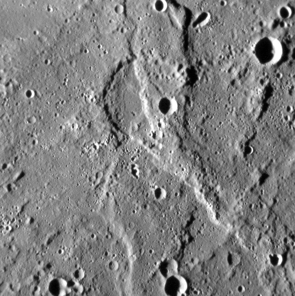
Secondary Impact Craters on a Lobate Scarp


In and of itself, this image of a portion of a north-south-trending lobate scarp, situated midway between Firdousi crater and Caravaggio basin, is not particularly noteworthy. Look a little closer, however, and this little part of Mercury's surface takes on a strange, pitted appearance. A number of shallow, teardrop-shaped depressions occur throughout the image, aligned from the top-left to the bottom-right. This distinctive surface texture is likely caused by debris thrown out by nearby impacts (there is a crater 11 km, or 7 miles, in diameter to the southeast that might be responsible, for example). If so, then these small depressions are effectively secondary impact craters-but not quite like those we're used to seeing. The difference between these depressions and what we normally think of as secondary craters is likely due to size: as MESSENGER gets closer to the surface of Mercury, we are seeing more and more fascinating features at ever greater resolutions. What else will we see before MESSENGER's adventure ends?

This image was acquired as a high-resolution targeted observation. Targeted observations are images of a small area on Mercury's surface at resolutions much higher than the 200-meter/pixel morphology base map. It is not possible to cover all of Mercury's surface at this high resolution, but typically several areas of high scientific interest are imaged in this mode each week.

Date acquired: July 31, 2014
Image Mission Elapsed Time (MET): 49172453
Image ID: 6788651
Instrument: Narrow Angle Camera (NAC) of the Mercury Dual Imaging System (MDIS)
Center Latitude: 1.2°
Center Longitude: 77.7° E
Resolution: 23 meters/pixel
Scale: The left-to-right field of view in this image is 21 km (13 miles) across
Incidence Angle: 77.1°
Emission Angle: 1.9°
Phase Angle: 78.9°
Orientation: North is up in this image.

Image credit: NASA/Johns Hopkins University Applied Physics Laboratory/Carnegie Institution of Washington

Thursday, September 18, 2014

Lobate Scarps in Thakur Crater


We've seen Thakur before - both in full color and as part of a larger view of this region of Mercury. This time, in an oblique view of its southern portion, we can see how two prominent lobate scarps deform the crater. These scarps form when one block of crust thrusts up and over another, and are thought to have formed due to a reduction in Mercury's surface area as its interior cooled and contracted. The face of a scarp indicates the direction these blocks have moved so, as we see it here, Tharkur has been squeezed from the top-right and from the bottom-left.

This image was acquired as a high-resolution targeted observation. Targeted observations are images of a small area on Mercury's surface at resolutions much higher than the 200-meter/pixel morphology base map. It is not possible to cover all of Mercury's surface at this high resolution, but typically several areas of high scientific interest are imaged in this mode each week.

Date acquired: July 21, 2014
Image Mission Elapsed Time (MET): 48249572
Image ID: 6723137
Instrument: Narrow Angle Camera (NAC) of the Mercury Dual Imaging System (MDIS)
Center Latitude: 3.8° S
Center Longitude: 295.8° E
Resolution: 75 meters/pixel
Scale: The left-to-right field of view in this image is approximately 80 km (50 miles) across
Incidence Angle: 65.2°
Emission Angle: 56.9°
Phase Angle: 28.2°
Orientation: North is to the lower right of the image.

Image credit: NASA/Johns Hopkins University Applied Physics Laboratory/Carnegie Institution of Washington

Tuesday, June 10, 2014

Impact Crater Above a Scarp


Today's image features several of Mercury's simple craters. The morphology of simple craters is characterized by the crater's distinct bowl shape and crisp rim. The largest simple crater in this view is positioned just above a scarp. Scarps are common topographic features on Mercury that form as one block of the planet's crust is thrusted forward over another block.

This image was acquired as a high-resolution targeted observation. Targeted observations are images of a small area on Mercury's surface at resolutions much higher than the 200-meter/pixel morphology base map. It is not possible to cover all of Mercury's surface at this high resolution, but typically several areas of high scientific interest are imaged in this mode each week.

Date acquired: June 24, 2013
Image Mission Elapsed Time (MET): 14415278
Image ID: 4318782
Instrument: Narrow Angle Camera (NAC) of the Mercury Dual Imaging System (MDIS)
Center Latitude: 19.56°
Center Longitude: 45.40° E
Resolution: 35 meters/pixel
Scale: The crater in the upper center of this image has a diameter of approximately 6.6 km (4.1 miles)
Incidence Angle: 61.4°
Emission Angle: 31.1°
Phase Angle: 92.2°

Image credit: NASA/Johns Hopkins University Applied Physics Laboratory/Carnegie Institution of Washington

Wednesday, April 30, 2014

Scarp Near the Western Edge of Rembrandt Basin


Today's image is located on the western edge of the Rembrandt basin. A scarp cuts right through a pair of older impact craters, leaving them deformed. This image is an anaglyph, which creates a 3D effect when viewed through a pair of red-cyan glass. If you've found a pair of glasses, check out these other 3D views created with MESSENGER images.

This image was acquired as a targeted set of stereo images. Targeted stereo observations are acquired at resolutions much higher than that of the 200-meter/pixel stereo base map. These targets acquired with the NAC enable the detailed topography of Mercury's surface to be determined for a local area of interest.

Date acquired: August 13, 2013
Image Mission Elapsed Time (MET): 18733660, 18734492
Image ID: 4625953, 4625956
Instrument: Narrow Angle Camera (NAC) of the Mercury Dual Imaging System (MDIS)
Center Latitude: -37.6°
Center Longitude: 79.15° E
Resolution: 100 meters/pixel
Scale: This image is roughly 90 kilometers across (56 miles)
Incidence Angle: 81.0°, 81.0°
Emission Angle: 0.3°, 19.9°
Phase Angle: 81.2°, 81.9°
Orientation: North is to the right to enhance the 3D effect.

Image credit: NASA/Johns Hopkins University Applied Physics Laboratory/Carnegie Institution of Washington

Tuesday, April 8, 2014

Kuniyoshi Crater and Discovery Rupes


The name Kuniyoshi was recently adopted by the International Astronomical Union for the 26.5 km diameter crater near the center of today's image. Utagawa Kuniyoshi was a Japanese painter and printmaker (1798-1861). The subjects of his artwork included landscapes, Kabuki scenes, cats, samurai heroes, and the mythical and supernatural. Kuniyoshi crater is morphologically fresh, with a sharp rim, steep central peak, and impact melt ponds on the floor and near-rim ejecta. To the west of Kuniyoshi is a famous Mercurian lobate scarp, Discovery Rupes.

This image was acquired as part of MDIS's high-resolution surface morphology base map. The surface morphology base map covers more than 99% of Mercury's surface with an average resolution of 200 meters/pixel. Images acquired for the surface morphology base map typically are obtained at off-vertical Sun angles (i.e., high incidence angles) and have visible shadows so as to reveal clearly the topographic form of geologic features.

Date acquired: February 25, 2012
Image Mission Elapsed Time (MET): 238701357
Image ID: 1441474
Instrument: Narrow Angle Camera (NAC) of the Mercury Dual Imaging System (MDIS)
Center Latitude: -57.65°
Center Longitude: 321.8° E
Resolution: 173 meters/pixel
Scale: The edges of the image are about 170 km (105 mi.) long.
Incidence Angle: 65.0°
Emission Angle: 0.7°
Phase Angle: 65.2°

Photo credit: NASA/Johns Hopkins University Applied Physics Laboratory/Carnegie Institution of Washington

Friday, April 4, 2014

Boëthius Crater


The crater shown here, Boëthius, is 115 km (71 miles) in diameter. We have seen Boëthius before, when it was imaged by MESSENGER during its second flyby. Named for the early sixth-century Roman philosopher, Boethius has been filled with smooth plains that may be volcanic in origin. After that infilling, compressional stresses that are pervasive across the entire planet's surface resulted in the formation of the prominent lobate scarp that runs from top to bottom in the image. Boethius is yet another example of the Law of Superposition, which helps scientists to determine the sequence of events at any given location on Mercury.

This image was acquired as a high-resolution targeted observation. Targeted observations are images of a small area on Mercury's surface at resolutions much higher than the 200-meter/pixel morphology base map. It is not possible to cover all of Mercury's surface at this high resolution, but typically several areas of high scientific interest are imaged in this mode each week.

Date acquired: February 1, 2014
Image Mission Elapsed Time (MET): 33546022
Image ID: 5678647
Instrument: Narrow Angle Camera (NAC) of the Mercury Dual Imaging System (MDIS)
Center Latitude: 0.91° S
Center Longitude: 286.88° E
Resolution: 76 meters/pixel
Scale: The scene is 75 km (47 mi.) across
Incidence Angle: 72.8°
Emission Angle: 6.2°
Phase Angle: 66.6°
North is to the bottom in this image

Photo credit: NASA/Johns Hopkins University Applied Physics Laboratory/Carnegie Institution of Washington

Thursday, March 20, 2014

Geological Structure Map of Mercury


Scientists have known since Mariner 10 that Mercury has contracted. This contraction is a result of the cooling of Mercury's interior, and is the process responsible for the formation of the planet's wrinkle ridges and lobate scarps. For almost four decades, however, the amount of global contraction measured from spacecraft data has been substantially less than that predicted by models of the thermal evolution of Mercury.

Now, using global photogeological and topographic MESSENGER data of Mercury, members of the MESSENGER team have mapped almost 6,000 ridges and scarps across the planet. Today's image shows the result of this mapping work, with structures color-coded according to one of four classes. (The global photogeological and topographic data used in this study are shown in the bottom left and right, respectively, of the image.) With these results, the MESSENGER team has calculated that Mercury contracted to a much greater extent than had been determined previously from mapping -- by up to seven times more, in fact.

This study was published online in the journal Nature Geoscience on Sunday, March 16, 2014, and is being presented today in the "Mercury" session at the 45th Lunar and Planetary Science Conference, which is being held this week in The Woodlands, Texas. In total, MESSENGER team members are presenting 25 papers at this conference.

Date published online: March 16, 2014
Center Latitude:
Center Longitude: 0°E
Projection: Molleweide
Reference: Byrne et al. (2014) Mercury's global contraction much greater than earlier estimates, Nature Geoscience, doi:10.1038/NGEO2097

Map credit: NASA/Johns Hopkins University Applied Physics Laboratory/Carnegie Institution of Washington

Tuesday, March 18, 2014

Fault Scarp


New images obtained during low-altitude opportunities when the MESSENGER spacecraft is closest to the surface have revealed a small lobate scarp, identified here with white arrows. Cooling of Mercury's interior over billions of years has caused the planet to contract, forming a network of large landforms called lobate scarps, many over a kilometer high and hundreds of kilometers long. One of the goals for MESSENGER's current extended mission is to determine if there is evidence of young fault scarps that indicate recent contraction of Mercury due to interior cooling and continued solidification of the core. This scarp is only 2 km long, the shortest fault scarp yet found on Mercury. Landforms of this scale must be young, because small features will not survive for billions of years under constant meteoroid bombardment. Lobate scarps of the same scale found on the Moon are thought to be no more than 800 million years old and could be less than 50 million years old. Thus, this small scarp and others likely to be discovered in low-altitude images could provide evidence of very recent contraction of Mercury.

This image was acquired as a high-resolution targeted observation. Targeted observations are images of a small area on Mercury's surface at resolutions much better than that of the 200-meter/pixel morphology base map. It is not possible to cover all of Mercury's surface at this high resolution, but typically several areas of high scientific interest are imaged in this mode each week.

Date acquired: February 09, 2014
Image Mission Elapsed Time (MET): 34263837, 34263839
Image ID: 5729947, 5729948
Instrument: Narrow Angle Camera (NAC) of the Mercury Dual Imaging System (MDIS)
Center Latitude: 65.8°
Center Longitude: 64.8° E
Resolution: 17 meters/pixel
Scale: 2-kilometer (1.2-mile) scale bar shown on the image
Incidence Angle: 79.7°
Emission Angle: 33.5°
Phase Angle: 113.3°

Photo credit: NASA/Johns Hopkins University Applied Physics Laboratory/Carnegie Institution of Washington

Thursday, January 16, 2014

Terror Rupes


We have seen limb images of Mercury many times before, and they never fail to showcase the geological diversity (and splendor!) of the innermost planet. This time, something fills the scene with terror -- Terror Rupes, to be precise, the long, cliff-like landform visible at the center of the scene. Terror Rupes is one of Mercury's most prominent lobate scarps, and was named for HMS Terror, an eighteenth-century warship that later participated in scientific polar explorations. (For an explanation for how lobate scarps likely form, see this previous featured image.)

This image was acquired as part of MDIS's limb imaging campaign. Once per week, MDIS captures images of Mercury's limb, with an emphasis on imaging the southern hemisphere limb. These limb images provide information about Mercury's shape and complement measurements of topography made by the Mercury Laser Altimeter (MLA) of Mercury's northern hemisphere.

Date acquired: February 04, 2012
Image Mission Elapsed Time (MET): 236853865
Image ID: 1353252
Instrument: Wide Angle Camera (WAC) of the Mercury Dual Imaging System (MDIS)
WAC filter: 7 (748 nanometers)
Center Latitude: -69.3°
Center Longitude: 96.0° E
Resolution: 2.7 kilometers/pixel
Incidence Angle: 80.3°
Emission Angle: 50.9°
Phase Angle: 114.5°

Image credit: NASA/Johns Hopkins University Applied Physics Laboratory/Carnegie Institution of Washington

Tuesday, January 14, 2014

Lobate Scarp in Rembrandt Basin


The Rembrandt basin is the second-largest well preserved impact structure on Mercury, and is one of the best examples of a process that has irrevocably shaped the surface of the innermost planet. Yet the planet has been fundamentally shaped by another process -- global contraction -- that has resulted in the formation of lobate scarps and wrinkle ridges across the surface of Mercury.

In this image, we see a good example of where these processes meet. The most prominent landform in the scene is a north-west-trending scarp, its eastern margin illuminated by the Sun. Scarps such as this form when one portion of Mercury's crust thrusts up over another, the result of crustal shortening in response to the planet's volume decreasing as its interior cools. Yet if you look carefully, you might spy an alignment in the texture of the surface here, trending from the bottom-left to the top-right of the image. This alignment is due to radial scouring of the surface around Rembrandt by debris thrown out during the impact that formed the basin.

This image was acquired as a high-resolution targeted observation. Targeted observations are images of a small area on Mercury's surface at resolutions much higher than the 200-meter/pixel morphology base map. It is not possible to cover all of Mercury's surface at this high resolution, but typically several areas of high scientific interest are imaged in this mode each week.

Date acquired: November 5, 2013
Image Mission Elapsed Time (MET): 25999800
Image ID: 5142079
Instrument: Narrow Angle Camera (NAC) of the Mercury Dual Imaging System (MDIS)
Center Latitude: -20.99°
Center Longitude: 100.55° E
Resolution: 115 meters/pixel
Scale: The field of view in this image is about 120 km (75 mi.) across
Incidence Angle: 79.4°
Emission Angle: 12.2°
Phase Angle: 67.2°
North is to the bottom of the image.

Image credit: NASA/Johns Hopkins University Applied Physics Laboratory/Carnegie Institution of Washington
Tuesday, January 7, 2014

Flow-Like Ejecta From an Unnamed Crater


The left side of today's image is dominated by an unnamed 75-km-diameter impact crater. The crater has several interesting features. Its western wall is quite broad, with extensive terracing and landslide scarps. The floor of the crater is flat, having been filled by volcanic plains or impact melt. The small central peaks, parts of the floor, and spots along the eastern rim are dotted with high-reflectance hollows. Finally, as outlined in the inset, the ejecta to the north and east of the rim appears to have flowed along the ground, and formed a terminal scarp. A recent paper by Beary Xiao and Goro Komatsu discusses this and other Mercurian craters that have flow-like ejecta, and makes comparisons with similar landforms on the Moon and Mars.

Z. Xiao and G. Komatsu (2013), Impact craters with ejecta flows and central pits on Mercury, Planetary and Space Science, vol. 82-83, pp. 62-78.

This image was acquired as part of MDIS's high-resolution stereo imaging campaign. Images from the stereo imaging campaign are used in combination with the surface morphology base map or the albedo base map to create high-resolution stereo views of Mercury's surface, with an average resolution of 200 meters/pixel. Viewing the surface under the same Sun illumination conditions but from two or more viewing angles enables information about the small-scale topography of Mercury's surface to be obtained.

Date acquired: November 03, 2011
Image Mission Elapsed Time (MET): 228803487
Image ID: 966206
Instrument: Wide Angle Camera (WAC) of the Mercury Dual Imaging System (MDIS)
WAC filter: 7 (748 nanometers)
Center Latitude: 13.45°
Center Longitude: 298.0° E
Resolution: 182 meters/pixel
Scale: The scene is about 190 km (118 mi.) across
Incidence Angle: 68.6°
Emission Angle: 15.5°
Phase Angle: 55.3°
North is up in this image.

Image credit: NASA/Johns Hopkins University Applied Physics Laboratory/Carnegie Institution of Washington

Friday, December 6, 2013

Unnamed Craters


In the center of this image is a high-reflectance area that seems to be confined to a region of lower elevation that is bounded by linear scarp (cliff) segments. Such diffuse bright areas are sometimes related to the deposition of small secondary craters and ray segments by a relatively recent impact crater, but looking at regional images (for example, using QuickMap), there are no rayed craters in the immediate vicinity (though Han Kan might be a candidate). Therefore, a compositional difference may account for the difference in the albedo (brightness) of the material in the low-lying area. Are the scarps tectonic in nature (the result of vertical movement along faults), or were they formed by secondary crater chains? Also of interest in the scene are hollows on the central peak of the crater at the upper left, and the smooth impact melt on the floor of the terrace-walled crater just below center. Scientists will be at work for many years to solve the puzzle of Mercury's complicated geological history!

This image was acquired as part of the NAC ride-along imaging campaign. When data volume is available and MDIS is not acquiring images for its other campaigns, high-resolution NAC images are obtained of the surface. These images are designed not to interfere with other instrument observations but take full advantage of periods during the mission when extra data volume is available.

Date acquired: May 19, 2012
Image Mission Elapsed Time (MET): 245904903
Image ID: 1853014
Instrument: Narrow Angle Camera (NAC) of the Mercury Dual Imaging System (MDIS)
Center Latitude: -47.3°
Center Longitude: 177.3° E
Resolution: 179 meters/pixel
Scale: The scene is about 184 km (114 mi.) across
Incidence Angle: 47.7°
Emission Angle: 24.2°
Phase Angle: 71.9°

Photo credit: NASA/Johns Hopkins University Applied Physics Laboratory/Carnegie Institution of Washington

Saturday, November 30, 2013

Lobate Scarp North of Mussorgskij Crater


In contrast to a previous image, not all lobate scarps are large. The example pictured here is much smaller -- both in terms of length and relief -- than Discovery Rupes, but it too has contributed to the shortening of Mercury's crust. This scarp cross-cuts an unnamed, 65-km-diameter crater, which is filled with smooth plains, just north of Mussorgskij crater. Whether this scarp is younger than Discovery Rupes and so has not had as much time to accumulate tectonic deformation, or if instead it did not shorten the crust as much for other reasons, remains as yet unclear.

This image was acquired as a high-resolution targeted observation. Targeted observations are images of a small area on Mercury's surface at resolutions much higher than the 200-meter/pixel morphology base map. It is not possible to cover all of Mercury's surface at this high resolution, but typically several areas of high scientific interest are imaged in this mode each week.

Date acquired: September 11, 2013
Image Mission Elapsed Time (MET): 21213842
Image ID: 4802121
Instrument: Narrow Angle Camera (NAC) of the Mercury Dual Imaging System (MDIS)
Center Latitude: 35.4°
Center Longitude: 262.0° E
Resolution: 24.1 meters/pixel
Scale: The field of view in this image is about 29 km (18 mi.) from left to right
Incidence Angle: 60.59°
Emission Angle: 31.91°
Phase Angle: 28.68°
North is to the bottom of the image.

Photo credit: NASA/Johns Hopkins University Applied Physics Laboratory/Carnegie Institution of Washington

Tuesday, November 26, 2013

Discovery Rupes at Rameau Crater


Although one of Mercury's largest lobate scarps, Discovery Rupes is by no means an unusual type of landform on the innermost planet. In fact, scarps cover the surface, and are interpreted to be the result of crustal shortening as Mercury's interior cooled and contracted. In this dramatic view of Discovery Rupes, taken with the Sun low in the sky, the relief along 400-km-long structure can be clearly seen as it cross-cuts Rameau crater.

This image was acquired as a high-resolution targeted observation. Targeted observations are images of a small area on Mercury's surface at resolutions much higher than the 200-meter/pixel morphology base map. It is not possible to cover all of Mercury's surface at this high resolution, but typically several areas of high scientific interest are imaged in this mode each week.

Date acquired: September 23, 2013
Image Mission Elapsed Time (MET): 22261149
Image ID: 4875898
Instrument: Narrow Angle Camera (NAC) of the Mercury Dual Imaging System (MDIS)
Center Latitude: -55.0°
Center Longitude: 322.2° E
Resolution: 246 meters/pixel
Scale: The field of view in this image is about 260 km (162 mi.) from top to bottom
Incidence Angle: 66.87°
Emission Angle: 39.74°
Phase Angle: 106.61°
North is to the top left of the image.

Photo credit: NASA/Johns Hopkins University Applied Physics Laboratory/Carnegie Institution of Washington

Saturday, October 26, 2013

Southwestern Rim of Caloris Basin


This image shows an area of the southwestern rim of the Caloris impact basin. The small hills in the lower left are part of the rim units, and the smooth surface to the right is part of the smooth plains within the basin. The scene lies right on a color boundary between darker rim material and higher-reflectance plains. Small hollows are found on the top of the hills, and small lobate scarps cross the area. The famous kidney-shaped pyroclastic vent is just to the east (right), out of the scene.

This image was acquired as a high-resolution targeted observation. Targeted observations are images of a small area on Mercury's surface at resolutions much higher than the 200-meter/pixel morphology base map. It is not possible to cover all of Mercury's surface at this high resolution, but typically several areas of high scientific interest are imaged in this mode each week.

Date acquired: July 03, 2013
Image Mission Elapsed Time (MET): 15137794
Image ID: 4370103
Instrument: Narrow Angle Camera (NAC) of the Mercury Dual Imaging System (MDIS)
Center Latitude: 22.04°
Center Longitude: 143.6° E
Resolution: 42 meters/pixel
Scale: The scene is about 57 km (35 mi.) across
Incidence Angle: 68.7°
Emission Angle: 31.8°
Phase Angle: 100.1°
North is up in this image.

Photo credit: NASA/Johns Hopkins University Applied Physics Laboratory/Carnegie Institution of Washington

Monday, October 21, 2013

Lobate Scarp Cutting Through Unnamed Crater


Today's image features an unnamed crater 35 km (~22 mi.) in diameter that is cross-cut by a lobate scarp. Superposition relations such as these provide scientists with strong evidence that the surface of Mercury has been extensively shortened, likely in response to the cooling and contraction of the planet's interior through time. Additionally, the change in shape of a once-circular crater cut by a scarp provides a way to estimate the amount of horizontal shortening across that scarp. Such relations, therefore, offer an import insight into the broader geological development of Mercury!

This image was acquired as a high-resolution targeted observation. Targeted observations are images of a small area on Mercury's surface at resolutions much higher than the 200-meter/pixel morphology base map. It is not possible to cover all of Mercury's surface at this high resolution, but typically several areas of high scientific interest are imaged in this mode each week.

Date acquired: August 13, 2013
Image Mission Elapsed Time (MET): 18677753
Image ID: 4621861
Instrument: Narrow Angle Camera (NAC) of the Mercury Dual Imaging System (MDIS)
Center Latitude: -7.05°
Center Longitude: 70.65° E
Resolution: 63 meters/pixel
Scale: The field of view in this image is approx. 80 km (50 mi.) across
Incidence Angle: 70.4°
Emission Angle: 32.8°
Phase Angle: 103.2°
North is up in this image.

Photo credit: NASA/Johns Hopkins University Applied Physics Laboratory/Carnegie Institution of Washington

Thursday, September 19, 2013

Rembrandt's Rim


The Rembrandt basin, first discovered during MESSENGER's second flyby of Mercury, is the youngest of the large impact basins that formed on Mercury. Here you can see a portion of the rim. The rim scarp runs north-south along the scene, casting a meandering shadow that separates the basin exterior on the left from the interior on the right. The two sides don't look hugely different, likely because during and after the basin-forming event molten rock coated much of this area, later solidifying to form the surface we see today.

This image was acquired as a targeted set of stereo images. Targeted stereo observations are acquired at resolutions much higher than that of the 200-meter/pixel stereo base map. These targets acquired with the NAC enable the detailed topography of Mercury's surface to be determined for a local area of interest.

Date acquired: August 14, 2013
Image Mission Elapsed Time (MET): 18791579
Image ID: 4630071
Instrument: Narrow Angle Camera (NAC) of the Mercury Dual Imaging System (MDIS)
Center Latitude: -33.54°
Center Longitude: 77.82° E
Resolution: 104 meters/pixel
Scale: This scene is approximately 106 km (66 mi.) across
Incidence Angle: 79.3°
Emission Angle: 2.8°
Phase Angle: 76.7°

Photo credit: NASA/Johns Hopkins University Applied Physics Laboratory/Carnegie Institution of Washington

Thursday, September 12, 2013

Alvin Rupes


Lobate scarps are one of the most common types of landform on Mercury, and frequently cross-cut impact craters of all sizes. However, the example in this image, termed Alvin Rupes, is one of only a very small subset of scarps that are accompanied by thin, linear depressions on their upper surfaces. One possibility is that these features are graben -- fault-bounded troughs that form when rock is extended -- like those seen in Caloris basin, for example. If so, then these graben are among the only such structures known to occur outside of volcanically flooded impact basins and craters.

This image was acquired as a high-resolution targeted observation. Targeted observations are images of a small area on Mercury's surface at resolutions much higher than the 200-meter/pixel morphology base map. It is not possible to cover all of Mercury's surface at this high resolution, but typically several areas of high scientific interest are imaged in this mode each week.

Date acquired: July 3, 2013
Image Mission Elapsed Time (MET): 15167012
Image ID: 4372157
Instrument: Narrow Angle Camera (NAC) of the Mercury Dual Imaging System (MDIS)
Center Latitude: 7.8°
Center Longitude: 151.1° E
Resolution: 54 meters/pixel
Scale: The crater in the center of the image is about 12 km (7.5 mi.) across
Incidence Angle: 75.6°
Emission Angle: 12.6°
Phase Angle: 88.2°
North is up in this image.

Photo credit: NASA/Johns Hopkins University Applied Physics Laboratory/Carnegie Institution of Washington

Wednesday, July 31, 2013

Rupes


Today's image features a scarp, or cliff face, which is longer than the 77 km shown in this frame. Scarps form as one block of crust is thrusted forward over another, which can result from the cooling of the planet's interior causing global contraction. On Mercury, scarps are called "rupes," which is Latin for cliff.

This image was acquired as a high-resolution targeted observation. Targeted observations are images of a small area on Mercury's surface at resolutions much higher than the 200-meter/pixel morphology base map. It is not possible to cover all of Mercury's surface at this high resolution, but typically several areas of high scientific interest are imaged in this mode each week.

Date acquired: July 08, 2013
Image Mission Elapsed Time (MET): 15627633
Image ID: 4404792
Instrument: Narrow Angle Camera (NAC) of the Mercury Dual Imaging System (MDIS)
Center Latitude: 20.47°
Center Longitude: 141.0° E
Resolution: 51 meters/pixel
Scale: Image width is about 65 km (40.4 miles)
Incidence Angle: 83.4°
Emission Angle: 38.9°
Phase Angle: 45.4°

Photo credit: NASA/Johns Hopkins University Applied Physics Laboratory/Carnegie Institution of Washington

Wednesday, July 10, 2013

Belgica Rupes


This image highlights the difference between the areas on and below the newly named Belgica Rupes. The arrows show Belgica's location, stretching along most of this image for about 764 km. Notice how some of the smaller, newer craters obscure the scarp line, while the older craters were clearly disrupted by the formation of Belgica Rupes.

The word 'rupes' comes from the latin word for cliff. All rupes on Mercury are named after vehicles of exploration. Belgica was a Belgian ship that explored the south pole of earth in 1898. Belgian Rupes is also very close to the southern pole of Mercury. It's name was approved by the IAU on June 6, 2013 along with 9 other rupes.

Date acquired: August 17, 2011
Image Mission Elapsed Time (MET): 222063126, 222063130, 222063122
Image ID: 642667, 642668, 642666
Instrument: Wide Angle Camera (WAC) of the Mercury Dual Imaging System (MDIS)
WAC filters: 3, 4, 6 (479, 558, 433 nanometers) in red, green, and blue
Center Latitude: -52.80°
Center Longitude: 64.08° E
Resolution: 896 meters/pixel
Scale: Belgica Rupes extends 764 km (475 miles).
Incidence Angle: 63.3°
Emission Angle: 0.4°
Phase Angle: 63.2°

Photo credit: NASA/Johns Hopkins University Applied Physics Laboratory/Carnegie Institution of Washington