Saturday, September 28, 2013

Hokusai Crater


This dramatic image features Hokusai in the foreground, famous for its extensive set of rays, some of which extend for over a thousand kilometers across Mercury's surface. The extensive, bright rays indicate that Hokusai is one of the youngest large craters on Mercury. Check out previously featured images to see high-resolution details of its central peaks, rim and ejecta blanket, and impact melt on its floor.

This image was acquired as part of MDIS's high-incidence-angle base map. The high-incidence-angle base map complements the surface morphology base map of MESSENGER's primary mission that was acquired under generally more moderate incidence angles. High incidence angles, achieved when the Sun is near the horizon, result in long shadows that accentuate the small-scale topography of geologic features. The high-incidence-angle base map was acquired with an average resolution of 200 meters/pixel.

Date acquired: September 17, 2013
Image Mission Elapsed Time (MET): 21704875
Image ID: 4836938
Instrument: Wide Angle Camera (WAC) of the Mercury Dual Imaging System (MDIS)
WAC filter: 7 (748 nanometers)
Center Latitude: 58.2.°
Center Longitude: 14.2.° E
Scale: Hokusai has a diameter of 114 km (71 miles)
Orientation: This image is oriented such that north is roughly to the right.

Photo credit: NASA/Johns Hopkins University Applied Physics Laboratory/Carnegie Institution of Washington

Thursday, September 26, 2013

DeGraft Crater


This color image features de Graft and provides a new higher resolution view of the color variations associated with this intriguing crater. The floor of de Graft is covered with bright hollows, which can be seen in detail in this previously released NAC mosaic. The central peaks of de Graft appear blue in this view, similar to the crater Bartok, likely due to material brought up to the surface from depth during the impact event. Around the rim of de Graft, material that appears brighter orange in this image can be identified, which may be yet another different type of rock that exists below the surface and was excavated during the impact, as seen surrounding Kuiper.

This image was acquired as a high-resolution targeted color observation. Targeted color observations are images of a small area on Mercury's surface at resolutions higher than the 1-kilometer/pixel 8-color base map. During MESSENGER's one-year primary mission, hundreds of targeted color observations were obtained. During MESSENGER's extended mission, high-resolution targeted color observations are more rare, as the 3-color base map covered Mercury's northern hemisphere with the highest-resolution color images that are possible.

Date acquired: July 29, 2013
Image Mission Elapsed Time (MET): 17384119, 17384139, 17384123
Image ID: 4529737, 4529742, 4529738
Instrument: Wide Angle Camera (WAC) of the Mercury Dual Imaging System (MDIS)
WAC filters: 9, 7, 6 (996, 748, 433 nanometers) in red, green, and blue
Center Latitude: 21.61°
Center Longitude: 1.48° E
Resolution: 251 meters/pixel
Scale: de Graft has a diameter of 68 kilometers (42 miles)
Incidence Angle: 22.1°
Emission Angle: 55.8°
Phase Angle: 78.0°

Photo credit: NASA/Johns Hopkins University Applied Physics Laboratory/Carnegie Institution of Washington

Wednesday, September 25, 2013

Anaglyph of Volcanic Vent Near Discovery Rupes


Like yesterday's image, and the one from last week, today's image features the same potential volcanic vent. However, today's image is actually a combination of two additional images that were taken by the spacecraft 255 seconds apart. During that time of just over 4 minutes, the spacecraft had moved enough to provide slightly different viewing angles of the same surface, enabling this 3D representation to be made. Find a pair of red-cyan glasses to view the 3D image, and the image has been rotated such that north is to the left to enhance the 3D effect.

This image was acquired as a targeted set of stereo images. Targeted stereo observations are acquired at resolutions much higher than that of the 200-meter/pixel stereo base map. These targets acquired with the NAC enable the detailed topography of Mercury's surface to be determined for a local area of interest.

Date acquired: July 02, 2013
Image Mission Elapsed Time (MET): 15108910, 15109165
Image ID: 4368031, 4368047
Instrument: Narrow Angle Camera (NAC) of the Mercury Dual Imaging System (MDIS)
Center Latitude: 24.28°
Center Longitude: 148.3° E
Resolution: 44 meters/pixel
Scale: This image is 40 km (25 miles) across
Incidence Angle: 72.2°
Emission Angle: 26.1°, 32.9°
Phase Angle: 98.2°, 96.3°

Photo credit: NASA/Johns Hopkins University Applied Physics Laboratory/Carnegie Institution of Washington

Tuesday, September 24, 2013

Possible Volcanic Vent Near Discovery Rupes


Different lighting conditions can reveal different insights into Mercury's surface. Check out this dramatic example of Discovery rupes. Today's image shows the same proposed volcanic vent that was featured last week, but this image was obtained with the Sun more nearly overhead. With this new view, you can see areas of the surface that were previously hidden in shadows.

This image was acquired as a high-resolution targeted observation. Targeted observations are images of a small area on Mercury's surface at resolutions much higher than the 200-meter/pixel morphology base map. It is not possible to cover all of Mercury's surface at this high resolution, but typically several areas of high scientific interest are imaged in this mode each week.

Date acquired: June 06, 2013
Image Mission Elapsed Time (MET): 12831164
Image ID: 4206165
Instrument: Narrow Angle Camera (NAC) of the Mercury Dual Imaging System (MDIS)
Center Latitude: 24.34°
Center Longitude: 148.3° E
Resolution: 28 meters/pixel
Scale: The diameter of the small crater to the left of the proposed vent is about 5 km (3 miles)
Incidence Angle: 26.7°
Emission Angle: 8.5°
Phase Angle: 35.2°

Photo credit: NASA/Johns Hopkins University Applied Physics Laboratory/Carnegie Institution of Washington

Saturday, September 21, 2013

Volcanic Vents North of Rachmaninoff Crater


This beautiful view of the volcanic vents located to the north of the Rachmaninoff basin gives a new perspective on the area. At center, a vent is located within the bright pyroclastic deposit that is thought to have erupted from the vent. An older vent is also seen toward the bottom right as an irregularly shaped depression, though it has no clear surrounding deposit. The oblique angle of the image allows a view of the eastern walls of these features.

Date acquired: August 23, 2013
Image Mission Elapsed Time (MET): 19543205
Image ID: 4683301
Instrument: Wide Angle Camera (WAC) of the Mercury Dual Imaging System (MDIS)
WAC filter: 7 (748 nanometers)
Center Latitude: 35.77°
Center Longitude: 63.90° E
Scale: The central vent is approximately 36 km (22 mi.) across.

Photo credit: NASA/Johns Hopkins University Applied Physics Laboratory/Carnegie Institution of Washington

Friday, September 20, 2013

Southern Hemisphere Craters


Looking toward the horizon, you get a sense of what it might be like to ride along with MESSENGER, taking in the view. In this look at the limb, the large crater near the center is approximately 110 km (68 miles) across. Because the angle between the Sun and the spacecraft is large (a phase angle of 141.6°), we see only the shadowed walls of most small craters, giving the surface a speckled appearance.

This image was acquired as part of MDIS's limb imaging campaign. Once per week, MDIS captures images of Mercury's limb, with an emphasis on imaging the southern hemisphere limb. These limb images provide information about Mercury's shape and complement measurements of topography made by the Mercury Laser Altimeter (MLA) of Mercury's northern hemisphere.

Date acquired: July 16, 2013
Image Mission Elapsed Time (MET): 16312930
Image ID: 4453973
Instrument: Narrow Angle Camera (NAC) of the Mercury Dual Imaging System (MDIS)
Center Latitude: -49.77°
Center Longitude: 352.9° E
Resolution: 183 meters/pixel
Scale: The bright crater at center is approximately 110 km (68 mi.) in diameter
Incidence Angle: 60.7°
Emission Angle: 80.9°
Phase Angle: 141.6°

Photo credit: NASA/Johns Hopkins University Applied Physics Laboratory/Carnegie Institution of Washington

Thursday, September 19, 2013

Rembrandt's Rim


The Rembrandt basin, first discovered during MESSENGER's second flyby of Mercury, is the youngest of the large impact basins that formed on Mercury. Here you can see a portion of the rim. The rim scarp runs north-south along the scene, casting a meandering shadow that separates the basin exterior on the left from the interior on the right. The two sides don't look hugely different, likely because during and after the basin-forming event molten rock coated much of this area, later solidifying to form the surface we see today.

This image was acquired as a targeted set of stereo images. Targeted stereo observations are acquired at resolutions much higher than that of the 200-meter/pixel stereo base map. These targets acquired with the NAC enable the detailed topography of Mercury's surface to be determined for a local area of interest.

Date acquired: August 14, 2013
Image Mission Elapsed Time (MET): 18791579
Image ID: 4630071
Instrument: Narrow Angle Camera (NAC) of the Mercury Dual Imaging System (MDIS)
Center Latitude: -33.54°
Center Longitude: 77.82° E
Resolution: 104 meters/pixel
Scale: This scene is approximately 106 km (66 mi.) across
Incidence Angle: 79.3°
Emission Angle: 2.8°
Phase Angle: 76.7°

Photo credit: NASA/Johns Hopkins University Applied Physics Laboratory/Carnegie Institution of Washington

Tuesday, September 17, 2013

Possible Volcanic Vent Near Discovery Rupes


The Caloris basin contains a complex mix of impact, tectonic, and volcanic features. At center-right, the elongate depression may be a volcanic vent within the basin. This feature highlights the ambiguity that sometimes arises in discerning whether a depression is due to an impact or a volcanic event, as both can leave elongate depressions. One clue that might point to volcanism is the depression's slightly irregular shape; another is the apparent lack of a rim of impact ejecta that is raised above the baseline level of the surrounding terrain.

This image was acquired as a high-resolution targeted observation. Targeted observations are images of a small area on Mercury's surface at resolutions much higher than the 200-meter/pixel morphology base map. It is not possible to cover all of Mercury's surface at this high resolution, but typically several areas of high scientific interest are imaged in this mode each week.

Date acquired: June 30, 2013
Image Mission Elapsed Time (MET): 14936140
Image ID: 4355811
Instrument: Narrow Angle Camera (NAC) of the Mercury Dual Imaging System (MDIS)
Center Latitude: 24.18°
Center Longitude: 148.1° E
Resolution: 48 meters/pixel
Scale: The proposed vent is 17.9 km (11.1 mi.) across
Incidence Angle: 66.0°
Emission Angle: 50.3°
Phase Angle: 115.4°

Photo credit: NASA/Johns Hopkins University Applied Physics Laboratory/Carnegie Institution of Washington

Thursday, September 12, 2013

Alvin Rupes


Lobate scarps are one of the most common types of landform on Mercury, and frequently cross-cut impact craters of all sizes. However, the example in this image, termed Alvin Rupes, is one of only a very small subset of scarps that are accompanied by thin, linear depressions on their upper surfaces. One possibility is that these features are graben -- fault-bounded troughs that form when rock is extended -- like those seen in Caloris basin, for example. If so, then these graben are among the only such structures known to occur outside of volcanically flooded impact basins and craters.

This image was acquired as a high-resolution targeted observation. Targeted observations are images of a small area on Mercury's surface at resolutions much higher than the 200-meter/pixel morphology base map. It is not possible to cover all of Mercury's surface at this high resolution, but typically several areas of high scientific interest are imaged in this mode each week.

Date acquired: July 3, 2013
Image Mission Elapsed Time (MET): 15167012
Image ID: 4372157
Instrument: Narrow Angle Camera (NAC) of the Mercury Dual Imaging System (MDIS)
Center Latitude: 7.8°
Center Longitude: 151.1° E
Resolution: 54 meters/pixel
Scale: The crater in the center of the image is about 12 km (7.5 mi.) across
Incidence Angle: 75.6°
Emission Angle: 12.6°
Phase Angle: 88.2°
North is up in this image.

Photo credit: NASA/Johns Hopkins University Applied Physics Laboratory/Carnegie Institution of Washington

Wednesday, September 11, 2013

1000 Downloaded Images Mosaic


On August 3, 2004 the MESSENGER spacecraft blasted off into space from Florida's Cape Canaveral Air Force Station, entering orbit around the innermost planet some six and a half years later, on March 18, 2011.

Over the course of the mission, the MESSENGER team has been posting Featured Images at regular intervals. The first image was posted in August 2005 -- and today we've hit 1,000 Featured Images!

This mosaic celebrates the incredible range of images, maps, and other scientific data shared by the MESSENGER team in more than eight years of web postings, but of course contains just a small percentage of the total collection of images now available online. Although we can't list them all, see if you can spot some highlights like the MESSENGER stamp, Mercury's dark and mysterious north pole, the Caloris basin in full color, lava channels, Pantheon Fossae, images of Earth and Venus, and the Cookie Monster!

Image credit: NASA/Johns Hopkins University Applied Physics Laboratory/Carnegie Institution of Washington
Tuesday, September 10, 2013

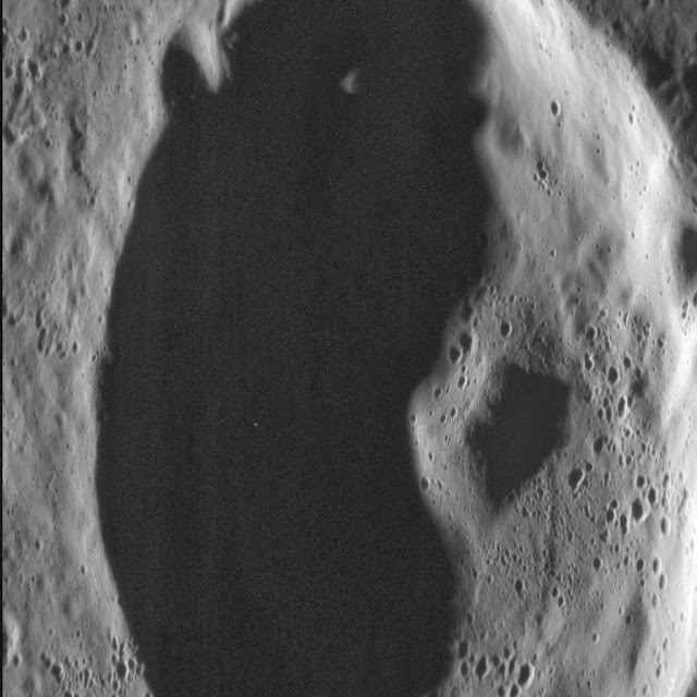
Unnamed Crater in Shadow


In this dramatic scene, an unnamed crater in Mercury's northern volcanic plains is bathed in darkness as the sun sits low on the horizon. Rising from the floor of the crater is its central peak, a small mountain resulting from the crater's formation. A central peak is a type of crater morphology that lies between "simple" and "peak ring" in the range of crater morphology on Mercury.

This image was acquired as a high-resolution targeted observation. Targeted observations are images of a small area on Mercury's surface at resolutions much higher than the 200-meter/pixel morphology base map. It is not possible to cover all of Mercury's surface at this high resolution, but typically several areas of high scientific interest are imaged in this mode each week.

Date acquired: July 07, 2013
Image Mission Elapsed Time (MET): 15510763
Image ID: 4396614
Instrument: Narrow Angle Camera (NAC) of the Mercury Dual Imaging System (MDIS)
Center Latitude: 69.67°
Center Longitude: 1.51° E
Resolution: 16 meters/pixel
Scale: The image is about 23 km (14.3 mi.) from top to bottom
Incidence Angle: 80.3°
Emission Angle: 49.8°
Phase Angle: 130.1°
North is to the bottom right of the image.

Photo credit: NASA/Johns Hopkins University Applied Physics Laboratory/Carnegie Institution of Washington

Saturday, September 7, 2013

Different Views of Erte Crater


Presented here are nine views of the same colorful section of Mercury's surface. The first two rows are eight individual images taken through narrowband color filters with center wavelengths of 433, 480, 559, 629, 748, 829, 898, and 996 nanometers (nm). The color composite on the bottom is shown with the 996, 748, and 433 nm WAC filters for red, green, and blue. Color differences on Mercury are subtle, and no prominent features stand out in examination of the eight individual grey-scale images. However, the bluish nature of the crater rays on the left and the reddish cast of the material surrounding the impact crater Erte at right become apparent when the images are co-registered.

Erte was seen recently in a three-dimensional close-up!

This image was acquired as part of MDIS's 8-color base map. The 8-color base map is composed of WAC images taken through eight different narrow-band color filters and covers more than 99% of Mercury's surface with an average resolution of 1 kilometer/pixel. The highest-quality color images are obtained for Mercury's surface when both the spacecraft and the Sun are overhead, so these images typically are taken with viewing conditions of low incidence and emission angles.

Date acquired: April 22, 2011
Image Mission Elapsed Time (MET): 211937370, 211937378, 211937372
Image ID: 161451, 161456, 161452
Instrument: Wide Angle Camera (WAC) of the Mercury Dual Imaging System (MDIS)
WAC filters: 9, 7, 6 (996, 748, 433 nanometers) in red, green, and blue
Center Latitude: 30.04°
Center Longitude: 239.9° E
Resolution: 798 meters/pixel
Scale: The scene is about 420 km (261 mi.) across
Incidence Angle: 59.5°
Emission Angle: 0.1°
Phase Angle: 59.4°

Photo credit: NASA/Johns Hopkins University Applied Physics Laboratory/Carnegie Institution of Washington

Friday, September 6, 2013

Rude Impact Crater


This view from MESSENGER's Narrow Angle Camera shows the impact crater Rude under morning illumination. The crater has small remnant central peaks that are slightly off-center. A sizable impact crater formed on Rude's floor, possibly causing slumping of Rude's northern rim. Francois Rude was a French sculptor who lived from 1784-1855. His statue of "Mercury Fastening his Sandals" is in the Louvre.

This image was acquired as part of MDIS's high-resolution surface morphology base map. The surface morphology base map covers more than 99% of Mercury's surface with an average resolution of 200 meters/pixel. Images acquired for the surface morphology base map typically are obtained at off-vertical Sun angles (i.e., high incidence angles) and have visible shadows so as to reveal clearly the topographic form of geologic features.

Date acquired: March 04, 2012
Image Mission Elapsed Time (MET): 239375379
Image ID: 1474113
Instrument: Narrow Angle Camera (NAC) of the Mercury Dual Imaging System (MDIS)
Center Latitude: -33.50°
Center Longitude: 280.4° E
Resolution: 180 meters/pixel
Scale: Rude crater is about 67 km (42 mi.) in diameter
Incidence Angle: 81.8°
Emission Angle: 18.4°
Phase Angle: 100.3°

Photo credit: NASA/Johns Hopkins University Applied Physics Laboratory/Carnegie Institution of Washington

Thursday, September 5, 2013

V-Shaped Wrinkle Ridges


This view of a location within Mercury's northern volcanic plains includes a set of wrinkle ridges that form a "V" shape.

This image was acquired as part of MDIS's high-resolution surface morphology base map. The surface morphology base map covers more than 99% of Mercury's surface with an average resolution of 200 meters/pixel. Images acquired for the surface morphology base map typically are obtained at off-vertical Sun angles (i.e., high incidence angles) and have visible shadows so as to reveal clearly the topographic form of geologic features.

Date acquired: October 14, 2011
Image Mission Elapsed Time (MET): 227092494
Image ID: 884412
Instrument: Wide Angle Camera (WAC) of the Mercury Dual Imaging System (MDIS)
WAC filter: 7 (748 nanometers)
Center Latitude: 79.09°
Center Longitude: 352.7° E
Resolution: 140 meters/pixel
Scale: The "V" is about 59 km (37 mi.) long
Incidence Angle: 84.1°
Emission Angle: 28.2°
Phase Angle: 112.3°

Photo credit: NASA/Johns Hopkins University Applied Physics Laboratory/Carnegie Institution of Washington