Friday, March 15, 2013

A Tribute to Messenger


This video showcases a small sampling of the thousands of images taken by the spacecraft, as well as animations illustrating how MESSENGER moves in orbit and how its orbit has changed during the mission.

The opening sequence is from the approach images from the first flyby in 2008. The first animation to follow (at 0:15) shows MESSENGER in its primary mission 12-hour orbit. The relevance of the November 9, 2011, date is that this was when the MESSENGER team was advised that NASA had approved the proposal for an extended mission, allowing the mission to continue making new observations from March 2012 to March 2013. The animation at 0:22 gives you an idea of the movement and gyrations ("dancing") that the spacecraft undergoes while it performs a schedule packed full of observations that take place over one Earth day. The animation sequence at 0:59 gives you a "top down" view over Mercury's north pole from when MESSENGER first went into orbit until several months into the extended mission. The apparent size of the orbit shrinks from the start of the animation to the end, as shortly into the extended mission, MESSENGER's orbital period was shrunk from 12-hours to 8-hours. The animation sequence at 1:44 shows MESSENGER's "dance" on the first day of the extended mission. The other images and embedded movies can be found in the Gallery section of the MESSENGER website.

Some highlight images of note include:

At 0:48 - Blue rays of Bek crater
At 0:54 - Basho crater
At 0:57 - Poe crater in Caloris basin
At 1:17 - MASCS instrument surface scans in ultraviolet and infrared
At 1:19 - A perspective view of the northern polar region, color-coded to MLA topography
At 1:27 - Rembrandt impact basin
At 1:29 - Rembrandt impact basin superimposed on the US for size comparison
At 1:34 - Rachmaninoff impact basin, 3D effect crated using the digital elevation model
At 1:34 - Debussy crater
At 1:58 - Beagle rupes
At 2:04 - Mosaic view of north pole, showing the shadowed regions
At 2:06 - As previous, with superimposed radar data indicating likely water-ice deposits
At 2:11 - A volcanic vent near the edge of Caloris basin
At 2:34 - Derain crater
At 2:36 - Disney crater and two unnamed craters that resemble Mickey Mouse
At 2:38 - Basho crater while the Sun is low in the sky
At 2:40 - Basho crater again, but now with the Sun nearly overhead
At 2:45 - Degas crater
At 2:58 - 'Weird terrain' at the Caloris antipode
At 3:03 - Waters crater with the 'blue tongue' of dark impact melt material
At 3:10 - Seuss crater
At 3:13 - Caloris basin
At 3:15 - Pit in Scarlatti crater, with prominent hollows on the pit rim
At 3:17 - Enhanced color of Caloris basin
At 3:22 - A lava channel that had flowed into the Kofi crater
At 3:29 - More detail of Caloris basin floor
At 3:30 - The young, bright-rayed Mena crater
At 3:37 - Central peaks of Eminescu crater, with hollows around the bases of the peaks
At 3:39 - Apollodorus and Pantheon fossae
At 3:41 - The hollows on the floor of Sander crater

The MESSENGER spacecraft is the first ever to orbit the planet Mercury, and the spacecraft's seven scientific instruments and radio science investigation are unraveling the history and evolution of the Solar System's innermost planet. Visit the Why Mercury? section of this website to learn more about the key science questions that the MESSENGER mission is addressing. During the one-year primary mission, MDIS acquired 88,746 images and extensive other data sets. MESSENGER is now in a year-long extended mission, during which plans call for the acquisition of more than 80,000 additional images to support MESSENGER's science goals.

Video credit: Images and animation stills courtesy NASA/Johns Hopkins University Applied Physics Laboratory/Carnegie Institution of Washington. Music: "Mercury Ridge" by Simon Wilkinson (thebluemask.com). Video creation and time-lapse animations by Mark 'Indy' Kochte.

Thursday, March 14, 2013

Crater Hollows


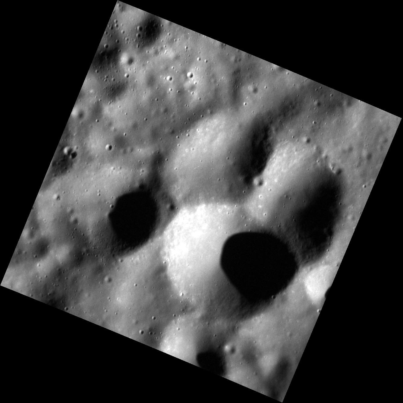
This stunning view shows a host of hollows along the rim and floor of a 42-km-diameter (26-mi-diameter) crater. The hollow-covered rim to the right in this image is shared between this younger, smaller crater and an older, 120-km-diameter (75-mi.-diameter) crater, inside of which the smaller crater formed. The sun was high in the sky when this image was taken, making the bright hollows easy to see. North is to the right.

Date acquired: March 06, 2013
Image Mission Elapsed Time (MET): 4881055
Image ID: 3640892
Instrument: Narrow Angle Camera (NAC) of the Mercury Dual Imaging System (MDIS)
Center Latitude: 25.60°
Center Longitude: 356.2° E
Resolution: 30 meters/pixel
Scale: This crater is approximately 42 km (26 mi.) in diameter.
Incidence Angle: 26.6°
Emission Angle: 52.9°
Phase Angle: 78.2°

Photo credit: NASA/Johns Hopkins University Applied Physics Laboratory/Carnegie Institution of Washington

Wednesday, March 13, 2013

Impact Craters


The large, unnamed crater in this image shares part of its wall with the younger, smaller (42 km/26 mi) unnamed crater that formed inside of it. The floor and rim of the smaller crater contains many hollows, which are difficult to make out in this high-incidence-angle image.

Date acquired: April 14, 2012
Image Mission Elapsed Time (MET): 242883079
Image ID: 1646270
Instrument: Wide Angle Camera (WAC) of the Mercury Dual Imaging System (MDIS)
WAC filter: 7 (748 nanometers)
Center Latitude: 24.62°
Center Longitude: 357.7° E
Resolution: 172 meters/pixel
Scale: The largest crater in this image is approximately 120 km (75 mi.) in diameter.
Incidence Angle: 85.2°
Emission Angle: 42.1°
Phase Angle: 127.4°

Photo credit: NASA/Johns Hopkins University Applied Physics Laboratory/Carnegie Institution of Washington

Tuesday, March 12, 2013

Berkel Crater


Berkel crater, named for Turkish painter and printmaker Sabri Berkel, is a complex crater that sits inside of the larger Ellington basin. Berkel's interior contains material that is darker than the surrounding terrain, as well as hollows, indicating the presence of dark material at depth.

This image was acquired as a targeted set of stereo images. Targeted stereo observations are acquired at resolutions much higher than that of the 200-meter/pixel stereo base map. These targets acquired with the NAC enable the detailed topography of Mercury's surface to be determined for a local area of interest.

Date acquired: February 25, 2013
Image Mission Elapsed Time (MET): 4159492
Image ID: 3589683
Instrument: Narrow Angle Camera (NAC) of the Mercury Dual Imaging System (MDIS)
Center Latitude: -13.85°
Center Longitude: 26.56° E
Resolution: 71 meters/pixel
Scale: Berkel crater is approximately 24 km (15 mi.) in diameter.
Incidence Angle: 30.3°
Emission Angle: 29.3°
Phase Angle: 52.6°

Photo credit: NASA/Johns Hopkins University Applied Physics Laboratory/Carnegie Institution of Washington

Saturday, March 9, 2013

Theophanes Crater


This image shows the crater Theophanes, which was originally imaged by Mariner 10. It is named after the Byzantine iconographer known as Theophanes the Greek. Though he was born in Constantinople, the capitol of the Byzantine Empire, around 1340 CE, Theophanes spent most of his life in Russia, where he moved in 1370 CE. It was in Russia that he gained notoriety as an icon painter. Some of his more prominent works include Our Lady of the Don and the Transfiguration of Christ. He is also known as the teacher and mentor of the great medieval Russian painter Andrei Rublev, the eponym of Rublev crater.

Date acquired: October 03, 2012
Image Mission Elapsed Time (MET): 257735204
Image ID: 2694715
Instrument: Narrow Angle Camera (NAC) of the Mercury Dual Imaging System (MDIS)
Center Latitude: -5.04°
Center Longitude: 217.2° E
Resolution: 74 meters/pixel
Scale: The crater Theophanes has diameter of ~46 km ( 29 mi.).
Incidence Angle: 69.3°
Emission Angle: 2.2°
Phase Angle: 71.6°

Photo credit: NASA/Johns Hopkins University Applied Physics Laboratory/Carnegie Institution of Washington

Friday, March 8, 2013

Degas Crater Rim


This beautiful image shows a segment of the rim of the crater Degas. If you're a devoted MESSENGER follower, then you've no doubt heard all about the floor of Degas. So, let's look a little farther up, shall we? Just outside the rim, i.e. the top half of this image, the texture of the surface changes dramatically. This is the continuous ejecta blanket. This material completely covers the pre-existing terrain. In many instances, the composition of the ejecta blanket is different from the composition of the crater itself. This is because the material that forms the ejecta blanket is some of the deepest material thrown out during the formation of the crater.

Date acquired: October 01, 2012
Image Mission Elapsed Time (MET): 257621391
Image ID: 2686511
Instrument: Narrow Angle Camera (NAC) of the Mercury Dual Imaging System (MDIS)
Center Latitude: 37.60°
Center Longitude: 232.9° E
Resolution: 26 meters/pixel
Scale: This image is ~28 km ( ~17 mi.) across.
Incidence Angle: 65.2°
Emission Angle: 9.5°
Phase Angle: 74.7°

Photo credit: NASA/Johns Hopkins University Applied Physics Laboratory/Carnegie Institution of Washington

Thursday, March 7, 2013

Thrust Fault Scarp on Mercury


The figure above shows an oblique view of a 280 km long scarp. The color scale on this figure represents elevation in which red is high and blue is low. This scarp is interpreted to be a surface-breaking thrust fault. Thrust faults are surface manifestations of the shrinkage of the planet resulting from the cooling of its interior. Notice that the terrain on the left side of the scarp stands about 2 km higher than that of the right side of the scarp. To give you a sense of the scale of this scarp, the state of Delaware has been superposed on the figure.

Center Latitude: 58.18°
Center Longitude: 307.69° E
Scale: The crater that is being cross-cut by this scarp is about 108 km (67 mi.) in diameter.

Illustration credit: NASA/Johns Hopkins University Applied Physics Laboratory/Carnegie Institution of Washington

Wednesday, March 6, 2013

Secondary Craters


This image above shows a common pattern of secondary craters. Secondary craters are formed when blocks of material are thrown out during the formation of an impact crater. The material that impacted the surface to form these secondaries likely originated from the creation of the crater Degas.

Date acquired: November 28, 2012
Image Mission Elapsed Time (MET): 262575756
Image ID: 3038775
Instrument: Narrow Angle Camera (NAC) of the Mercury Dual Imaging System (MDIS)
Center Latitude: 39.68°
Center Longitude: 231.8° E
Resolution: 24 meters/pixel
Scale: This image is ~27 km ( ~17 mi.) across.
Incidence Angle: 61.4°
Emission Angle: 16.6°
Phase Angle: 78.1°

Photo credit: NASA/Johns Hopkins University Applied Physics Laboratory/Carnegie Institution of Washington

Tuesday, March 5, 2013

Balzac Crater


This image shows the crater Balzac. It is named for the French novelist and playwright Honoré de Balzac. Balzac wrote 91 novels and short stories between 1829 and his death in 1850. His novels span several very different genres, including psychological, realistic, fantasy, philosophical, and political novels. Balzac's novels and short stories revealed him to be an extraordinary observer and, therefore, an excellent chronicler of contemporary French society. What a scientist he would have made!

Date acquired: November 27, 2012
Image Mission Elapsed Time (MET): 262546208
Image ID: 3036718
Instrument: Narrow Angle Camera (NAC) of the Mercury Dual Imaging System (MDIS)
Center Latitude: 11.08°
Center Longitude: 215.1° E
Resolution: 55 meters/pixel
Scale: The crater Balzac is ~67 km ( ~42 mi.) in diameter.
Incidence Angle: 36.3°
Emission Angle: 42.3°
Phase Angle: 78.3°

Photo credit: NASA/Johns Hopkins University Applied Physics Laboratory/Carnegie Institution of Washington

Saturday, March 2, 2013

Impact Craters


A pair of craters, each with well-developed central peaks, can be seen in this high-resolution image. In the larger crater, a series of broad central peaks form a ring, while in the smaller, younger crater, one steep central peak dominates the central uplift.

Date acquired: November 26, 2012
Image Mission Elapsed Time (MET): 262402154
Image ID: 3026494
Instrument: Narrow Angle Camera (NAC) of the Mercury Dual Imaging System (MDIS)
Center Latitude: 11.66°
Center Longitude: 245.8° E
Resolution: 48 meters/pixel
Scale: The image is 49 km (30 miles) across.
Incidence Angle: 65.7°
Emission Angle: 0.4°
Phase Angle: 65.3°

Photo credit: NASA/Johns Hopkins University Applied Physics Laboratory/Carnegie Institution of Washington

Friday, March 1, 2013

Impact Crater Near Picasso Crater


The floor of this unnamed crater, located southeast of Picasso crater, exhibits dark material on the southern crater floor at the base of multiple central peaks. Bright hollows cover the tops of the peaks, resembling a white heart on the dark background.

Date acquired: August 01, 2012
Image Mission Elapsed Time (MET): 252323851
Image ID: 2309748
Instrument: Narrow Angle Camera (NAC) of the Mercury Dual Imaging System (MDIS)
Center Latitude: -3.42°
Center Longitude: 54.44° E
Resolution: 98 meters/pixel
Scale: The unnamed large crater is about 35 km (22 miles) across.
Incidence Angle: 28.5°
Emission Angle: 17.1°
Phase Angle: 45.6°

Photo credit: NASA/Johns Hopkins University Applied Physics Laboratory/Carnegie Institution of Washington

Thursday, February 28, 2013

Nobokov Crater


The crater Nobokov exhibits a rugged basin ring and degraded crater rim. The inset color image suggests that the basin floor may be of a slightly different composition than the surrounding material. The inset color image is a composite of the MDIS Wide Angle Camera filters with the 1000-nm filter depicted in red, the 750-nm filter depicted in green, and the 430-nm filter depicted in blue. The blueish hue in the color image reveals that Nabokov has a slightly shallower spectral slope than many of the younger volcanic terrains on Mercury.

Date acquired: January 10, 2012
Image Mission Elapsed Time (MET): 234661409
Image ID: 1246800
Instrument: Narrow Angle Camera (NAC) of the Mercury Dual Imaging System (MDIS)
Center Latitude: -14.57°
Center Longitude: 55.18° E
Resolution: 137 meters/pixel
Scale: Nabokov crater is 166 km (103 mi.) across.
Incidence Angle: 62.7°
Emission Angle: 2.2°
Phase Angle: 60.5°

Photo credit: NASA/Johns Hopkins University Applied Physics Laboratory/Carnegie Institution of Washington

Wednesday, February 27, 2013

Fresh Impact Crater


This high-resolution image reveals the shape of a small, fresh crater on Mercury. In the inset color image, which is a composite of the MDIS Wide Angle Camera filters with the 1000-nm filter depicted in red, the 750-nm filter depicted in green, and the 430-nm filter depicted in blue, this crater is so bright relative to the surroundings that it appears to be close to the same size as the crater to its west. However, from this main image, it is clear that this bright crater is less than half the size of its neighbor. Small craters like this are extremely valuable scientifically, as they excavate material that has been sheltered from the harsh space environment and what is known as space weathering. By studying their spectral properties, scientists can begin to understand both the composition of the surface and how space weathering alters the uppermost surface of the planet.

Date acquired: August 02, 2011
Image Mission Elapsed Time (MET): 220762382
Image ID: 581250
Instrument: Narrow Angle Camera (NAC) of the Mercury Dual Imaging System (MDIS)
Center Latitude: 42.37°
Center Longitude: 8.06° E
Resolution: 45 meters/pixel
Scale: The small, fresh crater is about 3.5 km (2.2 miles) across
Incidence Angle: 67.2°
Emission Angle: 57.0°
Phase Angle: 124.2°

Photo credit: NASA/Johns Hopkins University Applied Physics Laboratory/Carnegie Institution of Washington

Tuesday, February 26, 2013

Chao Meng-Fu Crater


Because of the small axial tilt of Mercury's pole of rotation, several of the craters in this south polar image are shrouded in permanent shadow. Earth-based radar observations have found that these craters also host radar-bright material that is likely water ice. In the furthest southern portion of this image, the rim of the large crater Chao Meng-Fu rises from the darkness.

Date acquired: September 07, 2011
Image Mission Elapsed Time (MET): 223925708
Image ID: 730957
Instrument: Narrow Angle Camera (NAC) of the Mercury Dual Imaging System (MDIS)
Center Latitude: -86.25°
Center Longitude: 303.9° E
Resolution: 268 meters/pixel
Scale: The image is 385 kilometers (239 miles) from corner to corner.
Incidence Angle: 87.9°
Emission Angle: 7.1°
Phase Angle: 80.8°

Photo credit: NASA/Johns Hopkins University Applied Physics Laboratory/Carnegie Institution of Washington

Sunday, February 24, 2013

Mercury


The view shown here is similar to an earlier one, posted in October 2011, but now the coverage is more complete. The globe on the left was created from the MDIS monochrome surface morphology base map campaign. The globe on the right was produced from the MDIS color base map campaign. Each map is composed of thousands of images, and the color view was created by using 3 of the 8 color filters acquired. (1000, 750, and 430 nm wavelengths are displayed in red, green, and blue, respectively.) On March 8, 2013, these global maps will be publicly released at full resolution by NASA's Planetary Data System.

Instrument: Mercury Dual Imaging System (MDIS)
Center Latitude:
Center Longitude: 75° E
Scale: Mercury's diameter is 4880 kilometers (3030 miles).
Map Projection: orthographic

Image credit: NASA/Johns Hopkins University Applied Physics Laboratory/Carnegie Institution of Washington

Saturday, February 23, 2013

Prokofiev Crater


Prokofiev, named in August 2012 for the Russian composer, is the largest crater in Mercury's north polar region to host radar-bright material. MESSENGER has found evidence that within the cold, dark, permanently shadowed regions of Prokofiev, water ice is exposed on the surface.

Date acquired: January 07, 2013
Image Mission Elapsed Time (MET): 266090610
Image ID: 3288616
Instrument: Wide Angle Camera (WAC) of the Mercury Dual Imaging System (MDIS)
WAC filter: 2 (700 nanometers)
Center Latitude: 84.90°
Center Longitude: 68.75° E
Resolution: 79 meters/pixel
Scale: Prokofiev has a diameter of 112 kilometers (70 miles).
Incidence Angle: 84.9°
Emission Angle: 6.1°
Phase Angle: 78.8°

Photo credit: NASA/Johns Hopkins University Applied Physics Laboratory/Carnegie Institution of Washington

Friday, February 22, 2013

Xiao Zhao Crater


The crater shown here is Xiao Zhao, a relatively young crater with a prominent system of bright rays. This image is extremely similar to one acquired previously, and that is by design. Certain features, like Xiao Zhao and locations with hollows, are being repeatedly imaged to look for any slight hints of change.

Date acquired: December 19, 2012
Image Mission Elapsed Time (MET): 264389643
Image ID: 3167776
Instrument: Narrow Angle Camera (NAC) of the Mercury Dual Imaging System (MDIS)
Center Latitude: 10.64°
Center Longitude: 123.9° E
Resolution: 58 meters/pixel
Scale: Xiao Zhao has a diameter of 24 kilometers (15 miles).
Incidence Angle: 20.3°
Emission Angle: 40.8°
Phase Angle: 58.5°

Photo credit: NASA/Johns Hopkins University Applied Physics Laboratory/Carnegie Institution of Washington

Thursday, February 21, 2013

Mercury's Limb Near the Caloris Basin


This striking view is located near the rim of the large Caloris basin. The rim of Caloris is marked by hills and mountains, some of which can be seen in the distance in this image.

This image was acquired as part of MDIS's limb imaging campaign. Once per week, MDIS captures images of Mercury's limb, with an emphasis on imaging the southern hemisphere limb. These limb images provide information about Mercury's shape and complement measurements of topography made by the Mercury Laser Altimeter (MLA) of Mercury's northern hemisphere.

Date acquired: December 18, 2012
Image Mission Elapsed Time (MET): 264299214
Image ID: 3161641
Instrument: Narrow Angle Camera (NAC) of the Mercury Dual Imaging System (MDIS)
Center Latitude:
Center Longitude: 149° E
Additional Location Information: The mountain on the horizon on the left side of the image is at roughly 13°, 152° E
Scale: The bottom of this image is about 210 kilometers (130 miles) across.

Photo credit: NASA/Johns Hopkins University Applied Physics Laboratory/Carnegie Institution of Washington

Wednesday, February 20, 2013

Mercury, Enhanced (2)


This colorful view of Mercury was produced by using images from the color base map imaging campaign during MESSENGER's primary mission. These colors are not what Mercury would look like to the human eye, but rather the colors enhance the chemical, mineralogical, and physical differences between the rocks that make up Mercury's surface.

Young crater rays, extending radially from fresh impact craters, appear light blue or white. Medium- and dark-blue areas are a geologic unit of Mercury's crust known as the "low-reflectance material", thought to be rich in a dark, opaque mineral. Tan areas are plains formed by eruption of highly fluid lavas. The crater in the upper right whose rays stretch across the planet is Hokusai.

To see the other side of the planet view this image.

To watch a movie of this colorful view of Mercury as a spinning globe click here or visit the mission's Movie Page.

Instrument: Wide Angle Camera (WAC) of the Mercury Dual Imaging System (MDIS)
Center Latitude:
Center Longitude: 320° E
Scale: Mercury's diameter is 4880 kilometers (3030 miles)
Map Projection: orthographic

Image credit: NASA/Johns Hopkins University Applied Physics Laboratory/Carnegie Institution of Washington

Tuesday, February 19, 2013

Mercury, Enhanced (1)


This colorful view of Mercury was produced by using images from the color base map imaging campaign during MESSENGER's primary mission. These colors are not what Mercury would look like to the human eye, but rather the colors enhance the chemical, mineralogical, and physical differences between the rocks that make up Mercury's surface.

Young crater rays, extending radially from fresh impact craters, appear light blue or white. Medium- and dark-blue areas are a geologic unit of Mercury's crust known as the "low-reflectance material", thought to be rich in a dark, opaque mineral. Tan areas are plains formed by eruption of highly fluid lavas. The giant Caloris basin is the large circular tan feature located just to the upper right of center of the image.

To see the other side of the planet view this image.

To watch a movie of this colorful view of Mercury as a spinning globe click here or visit the mission's Movie Page.

Instrument: Wide Angle Camera (WAC) of the Mercury Dual Imaging System (MDIS)
Center Latitude:
Center Longitude: 140° E
Scale: Mercury's diameter is 4880 kilometers (3030 miles)
Map Projection: orthographic

Image credit: NASA/Johns Hopkins University Applied Physics Laboratory/Carnegie Institution of Washington

Sunday, February 17, 2013

Rachmaninoff Impact Basin


This is a still image taken from a rotating movie of Mercury's Rachmaninoff impact basin. An enhanced-color image has been draped over a digital elevation model of the surface. The vertical exaggeration is 7 times. The basin's outer rim is about 306 km in diameter and the inner (peak) ring is about 140 km in diameter. The smooth plains within the center appear tan in this presentation, emphasizing their compositional contrast with the dark, bluer rocks that form the peak ring mountains. Images from the Mercury Dual Imaging System on board NASA's MESSENGER spacecraft were processed to provide the color and elevation information used to create this view.

The color base map shown here consists of MDIS images taken through eight different color filters. It is part of a global color map that covers more than 99% of Mercury's surface with an average resolution of about 1 kilometer per pixel.

Instrument: Wide Angle Camera (WAC) of the Mercury Dual Imaging System (MDIS)
Center Latitude: 27.8°
Center Longitude: 58° E

Image credit: NASA/Johns Hopkins University Applied Physics Laboratory/Carnegie Institution of Washington

Note: For a video showing a 360-degree view of this impact basin, click here.

Saturday, February 16, 2013

Mercury Global Map


A global color map of Mercury's surface has been created by mosaicking thousands of sets of images obtained by the MESSENGER Wide Angle Camera (WAC). The colors shown here are related to variations in the spectral reflectance across the planet. This view captures both compositional differences and differences in how long materials have been exposed at Mercury's surface. Young crater rays, arrayed radially around fresh impact craters, appear light blue or white. Medium- and dark-blue areas are a geologic unit of Mercury's crust known as the "low-reflectance material," thought to be rich in a dark, opaque mineral. Tan areas are plains formed by eruption of highly fluid lavas. The large circular area near the top center is the Caloris impact basin, whose interior is filled with smooth, somewhat younger volcanic plains. Small orangish spots are materials deposited by explosive volcanic eruptions.

The color base map shown here consists of MDIS images taken through eight different color filters. It is part of a global color map that covers more than 99% of Mercury's surface with an average resolution of about 1 kilometer per pixel.

Instrument: Wide Angle Camera (WAC) of the Mercury Dual Imaging System (MDIS). This is an enhanced-color presentation created from a statistical combination of images taken through eight of the WAC filters.

Video credit: NASA/Johns Hopkins University Applied Physics Laboratory/Carnegie Institution of Washington; text credit: NASA/Johns Hopkins University Applied Physics Laboratory/Carnegie Institution of Washington

Note: Available on the original NASA webpage are two different size maps available for download: a smaller 6.5 MB video and a larger 23 MB video.

Friday, February 15, 2013

Stieglitz Crater


At the bottom of this image is a part of the rim of crater Stieglitz. Alfred Stieglitz was an American photographer who lived from 1864 to 1946. His wife, painter Georgia O'Keeffe, is honored by a crater on the planet Venus.

Date acquired: July 21, 2011
Image Mission Elapsed Time (MET): 219733996
Image ID: 532053
Instrument: Wide Angle Camera (WAC) of the Mercury Dual Imaging System (MDIS)
WAC filter: 7 (748 nanometers)
Center Latitude: 74.73°
Center Longitude: 66.86° E
Resolution: 108 meters/pixel
Scale: The crater at the top of the image is about 26 km (16 mi.) in diameter.
Incidence Angle: 78.3°
Emission Angle: 0.2°
Phase Angle: 78.3°

Photo credit: NASA/Johns Hopkins University Applied Physics Laboratory/Carnegie Institution of Washington

Tuesday, February 12, 2013

Ahmad Baba Basin


Today's image is a view of Ahmad Baba, a classic Mercurian peak-ring basin. Ahmad (Ahmed) Baba was a West African writer who lived from 1556-1627. The Malian city of Timbuktu is home to the Ahmed Baba Institute, a library and research center named in his honor. The Institute is home to over 18,000 ancient manuscripts.

Date acquired: December 14, 2011
Image Mission Elapsed Time (MET): 232373246
Image ID: 1136317
Instrument: Wide Angle Camera (WAC) of the Mercury Dual Imaging System (MDIS)
WAC filter: 7 (748 nanometers)
Center Latitude: 58.43°
Center Longitude: 231.7° E
Resolution: 250 meters/pixel
Scale: The basin's main ring is about 126 km (78 mi.) in diameter.
Incidence Angle: 71.5°
Emission Angle: 0.5°
Phase Angle: 71.0°

Photo credit: NASA/Johns Hopkins University Applied Physics Laboratory/Carnegie Institution of Washington

Saturday, February 9, 2013

Southern Hemisphere Craters


The set of images shown here in color was acquired as part of a sequence intended to monitor any changes in the calibration of the multispectral Wide Angle Camera over time, but it also gives a beautiful view of Mercury's cratered southern hemisphere. The craters Magritte, Neruda, and Sher-Gil can be spotted within this scene. North is to the top-left of the image.

Date acquired: December 17, 2012
Image Mission Elapsed Time (MET): 264237810, 264237814, 264237830
Image ID: 3157538, 3157539, 3157543
Instrument: Wide Angle Camera (WAC) of the Mercury Dual Imaging System (MDIS)
WAC filters: 9, 7, and 6 (996, 748, and 433 nanometers) in red, green, and blue
Center Latitude: -59.16°
Center Longitude: 149.3° E
Resolution: 1,663 meters/pixel
Scale: This scene is over 1,900 km (1,180 mi.) across
Incidence Angle: 59.2°
Emission Angle: 28.8°
Phase Angle: 78.1°

Photo credit: NASA/Johns Hopkins University Applied Physics Laboratory/Carnegie Institution of Washington

Friday, February 8, 2013

Peaks from an Unnamed Crater


The central peaks of an unnamed 38-km crater fill this scene. The sun is coming from the left side of the frame, so that the peaks cast their shadows to the right. North is to the right in this image.

Date acquired: December 15, 2012
Image Mission Elapsed Time (MET): 264103036
Image ID: 3147414
Instrument: Narrow Angle Camera (NAC) of the Mercury Dual Imaging System (MDIS)
Center Latitude: 76.84°
Center Longitude: 139.9° E
Resolution: 12 meters/pixel
Scale: This scene is 13 km (8 mi.) across
Incidence Angle: 77.0°
Emission Angle: 12.6°
Phase Angle: 71.2°

Photo credit: NASA/Johns Hopkins University Applied Physics Laboratory/Carnegie Institution of Washington

Thursday, February 7, 2013

Atget Crater


Though Mercury is not known for having an especially colorful surface, some regions show a strong local contrast in color. Like other craters in Caloris, the interior and ejecta of Atget are darker and bluer than the typical brown volcanic plains. These craters help scientists to get a look at the three-dimensional compositional variations with the Caloris basin, and provide a way to judge the thickness of the volcanic plains (over 2 km here!). North is up in this image.

Date acquired: December 09, 2012
Image Mission Elapsed Time (MET): 263555174, 263555178, 263555194
Image ID: 3108404, 3108405, 3108409
Instrument: Wide Angle Camera (WAC) of the Mercury Dual Imaging System (MDIS)
WAC filters: 9, 7, and 6 (996, 748, and 433 nanometers) in red, green, and blue
Center Latitude: 25.92°
Center Longitude: 166.2° E
Resolution: 224 meters/pixel
Scale: Atget is 100 km (62 mi.) in diameter
Incidence Angle: 25.9°
Emission Angle: 52.6°
Phase Angle: 78.5°

Photo credit: NASA/Johns Hopkins University Applied Physics Laboratory/Carnegie Institution of Washington

Wednesday, February 6, 2013

Sibelius Crater


The central peaks of Sibelius crater are not actually so central, but instead are offset to the southwestern side of the crater. The smooth, flat surfaces surrounding the peaks are composed of solidified impact melt, which pooled in the crater floor and outside the rim but is concentrated to the northeast. These observations suggest that the impactor that formed Sibelius came at an oblique angle from the southwest, with central peaks offset up-range and melt splashing out of the crater down-range. The crater is still largely circular, as only the very shallowest impact angles result in oblique craters such as Hovnatanian. North is up in this image.

Date acquired: December 05, 2012
Image Mission Elapsed Time (MET): 263234346
Image ID: 3085867
Instrument: Narrow Angle Camera (NAC) of the Mercury Dual Imaging System (MDIS)
Center Latitude: -48.83°
Center Longitude: 213.9° E
Resolution: 155 meters/pixel
Scale: Sibelius crater is 92 km (57 mi.) in diameter
Incidence Angle: 60.3°
Emission Angle: 35.9°
Phase Angle: 32.8°

Photo credit: NASA/Johns Hopkins University Applied Physics Laboratory/Carnegie Institution of Washington

Tuesday, February 5, 2013

Crater in Caloris Basin


You may have noticed that one of the details we give for each image is the Mission Elapsed Time, or MET, of when it was acquired. MET is the time, in seconds, since the MESSENGER mission began in 2004. As a testament to how long MESSENGER has been in space (over eight years!), the number of seconds has added up to over 250 million, and has come close to reaching the limit of how high the spacecraft clock can count. Thus in January, the MESSENGER team reset the clock, starting over at a time of 1,000 seconds. Why 1,000 seconds rather than zero? The MET clock was originally set to start counting 1,000 seconds before launch, so that launch was actually at an MET of 1,000 rather than zero; the clock reset follows that precedent.

Today's image was acquired at an "MET" of 129,781 seconds, or a day and a half after the count started over. This image shows an interesting crater in the Caloris basin. Craters of irregular shape are often thought to be formed from processes other than impact events, but this crater could be a cluster of several smaller craters or its shape could have been modified by the wrinkle ridge that crosses the scene from northwest to southeast. North is up in this image.

Date acquired: January 10, 2013
Image Mission Elapsed Time (MET): 129781
Image ID: 3302953
Instrument: Narrow Angle Camera (NAC) of the Mercury Dual Imaging System (MDIS)
Center Latitude: 28.08°
Center Longitude: 144.6° E
Resolution: 28 meters/pixel
Scale: This scene is approximately 28 km (17 mi.) across
Incidence Angle: 77.1°
Emission Angle: 0.7°
Phase Angle: 76.4°

Photo credit: NASA/Johns Hopkins University Applied Physics Laboratory/Carnegie Institution of Washington

Saturday, February 2, 2013

Kipling Crater


The Kipling crater was originally circular, but that changed when the crater in this image was formed. Situated atop (and so postdating) the southern margin of Kipling, this smaller, younger crater has a distinctive central peak that is encircled by a curious, near-circular depression. This depression may be a volcanic pit, like others that dot the surface Mercury -- one of which even occurs in Kipling. The smooth floor of this crater shows subtle evidence of tectonic deformation, like that seen in many other infilled craters across the planet.

Date acquired: January 03, 2012
Image Mission Elapsed Time (MET): 234068866
Image ID: 1218101
Instrument: Narrow Angle Camera (NAC) of the Mercury Dual Imaging System (MDIS)
Center Latitude: -20.83°
Center Longitude: 73.02° E
Resolution: 104 meters/pixel
Scale: This crater is ~88 km (55 mi.) in diameter
Incidence Angle: 67.2°
Emission Angle: 58.7°
Phase Angle: 28.2°
North is to the bottom-right corner of this image.

Photo credit: NASA/Johns Hopkins University Applied Physics Laboratory/Carnegie Institution of Washington

Friday, February 1, 2013

Low Scarp


The surface of Mercury has been extensively deformed by tectonic activity, with most of that activity due to the global-scale contraction of the planet as its interior cooled. This tectonic deformation is largely manifest as contractional lobate scarps, many of which are hundreds or even thousands of meters high. This image shows a scarp only ~150 m (500 ft.) high, considerably smaller than many of its peers across the planet. This structure's relatively small size suggests either that it accommodated but a relatively small amount of deformation over its lifetime, or that it is one of the youngest lobate scarps on Mercury.

Date acquired: April 04, 2012
Image Mission Elapsed Time (MET): 234154717
Image ID: 1222306
Instrument: Narrow Angle Camera (NAC) of the Mercury Dual Imaging System (MDIS)
Center Latitude: 29.31°
Center Longitude: 91.01° E
Resolution: 46 meters/pixel
Scale: The crater to the top right is ~18 km (11 mi.) in diameter
Incidence Angle: 51.6°
Emission Angle: 14.5°
Phase Angle: 38.1°
North is to the bottom-right corner of this image.

Photo credit: NASA/Johns Hopkins University Applied Physics Laboratory/Carnegie Institution of Washington

Thursday, January 31, 2013

Impact Melt in Raditladi Basin


We have seen the ejecta deposit of the Raditladi basin before, but not at this resolution. Here, the smooth patches of surface are solidified ponds of impact melt, rock liquefied by the tremendous heat of the impact explosion that formed Raditladi. The rougher, higher-standing terrain is either solid ejecta deposited around the impact site, or part of the original surface that predates the basin's formation.

Date acquired: November 19, 2012
Image Mission Elapsed Time (MET): 261770877
Image ID: 2981602
Instrument: Narrow Angle Camera (NAC) of the Mercury Dual Imaging System (MDIS)
Center Latitude: 29.06°
Center Longitude: 115.13° E
Resolution: 27 meters/pixel
Scale: The field of view is ~25 km (16 mi.) from top to bottom
Incidence Angle: 68.0°
Emission Angle: 27.4°
Phase Angle: 95.4°
North is to the bottom of this image.

Photo credit: NASA/Johns Hopkins University Applied Physics Laboratory/Carnegie Institution of Washington

Wednesday, January 30, 2013

Counting Craters


Counting craters on Mercury is a serious job, as the density of craters on the surface of a planet can be used to indicate its age; the more craters present, the older the surface. Although this technique is commonly used on planetary bodies throughout the Solar System, crater counting on Mercury is particularly challenging. Secondary craters are formed by debris thrown out during an impact, and are often big enough to be confused with primary craters. Their inclusion in crater-counting studies, however, would skew derived age results for a surface, making it appear older than it really is, and so care must be taken when deciding which craters to count, and which to leave out.

Date acquired: November 05, 2012
Image Mission Elapsed Time (MET): 260592647
Image ID: 2897484
Instrument: Narrow Angle Camera (NAC) of the Mercury Dual Imaging System (MDIS)
Center Latitude: -37.74°
Center Longitude: 194.02° E
Resolution: 117 meters/pixel
Scale: The crater just left of upper center is ~20 km (12 mi.) in diameter
Incidence Angle: 37.9°
Emission Angle: 4.6°
Phase Angle: 38.7°
North is to the right of this image

Photo credit: NASA/Johns Hopkins University Applied Physics Laboratory/Carnegie Institution of Washington

Tuesday, January 29, 2013

Crater Cliff


The floor of the Caloris basin consists of smooth, volcanic plains -- but these plains have been modified by subsequent impacts and tectonic deformation. This crater, which is located not only on the Caloris interior plains but half-covers its neighbor, has a sharp, well-preserved rim and internal terraces. The floor of the crater is some 900 m (~0.5 mi.) below the rim, making this crater's wall quite a cliff indeed.

Date acquired: November 08, 2012
Image Mission Elapsed Time (MET): 260906527
Image ID: 1222306
Instrument: Narrow Angle Camera (NAC) of the Mercury Dual Imaging System (MDIS)
Center Latitude: 29.31°
Center Longitude: 91.0° E
Resolution: 21 meters/pixel
Scale: The field of view is ~20 km (12 mi.) across
Incidence Angle: 40.1°
Emission Angle: 8.5°
Phase Angle: 48.7°
North is to the right of this image.

Photo credit: NASA/Johns Hopkins University Applied Physics Laboratory/Carnegie Institution of Washington

Saturday, January 26, 2013

Kertesz Crater


This spectacular image is a mosaic of three separate NAC frames. It gives us a close-up look at the enigmatic Kertesz crater and its extensive system of hollows.

Date acquired: January 11, 2013
Image Mission Elapsed Time (MET) Since 8 January, 2013: 187422, 187426, 187430
Image ID: 3307043, 3307044, 3307045
Instrument: Narrow Angle Camera (NAC) of the Mercury Dual Imaging System (MDIS)
Center Latitude: 27.38°
Center Longitude: 146.3° E
Resolution: 30 meters/pixel
Scale: Kertesz crater is approximately 31 km (19 mi.) in diameter.
Incidence Angle: 80.5°
Emission Angle: 16.2°
Phase Angle: 64.3°

Photo credit: NASA/Johns Hopkins University Applied Physics Laboratory/Carnegie Institution of Washington

Friday, January 25, 2013

Michelangelo Impact Basin


Here, the peak-ringed Michelangelo basin is seen close to the terminator. Hawthorne crater (outside this image field of view past the upper right corner) may be the source of the secondary crater chains that cross through the basin. North is towards the bottom of this image.

Date acquired: March 26, 2012
Image Mission Elapsed Time (MET): 241236952
Image ID: 1566240
Instrument: Narrow Angle Camera (NAC) of the Mercury Dual Imaging System (MDIS)
Center Latitude: -44.13°
Center Longitude: 251.5° E
Resolution: 369 meters/pixel
Scale: Michelangelo basin is approximately 230 km (143 mi.) in diameter.
Incidence Angle: 83.6°
Emission Angle: 37.6°
Phase Angle: 67.5°

Photo credit: NASA/Johns Hopkins University Applied Physics Laboratory/Carnegie Institution of Washington

Thursday, January 24, 2013

Grainger Crater


Grainger crater, seen at the bottom of this image, exhibits a tall central peak and interesting color features, including low-reflectance material and hollows. Grainger crater was named in 2012 for Australian composer, arranger, and pianist Percy Grainger (1882-1961), many of whose compositions are considered standards of the wind symphony/military band genre.

Date acquired: January 30, 2012
Image Mission Elapsed Time (MET): 236408235
Image ID: 1330758
Instrument: Narrow Angle Camera (NAC) of the Mercury Dual Imaging System (MDIS)
Center Latitude: -42.90°
Center Longitude: 105.3° E
Resolution: 119 meters/pixel
Scale: Grainger crater is approximately 113 km (70 mi.) in diameter.
Incidence Angle: 65.3°
Emission Angle: 16.7°
Phase Angle: 81.7°

Photo credit: NASA/Johns Hopkins University Applied Physics Laboratory/Carnegie Institution of Washington

Wednesday, January 23, 2013

Disney Crater


MESSENGER went viral in 2012 when it spotted Mickey Mouse on Mercury! The largest of this coincidental collection of craters (Mickey's head), seen towards the top of this image, was recently named in honor of American film maker, actor, animator Walt Disney (1901-1966). North is down in this image.

Date acquired: July 20, 2011
Image Mission Elapsed Time (MET): 219617891
Image ID: 525880
Instrument: Narrow Angle Camera (NAC) of the Mercury Dual Imaging System (MDIS)
Center Latitude: -66.68°
Center Longitude: 101.7° E
Resolution: 309 meters/pixel
Scale: Disney crater is approximately 113 km (70 mi.) in diameter.
Incidence Angle: 66.9°
Emission Angle: 33.6°
Phase Angle: 100.6°

Photo credit: NASA/Johns Hopkins University Applied Physics Laboratory/Carnegie Institution of Washington

Tuesday, January 22, 2013

Ellington Basin and Berkel Crater


Ellington basin, named in 2012 for American jazz legend Duke Ellington (1899-1974), is a peak ring basin covered in secondary craters. The prominent crater Berkel lies inside of the basin. Berkel's ejecta and floor exhibit differences in reflectance and color, indicating a heterogeneous local stratigraphy. This image was created by merging a color image with a monochrome image, in order to emphasize both the topography and the color of the area.

Date acquired: August 07, 2012
Image Mission Elapsed Time (MET): 252814064, 252814056, 252814060
Image ID: 2344652, 2344650, 2344651
Instrument: Wide Angle Camera (WAC) of the Mercury Dual Imaging System (MDIS)
WAC filters: 9, 7, 6 (996, 748, 433 nanometers) in red, green, and blue
Center Latitude: -14.85°
Center Longitude: 25.55° E
Resolution: 476 meters/pixel
Scale: Ellington basin is 216 km (134 mi.) in diameter.
Incidence Angle: 19.3°
Emission Angle: 8.7°
Phase Angle: 28.0°

Photo credit: NASA/Johns Hopkins University Applied Physics Laboratory/Carnegie Institution of Washington

Saturday, January 19, 2013

Poe Crater


For as long as 70 years, a visitor to the original grave site of Edgar Allan Poe left a tribute in the form of roses and a bottle of cognac each January 19 (Poe's birthday). The "Poe Toaster" has not appeared since 2009, and it appears that the tradition has ended. Here we offer our own toast to the great American writer: a color view of Poe crater on Mercury. In this representation, Poe's raven-colored rim stands out from the tan volcanic plains that surround it. Tiny hollows speckle the dark rim like blue-white stars in the blackness of night. This sinfully scintillant planet/From the Hell of the planetary souls.

Date acquired: July 03, 2011
Image Mission Elapsed Time (MET): 218204194, 218204190, 218204186
Image ID: 458399, 458398, 458397
Instrument: Wide Angle Camera (WAC) of the Mercury Dual Imaging System (MDIS)
WAC filters: 9, 7, 6 (996, 748, 433 nanometers) in red, green, and blue.
Center Latitude: 42.83°
Center Longitude: 158.9° E
Resolution: 213 meters/pixel
Scale: Poe crater is about 77 km (48 mi.) in diameter.
Incidence Angle: 42.8°
Emission Angle: 35.9°
Phase Angle: 78.7°

Photo credit: NASA/Johns Hopkins University Applied Physics Laboratory/Carnegie Institution of Washington

Friday, January 18, 2013

Young Impact Crater


This image, taken with the Narrow Angle Camera (NAC), shows an unnamed complex crater in Mercury's southern hemisphere. The sharpness of the terraced walls and central peaks indicate that the crater is relatively young. Also visible is a secondary crater chain that crosses the northern half of the crater floor, most likely created by the ejecta of an impact outside of the field of view.

Date acquired: December 17, 2012
Image Mission Elapsed Time (MET): 264215266
Image ID: 3155492
Instrument: Narrow Angle Camera (NAC) of the Mercury Dual Imaging System (MDIS)
Center Latitude: -23.01°
Center Longitude: 112.1° E
Resolution: 205 meters/pixel
Scale: This crater is about 75 km (47 mi.) in diameter.
Incidence Angle: 41.0°
Emission Angle: 1.6°
Phase Angle: 39.4°

Photo credit: NASA/Johns Hopkins University Applied Physics Laboratory/Carnegie Institution of Washington

Wednesday, January 16, 2013

Cloverleaf Craters


This very high resolution image features three impact craters of nearly the same size that overlap to form a cloverleaf pattern. All three have rounded rims, indicating that they are relatively old. Determining the sequence of events is difficult. It may be that the one at the bottom formed most recently, blasting away sections of the rims of the other two.

Date acquired: February 26, 2012
Image Mission Elapsed Time (MET): 238781474
Image ID: 1445431
Instrument: Narrow Angle Camera (NAC) of the Mercury Dual Imaging System (MDIS)
Center Latitude: 48.76°
Center Longitude: 298.0° E
Resolution: 13 meters/pixel
Scale: The scene is about 14 km (9 mi.) across.
Incidence Angle: 71.7°
Emission Angle: 0.1°
Phase Angle: 71.7°

Photo credit: NASA/Johns Hopkins University Applied Physics Laboratory/Carnegie Institution of Washington

Tuesday, January 15, 2013

Raditladi Basin


This image, taken with the Wide Angle Camera (WAC), shows the outer rim and inner peak ring of Raditladi basin. The basin's smooth floor and well-preserved peak ring structure indicate that Raditladi is relatively young. The concentric troughs along the floor near the basin's center formed by extension (pulling apart) of the surface and are similar to those seen in Caloris basin and Rembrandt basin. The bright areas around the peak ring are an excellent example of hollows, shallow depressions that may have been formed by the loss of volatile materials.

Date acquired: December 17, 2012
Image Mission Elapsed Time (MET): 264246178
Image ID: 3157599
Instrument: Wide Angle Camera (WAC) of the Mercury Dual Imaging System (MDIS)
WAC filter: 7 (748 nanometers)
Center Latitude: 26.29°
Center Longitude: 119.1° E
Resolution: 228 meters/pixel
Scale: Raditladi basin has a diameter of 257 kilometers (160 miles)
Incidence Angle: 36.9°
Emission Angle: 9.0°
Phase Angle: 45.9°

Photo credit: NASA/Johns Hopkins University Applied Physics Laboratory/Carnegie Institution of Washington

Monday, January 14, 2013

Mendelssohn Impact Basin Rim


This image shows a southern portion of the Mendelssohn impact basin. The smooth plains in the top (north) half of the image contrast sharply with the rugged, heavily cratered geological unit that forms the basin rim. The smooth plains were formed by eruption of highly fluid lavas that covered the basin floor. The Sun was low on the horizon when the image was captured, and the resulting shadows reveal the presence of ridges in the plains that mark the rims of impact craters buried by the lavas.

Date acquired: December 05, 2011
Image Mission Elapsed Time (MET): 231567383
Image ID: 1097256
Instrument: Wide Angle Camera (WAC) of the Mercury Dual Imaging System (MDIS)
WAC filter: 7 (748 nanometers)
Center Latitude: 67.16°
Center Longitude: 99.57° E
Resolution: 95 meters/pixel
Scale: The scene is about 124 km (77 mi.) across.
Incidence Angle: 86.3°
Emission Angle: 37.5°
Phase Angle: 123.9°

Photo credit: NASA/Johns Hopkins University Applied Physics Laboratory/Carnegie Institution of Washington

Sunday, January 13, 2013

Ray Systems East of Bronte Crater


Today's image shows a complicated area of rays to the east of crater Bronte (named for sisters Charlotte, Emily, and Anne Bronte, and their brother Branwell). The rays trending roughly northeast-southwest originated from Degas, which formed just touching Bronte's rim. The roughly north-south ray (and secondary crater chain) on the right side of the image was probably formed by ejecta that came over the pole from Hokusai.

Date acquired: April 22, 2011
Image Mission Elapsed Time (MET): 211981114
Image ID: 163497
Instrument: Wide Angle Camera (WAC) of the Mercury Dual Imaging System (MDIS)
WAC filter: 7 (748 nanometers)
Center Latitude: 38.15°
Center Longitude: 238.4° E
Resolution: 322 meters/pixel
Scale: The edges of the image are about 330 km (205 mi.) long.
Incidence Angle: 62.4°
Emission Angle: 0.2°
Phase Angle: 62.5°

Photo credit: NASA/Johns Hopkins University Applied Physics Laboratory/Carnegie Institution of Washington

Saturday, January 12, 2013

Southern Caloris Basin Ring of Fire


Here is a color view of the southern part of the Caloris basin. Extending along the southern rim are a number of pyroclastic deposits that have a distinctive reddish color. The inset locator map shows the entire Caloris basin; the red dots correspond to mapped pyroclastic deposits, which formed during explosive volcanic eruptions. On the Earth, volcanoes are often associated with boundaries where tectonic plates interact. The Pacific "Ring of Fire" is a famous example of volcanism found at plate boundaries. Mercury, by contrast, is a one-plate planet. Instead, Mercurian volcanism is largely controlled by fracturing or tectonic features related to impact basins and craters. Caloris's southern rim is a partial "ring of fire."

This image is part of MDIS's high-resolution 3-color mosaic. The 3-color campaign is a major mapping activity in MESSENGER's extended mission. It complements the 8-color base map (at an average resolution of 1 km/pixel) acquired during MESSENGER's primary mission by imaging Mercury's surface in a subset of the color filters at the highest resolution possible. The three narrow-band color filters are centered at wavelengths of 430 nm, 750 nm, and 1000 nm, and image resolutions generally range from 100 to 400 meters/pixel in the northern hemisphere. The inset is part of Fig. 4 of L. Kerber et al., (2011), Planet. Space Sci. 59, 1895-1909.

Instrument: Wide Angle Camera (WAC) of the Mercury Dual Imaging System (MDIS)
WAC filter: 9, 7, 6 (1000, 750, 430 nanometers) in red, green, and blue.
Center Latitude: 22.8°
Center Longitude: 156.9° E
Resolution: 1000 meters/pixel
Scale: Atget, the dark-floored crater near the right edge, is 100 km (62 mi.) in diameter.

Photo credit: NASA/Johns Hopkins University Applied Physics Laboratory/Carnegie Institution of Washington0

Friday, January 11, 2013

New Blue Impact Crater


In the lower left portion of today's image is a small, young, rayed impact crater. The rays have a typical bluish cast in this color presentation. The relatively blue color in this case is caused partly by the extreme youth of the rays (surfaces exposed to the space environment of Mercury for long periods tend to "redden" and darken). In addition, the crater formed in a dark, bluish terrain called the "Low Reflectance Material." The tan area toward the top of the image is "intermediate terrain."

Date acquired: November 30, 2011
Image Mission Elapsed Time (MET): 231181189, 231181209, 231181193
Image ID: 1078917, 1078922, 1078918
Instrument: Wide Angle Camera (WAC) of the Mercury Dual Imaging System (MDIS)
WAC filters: 9, 7, 6 (996, 748, 433 nanometers) in red, green, and blue.
Center Latitude: -34.19°
Center Longitude: 133.6° E
Resolution: 647 meters/pixel
Scale: The small rayed crater is about 16 km (10 mi.) in diameter.
Incidence Angle: 54.9°
Emission Angle: 3.9°
Phase Angle: 58.7°

Photo credit: NASA/Johns Hopkins University Applied Physics Laboratory/Carnegie Institution of Washington