Sunday, August 21, 2011

Double Trouble


This image, taken by the Narrow Angle Camera (NAC), shows the double rings of an unnamed peak-ring basin. Concentric ring structures like these form during the impact that creates a basin; the number and characteristics of the rings depend on the size of the impact structure and the gravity of the planet.

Date acquired: July 20, 2011
Image Mission Elapsed Time (MET): 219644470
Image ID: 527930
Instrument: Narrow Angle Camera (NAC) of the Mercury Dual Imaging System (MDIS)
Center Latitude: -17.66°
Center Longitude: 45.56° E
Resolution: 175 meters/pixel
Scale: The large double ring basin is about 172 km (107 miles) in diameter.
Incidence Angle: 65.6°
Emission Angle: 0.7°
Phase Angle: 66.1°

Photo credit: NASA/Johns Hopkins University Applied Physics Laboratory/Carnegie Institution of Washington

Saturday, August 20, 2011

Happy Trails


This view, captured by the Wide Angle Camera (WAC), shows a trail of small craters. Such secondary crater chains are formed when the ejecta from a primary impact fall in the surrounding area, forming their own often overlapping small craters. Also visible in this image are smooth plains, formed by volcanism that has filled in a large impact crater.

Date acquired: July 15, 2011
Image Mission Elapsed Time (MET): 219181924
Image ID: 505807
Instrument: Wide Angle Camera (WAC) of the Mercury Dual Imaging System (MDIS)
WAC filter: 7 (748 nanometers)
Center Latitude: 83.21°
Center Longitude: 173.6° E
Resolution: 155 meters/pixel
Scale: The small crater at the bottom of the image has a diameter of 24 km (15 miles).
Incidence Angle: 85.3°
Emission Angle: 0.2°
Phase Angle: 85.3°

Photo credit: NASA/Johns Hopkins University Applied Physics Laboratory/Carnegie Institution of Washington

Friday, August 19, 2011

Crater Captivation


This image, captured by the Narrow Angle Camera (NAC), shows an unnamed complex crater in Mercury's southern hemisphere. The smooth crater floor is likely due to impact melt that formed during the collision that produced the crater. Also visible are the peak ring and terraced walls, as well as the ejecta blanket and a large field of secondary craters and crater chains.

Date acquired: July 25, 2011
Image Mission Elapsed Time (MET): 220043917
Image ID: 546489
Instrument: Narrow Angle Camera (NAC) of the Mercury Dual Imaging System (MDIS)
Center Latitude: -66.40°
Center Longitude: 81.43° E
Resolution: 326 meters/pixel
Scale: The large crater has a diameter of about 155 km (96 miles)
Incidence Angle: 67.0°
Emission Angle: 33.5°
Phase Angle: 100.5°

Photo credit: NASA/Johns Hopkins University Applied Physics Laboratory/Carnegie Institution of Washington

Thursday, August 18, 2011

Rembrandt Revisited


This limb image shows Rembrandt, the second largest impact basin on Mercury after Caloris. Discovered during the second MESSENGER flyby, Rembrandt is one of the youngest impact basins on Mercury, as indicated by the relatively low density of impact craters on its rim. A large lobate scarp trending from the southwest to the north crosscuts Rembrandt and several of the smaller craters that have impacted the smooth interior plains.

Date acquired: August 07, 2011
Image Mission Elapsed Time (MET): 221198580
Image ID: 601688
Instrument: Wide Angle Camera (WAC) of the Mercury Dual Imaging System (MDIS)
WAC filter: 7 (748 nanometers)
Center Latitude: -32.95°
Center Longitude: 84.90° E
Resolution: 1756 meters/pixel
Scale: The large impact basin is ~715 km (444 mi) in diameter.
Incidence Angle: 46.3°
Emission Angle: 48.7°
Phase Angle: 95.0°

Photo credit: NASA/Johns Hopkins University Applied Physics Laboratory/Carnegie Institution of Washington

Wednesday, August 17, 2011

Impact Crater on the Edge of Oskison Crater


This image features a crater situated at the edge of the larger Oskison crater located in the plains north of Caloris basin. Due to MESSENGER's highly elliptical orbit, MDIS's Wide Angle Camera is capable of capturing higher resolution images in Mercury's northern hemisphere, such as this 58 meters per pixel view. A detailed look at the crater reveals its terraced walls, smooth floor, and its superposition on Oskison's shadowed rim.

Date acquired: August 01, 2011
Image Mission Elapsed Time (MET): 220677117
Image ID: 577219
Instrument: Wide Angle Camera (WAC) of the Mercury Dual Imaging System (MDIS)
WAC filter: 7 (748 nanometers)
Center Latitude: 60.18°
Center Longitude: 141.9° E
Resolution: 58 meters/pixel
Scale: This crater is approximately 39 km (24 mi) in diameter.
Incidence Angle: 81.2°
Emission Angle: 0.8°
Phase Angle: 80.5°

Photo credit: NASA/Johns Hopkins University Applied Physics Laboratory/Carnegie Institution of Washington

Monday, August 8, 2011

Firdousi Crater and Region


This image shows a portion of Mercury's surface mainly consisting of smooth plains material. This lighter, smoother area of plains is younger than the darker, rougher surrounding terrain near the edges of this image. Firdousi crater and its halo of small secondary craters is also apparent in this image, in the lower left quadrant.

Date acquired: July 17, 2011
Image Mission Elapsed Time (MET): 219349510, 219349512, 219349518
Image ID: 513659, 513658, 513662
Instrument: Wide Angle Camera (WAC) of the Mercury Dual Imaging System (MDIS)
WAC filter: 9 (1000 nanometers), 7 (750 nanometers), 6 (433 nanometers) as red-green-blue
Center Latitude: 6.77°
Center Longitude: 69.01° E
Resolution: 1330 meters/pixel
Scale: The large crater in the lower left quadrant of this image is about 134 kilometers (80 miles) in diameter
Incidence Angle: 52.4°
Emission Angle: 0.3°
Phase Angle: 52.4°

Photo credit: NASA/Johns Hopkins University Applied Physics Laboratory/Carnegie Institution of Washington

Sunday, August 7, 2011

Mercury's Smile


This image taken by MDIS's Wide Angle Camera is dominated by an unnamed basin formed from a large impact on the surface of Mercury. Although the impact was energetic enough to create a central peak ring in the basin, the ring has been mostly flooded by impact melt and/or volcanic plains. To the MESSENGER summer interns, the partial ring of mountains resembles a smile.

Date acquired: July 16, 2011
Image Mission Elapsed Time (MET): 219266241
Image ID: 509587
Instrument: Wide Angle Camera (WAC) of the Mercury Dual Imaging System (MDIS)
WAC filter: 7 (748 nanometers)
Center Latitude: 51.79°
Center Longitude: 82.82° E
Resolution: 203 meters/pixel
Scale: The basin is approximately 180 km (112 mi) in diameter
Incidence Angle: 62.3°
Emission Angle: 0.2°
Phase Angle: 62.5°

Photo credit: NASA/Johns Hopkins University Applied Physics Laboratory/Carnegie Institution of Washington

Saturday, August 6, 2011

Matryoshka Dolls


The largest crater in this image is superimposed by three different craters that each have central peaks. The largest of these superimposed craters is overlapped by one of the others, creating a small crater partially inside another which in turn has another smaller crater partially inside it. Much of Mercury's surface is heavily cratered so overlapping craters can be seen in many places, including the areas around Camoes crater seen here.

Date acquired: July 13, 2011
Image Mission Elapsed Time (MET): 219038585
Image ID: 499240
Instrument: Narrow Angle Camera (NAC) of the Mercury Dual Imaging System (MDIS)
Center Latitude: -53.88°
Center Longitude: 83.80° E
Resolution: 361 meters/pixel
Scale: The largest crater in this image is approximately 105 km (65.24 mi) wide
Incidence Angle: 67.1°
Emission Angle: 2.0°
Phase Angle: 68.9°

Photo credit: NASA/Johns Hopkins University Applied Physics Laboratory/Carnegie Institution of Washington

Friday, August 5, 2011

Mercury's Surface Variety


This area, previously unseen during the Mariner 10 and MESSENGER flybys, was captured by MESSENGER's Narrow Angle Camera (NAC) in orbit. The view presents both contrasting albedo materials as well as contrasting terrain types. The image includes smooth plains along the left edge and a more rugged surface to the right. A 23-km-diameter impact crater sits between exposures of low reflectance material (LRM) to the east and patches of high albedo material to its west.

Date acquired: July 13, 2011
Image Mission Elapsed Time (MET): 219009759
Image ID: 497191
Instrument: Narrow Angle Camera (NAC) of the Mercury Dual Imaging System (MDIS)
Center Latitude: 8.93°
Center Longitude: 91.56° E
Resolution: 180 meters/pixel
Scale: The large crater in this image is approximately 23 km (14 mi) in diameter.
Incidence Angle: 42.8°
Emission Angle: 3.0°
Phase Angle: 39.8°

Photo credit: NASA/Johns Hopkins University Applied Physics Laboratory/Carnegie Institution of Washington

Thursday, August 4, 2011

A Saucerful of Secrets


The crater with the central peaks in the northeast portion of this image is located on the eastern rim of a large impact basin. Extending westward from this crater is a wrinkle ridge that may have formed due to contraction as lava that flooded the basin cooled. Scientists studying craters and large impact basins on Mercury learn more and more of the innermost planet's "secrets" as new imagery and data from MESSENGER become available.

This image was acquired as part of MDIS's high-resolution surface morphology base map. The surface morphology base map will cover more than 90% of Mercury's surface with an average resolution of 250 meters/pixel (0.16 miles/pixel or 820 feet/pixel). Images acquired for the surface morphology base map typically have off-vertical Sun angles (i.e., high incidence angles) and visible shadows so as to reveal clearly the topographic form of geologic features.

Date acquired: July 13, 2011
Image Mission Elapsed Time (MET): 219011692
Image ID: 497387
Instrument: Wide Angle Camera (WAC) of the Mercury Dual Imaging System (MDIS)
WAC filter: 7 (748 nanometers)
Center Latitude: 69.75°
Center Longitude: 110.8° E
Resolution: 248 meters/pixel
Scale: Image diagonal is ~180 km (112 mi)
Incidence Angle: 71.3°
Emission Angle: 0.2°
Phase Angle: 71.4°

Photo credit: NASA/Johns Hopkins University Applied Physics Laboratory/Carnegie Institution of Washington

Wednesday, August 3, 2011

The Rays of Qi Bashi Crater


This image, taken by MESSENGER's Narrow Angle Camera, captures Qi Bashi, the brightest crater at the right edge of the view. The brilliant ejecta rays of Qi Bashi extend mostly to the north and south, instead of in all directions. When an impact crater is formed, bright, fresh material is ejected out of the crater into the surrounding area; however, the asymmetrical ejecta as seen here necessitates an extremely low impact angle.

This image was acquired as part of MDIS's high-resolution surface morphology base map. The surface morphology base map will cover more than 90% of Mercury's surface with an average resolution of 250 meters/pixel (0.16 miles/pixel or 820 feet/pixel). Images acquired for the surface morphology base map typically have off-vertical Sun angles (i.e., high incidence angles) and visible shadows so as to reveal clearly the topographic form of geologic features.

Date acquired: July 02, 2011
Image Mission Elapsed Time (MET): 218071882
Image ID: 452164
Instrument: Narrow Angle Camera (NAC) of the Mercury Dual Imaging System (MDIS)
Center Latitude: -3.15°
Center Longitude: 162.3° E
Resolution: 199 meters/pixel
Scale: This image is approximately 200 km across.
Incidence Angle: 3.2°
Emission Angle: 24.9°
Phase Angle: 28.1°

Photo credit: NASA/Johns Hopkins University Applied Physics Laboratory/Carnegie Institution of Washington

Tuesday, August 2, 2011

Xiao Zhao Crater


Xiao Zhao, a relatively small fresh crater, stretches its rays across this entire image, illustrating that small impacts are still quite powerful. The bright crater rays, composed of fresh material excavated by the impact, are contrasted by the older, darker surrounding surface. Another small impact crater well known for its extensive rays is Han Kan.

This image was acquired as a high-resolution targeted observation. Targeted observations are images of a small area on Mercury's surface at resolutions much higher than the 250-meter/pixel (820 feet/pixel) morphology base map or the 1-kilometer/pixel (0.6 miles/pixel) color base map. It is not possible to cover all of Mercury's surface at this high resolution during MESSENGER's one-year mission, but several areas of high scientific interest are generally imaged in this mode each week.

Date acquired: July 11, 2011
Image Mission Elapsed Time (MET): 218840609
Image ID: 489105
Instrument: Wide Angle Camera (WAC) of the Mercury Dual Imaging System (MDIS)
WAC filter: 9 (996 nanometers)
Center Latitude: 14.17°
Center Longitude: 122.3° E
Resolution: 456 meters/pixel
Scale: Diameter of Xiao Zhao is 24.2 kilometers (15.0 miles)
Incidence Angle: 22.1°
Emission Angle: 34.3°
Phase Angle: 56.4°

Photo credit: NASA/Johns Hopkins University Applied Physics Laboratory/Carnegie Institution of Washington

Monday, August 1, 2011

Mercurian Limb and Terminator


The terminator, the division between night and day, is not as obvious in this image as in some others, but it can be seen on the bottom left portion of the planet in this image. This bottom left edge of Mercury appears to fade away, in contrast to the sunlit limb of the bottom right edge. The terrain near the terminator is heavily shadowed, and some of the neighboring surface is in the darkness of Mercury's night.

Date acquired: June 27, 2011
Image Mission Elapsed Time (MET): 217686237, 217686239, 217686245
Image ID: 433696, 433697, 433701
Instrument: Wide Angle Camera (WAC) of the Mercury Dual Imaging System (MDIS)
WAC filter: 9 (996 nanometers), 7 (748 nanometers), 6 (433 nanometers) as red, green, blue
Center Latitude: -21.98°
Center Longitude: 234.5° E
Resolution: 4128 meters/pixel
Scale: The radius of Mercury is approximately 2440 km (1520 miles)

Photo credit: NASA/Johns Hopkins University Applied Physics Laboratory/Carnegie Institution of Washington

Sunday, July 31, 2011

Rembrandt Basin


The large Rembrandt basin is evident on the left side of this image, and, in contrast to the relatively darker material surrounding Rembrandt, Amaral crater and its bright rays can be seen on the right. Rembrandt basin is an area of particular scientific interest due to its large size, young age, and extensional and contractional characteristics. In fact, Rembrandt was highlighted in a publication of Science magazine in 2009 and featured on the cover.

This image was acquired as part of MDIS's color base map. The color base map is composed of WAC images taken through eight different narrow-band color filters and will cover more than 90% of Mercury's surface with an average resolution of 1 kilometer/pixel (0.6 miles/pixel). The highest-quality color images are obtained for Mercury's surface when both the spacecraft and the Sun are overhead, so these images typically are taken with viewing conditions of low incidence and emission angles.

Date acquired: July 11, 2011
Image Mission Elapsed Time (MET): 218833662, 218833682, 218833666
Image ID: 489008 , 489013, 489009
Instrument: Wide Angle Camera (WAC) of the Mercury Dual Imaging System (MDIS)
WAC filter: 9 (1000 nanometers), 7 (750 nanometers), 6 (433 nanometers) as red-green-blue
Center Latitude: -34.67°
Center Longitude: 100.4° E
Resolution: 1853 meters/pixel
Scale: Rembrandt basin has a diameter of 716 kilometers (445 miles).
Incidence Angle: 50.5°
Emission Angle: 0.4°
Phase Angle: 50.5°

Photo credit: NASA/Johns Hopkins University Applied Physics Laboratory/Carnegie Institution of Washington

Saturday, July 30, 2011

Slumping Impact Crater


This image shows impact craters of varying size and morphology. The crater with the visible central peak on the southern edge of the image displays spectacular wall slumps, which form when material on the steep walls of the crater collapses. This crater also has secondary craters and ejecta radiating from its center.

This image was acquired as part of MDIS's color base map. The color base map is composed of WAC images taken through eight different narrow-band color filters and will cover more than 90% of Mercury's surface with an average resolution of 1 kilometer/pixel (0.6 miles/pixel). The highest-quality color images are obtained for Mercury's surface when both the spacecraft and the Sun are overhead, so these images typically are taken with viewing conditions of low incidence and emission angles.

Date acquired: July 20, 2011
Image Mission Elapsed Time (MET): 219691659
Image ID: 529967
Instrument: Wide Angle Camera (WAC) of the Mercury Dual Imaging System (MDIS)
WAC filter: 7 (748 nanometers)
Center Latitude: 82.08°
Center Longitude: 103.1° E
Resolution: 85 meters/pixel
Scale: Image is approximately 88 km (55 mi) across.
Incidence Angle: 82.1°
Emission Angle: 0.2°
Phase Angle: 82.1°

Photo credit: NASA/Johns Hopkins University Applied Physics Laboratory/Carnegie Institution of Washington

Thursday, July 14, 2011

A Colorful Mood


This image highlights some of the color features present on Mercury's surface, such as Low Reflectance Material (LRM) and crater rays. Visible in the top left quadrant of this image is the named crater Moody, which has a prominent orange color on its floor in this enhanced color image.

This image was acquired as part of MDIS's color base map. The color base map is composed of WAC images taken through eight different narrow-band color filters and will cover more than 90% of Mercury's surface with an average resolution of 1 kilometer/pixel (0.6 miles/pixel). The highest-quality color images are obtained for Mercury's surface when both the spacecraft and the Sun are overhead, so these images typically are taken with viewing conditions of low incidence and emission angles.

Date acquired: July 03, 2011
Image Mission Elapsed Time (MET): 218154838, 218154854, 218154834
Image ID: 456233, 456237, 456232
Instrument: Wide Angle Camera (WAC) of the Mercury Dual Imaging System (MDIS)
WAC filter: 9 (1000 nanometers), 7 (750 nanometers), 6 (430 nanometers) as red-green-blue
Center Latitude: -30.86°
Center Longitude: 149.5° E
Resolution: 1712 meters/pixel
Scale: Moody crater is 83 km (~51.5 mi.) in diameter
Incidence Angle: 32.6°
Emission Angle: 0.5°
Phase Angle: 32.8°

Photo credit: NASA/Johns Hopkins University Applied Physics Laboratory/Carnegie Institution of Washington

Thursday, January 27, 2011

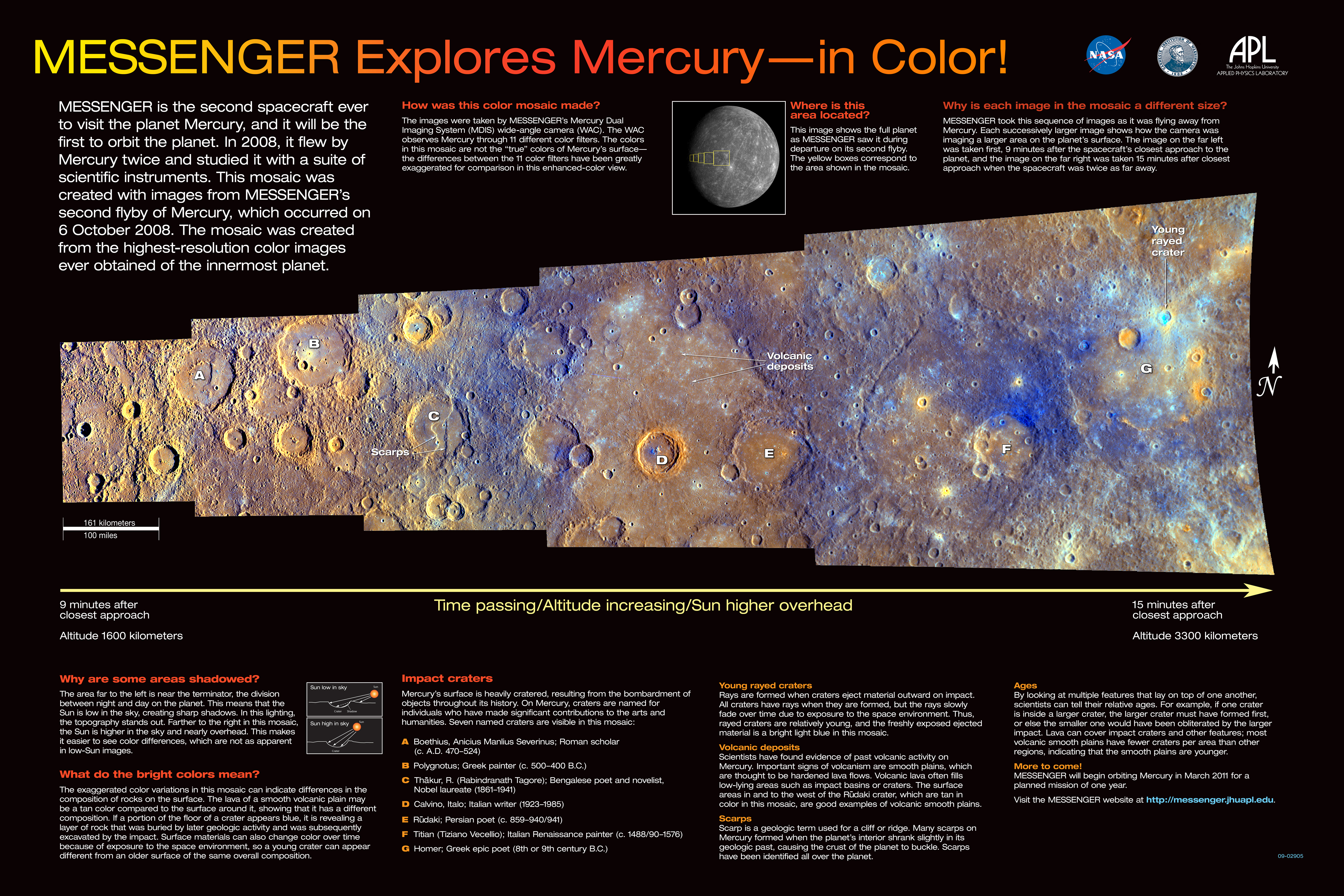
Mercury in Color


During MESSENGER's second flyby of Mercury, MDIS acquired a strip of high-resolution images obtained with each of the WAC's 11 different color filters. The graphic shown here displays the resulting enhanced-color mosaic and gives considerable detail about the images, how the mosaic was created, and the geologic features that can be seen.

Currently, these images are the highest-resolution color images ever obtained of the Solar System's innermost planet, but not for long! On March 18, 2011, MESSENGER will enter into orbit about Mercury, and the mission's extensive, year-long science observation campaign will begin. That campaign includes capturing color images of Mercury's surface at higher resolution than ever before.

Special thanks to Kathryn Powell, a summer intern student with the MESSENGER project, for contributing to the content of this graphic. Note: since the original creation of this graphic, the crater identified in the upper right with the label "young rayed crater" has been named Dominici. See PIA12871 to learn more about this recently named crater.

Date Acquired: October 6, 2008
Instrument: Wide Angle Camera (WAC) of the Mercury Dual Imaging System (MDIS)

Photo credit: NASA/Johns Hopkins University Applied Physics Laboratory/Carnegie Institution of Washington

Note: There is a very nice annotated poster of this image located here.

Wednesday, January 5, 2011

Mercury Landscape


When MESSENGER first flew by Mercury on January 14, 2008, MDIS acquired images of a large portion of Mercury's surface that had never previously been seen by spacecraft. This mosaic of NAC images shows some of the geologic features discovered during that first flyby that have been subsequently named: the curving cliff face of Beagle Rupes, the elongated crater Sveinsdottir, and the craters Izquierdo and Kunisada flooded with lava.

This year, the MESSENGER spacecraft is positioned once again to visit the Solar System's innermost planet. However, this time, the spacecraft won't just pass by. On March 18, 2011, a 15-minute maneuver will place MESSENGER in orbit about Mercury, making it the first spacecraft ever to do so. The MESSENGER mission will then begin an extensive year-long science campaign to unravel Mercury's mysteries. 2011 promises to be an exciting year of further discoveries for the MESSENGER mission.

Date Acquired: January 14, 2008
Instrument: Narrow Angle Camera (NAC) of the Mercury Dual Imaging System (MDIS)
Scale: Izquierdo Crater is 170 kilometers (106 miles) in diameter.


Photo credit: NASA/Johns Hopkins University Applied Physics Laboratory/Carnegie Institution of Washington

Thursday, December 23, 2010

Mercury 2010 Photo Compilation by Messenger


As 2010 comes to a close, the MESSENGER spacecraft is less than three months from becoming the first ever to enter orbit about Mercury. The coming year 2011 promises to be a historic one for the MESSENGER mission and for the exploration of the Solar System more generally. As we await turning the page on the calendar, let's look back at 12 image highlights from this year:

* January: Honoring Haitian Painter Benoit and American Photographer Lange
* February: Spectacular Color... with Better Yet to Come
* March: Rachmaninoff in Concert with Recently Named Craters on Mercury
* April: How Mercury's Copland Received Its Name
* May: Painting a Wave of Rays
* June: The Complex Geology of Geddes Crater
* July: Debussy and Its Hundreds of Miles of Rays
* August: Earth and Moon from 114 Million Miles
* September: Young Volcanism on Mercury
* October: Looking Toward Mercury's Horizon
* November: Mercury's Vast Expanses of Smooth Plains
* December: The Impressive Rays of Hokusai

Photo credit: NASA/Johns Hopkins University Applied Physics Laboratory/Carnegie Institution of Washington

Thursday, December 9, 2010

The Rays of Hokusai Crater


This mosaic of NAC images shows the impact crater Hokusai, located on Mercury at a latitude of 58° North. The crater has an impressive system of rays, which extend as much as a thousand kilometers (more than 600 miles) across the planet and are the longest that have yet been identified on Mercury.

Such rays are formed when an impact excavates material from beneath the surface and throws that material outward from the crater. These bright rays, consisting of both ejecta and secondary craters that form when the ejected material re-impacts the surface, slowly begin to fade as they are exposed to the harsh space environment. Mercury and other airless planetary bodies are being constantly bombarded with micrometeoroids and energetic ions, producing an effect known as space weathering. Craters with bright rays are thought to be relatively young because the rays are still visible, indicating that they have had less exposure to such weathering processes than craters that lack rays.

Although the extent of some of Hokusai's rays have been determined, images acquired during MESSENGER's three Mercury flybys have not yet shown all of Hokusai's rays. During MESSENGER's orbital observations, which will begin in March 2011, MDIS will acquire high-resolution color images of Mercury's entire surface. This global color map will allow the full extent of the extensive systems of rays emanating from Hokusai and other young craters to be mapped for the first time.

Date Acquired: October 6, 2008
Instrument: Narrow Angle Camera (NAC) of the Mercury Dual Imaging System (MDIS)
Scale: The diameter of Mercury is 4,880 kilometers (3030 miles). Hokusai has a diameter of 95 kilometers (59 miles)

Photo credit: NASA/Johns Hopkins University Applied Physics Laboratory/Carnegie Institution of Washington