Thursday, January 30, 2014

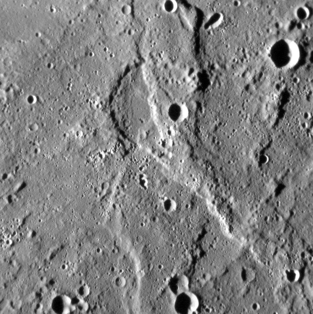
Xiao Zhao Crater


As anticipated in Monday's posting, MESSENGER has started to send back its two-month backlog of images. Included in the recently arrived batch is this triple take of Xiao Zhao. This image is very similar to this image from June 2012 and this image from December 2012; Xiao Zhao is one of the locations being repeatedly imaged to look for any slight hints of change.

This image was acquired as a high-resolution targeted observation. Targeted observations are images of a small area on Mercury's surface at resolutions much higher than the 200-meter/pixel morphology base map. It is not possible to cover all of Mercury's surface at this high resolution, but typically several areas of high scientific interest are imaged in this mode each week.

Date acquired: December 04, 2013
Image Mission Elapsed Time (MET): 28472584
Image ID: 5318200
Instrument: Narrow Angle Camera (NAC) of the Mercury Dual Imaging System (MDIS)
Center Latitude: 10.65°
Center Longitude: 123.94° E
Resolution: 34 meters/pixel
Scale: Xiao Zhao is 24 km (15 miles) in diameter
Incidence Angle: 24.9°
Emission Angle: 32.4°
Phase Angle: 44.7°

Photo credit: NASA/Johns Hopkins University Applied Physics Laboratory/Carnegie Institution of Washington

Tuesday, January 28, 2014

Impact Craters in Rasditladi Quadrant


If absence makes the heart grow fonder, then many on the MESSENGER team are now really fond of MDIS images! It has been over two months since the MESSENGER spacecraft returned images of Mercury's surface through routine downlink operations. Shown here is one of the last images sent before the two month gap. The lack of images is due to a very logical explanation: Mercury (and hence the MESSENGER spacecraft) has been on the opposite side of the Sun from the Earth, limiting the amount of data that can be downlinked. Generally, MDIS images take up more room than the data from MESSENGER's other instruments, so MDIS images are downlinked last, after all other instrument data are down. Happily, the distance between Mercury and the Earth is now decreasing; check out where both planets are today. Soon, we'll again have new images of Mercury's surface!

This image was acquired as part of MDIS's high-incidence-angle base map. The high-incidence-angle base map complements the surface morphology base map of MESSENGER's primary mission that was acquired under generally more moderate incidence angles. High incidence angles, achieved when the Sun is near the horizon, result in long shadows that accentuate the small-scale topography of geologic features. The high-incidence-angle base map was acquired with an average resolution of 200 meters/pixel.

Date acquired: November 20, 2013
Image Mission Elapsed Time (MET): 27234508
Image ID: 5230158
Instrument: Wide Angle Camera (WAC) of the Mercury Dual Imaging System (MDIS)
WAC filter: 7 (748 nanometers)
Center Latitude: 44.20°
Center Longitude: 223.3° E
Resolution: 150 meters/pixel
Scale: This image is roughly 280 km (170 miles) across
Incidence Angle: 60.6°
Emission Angle: 55.0°
Phase Angle: 30.0°

Photo credit: NASA/Johns Hopkins University Applied Physics Laboratory/Carnegie Institution of Washington

Note: This image is located near the center of Raditladi Quadrant; the closest named feature to this image is Nawahi Crater, which is some distance to the east.

Saturday, January 25, 2014

Tolstoj Basin and Nureyev Crater


The Tolstoj basin (355 km in diameter) can be seen at the bottom edge of the frame, its center filled with smooth plains and surrounded by a large region of low-reflectance ejecta. The fresh, bright-rayed crater Nureyev is visible near the limb.

This image was acquired as part of MDIS's limb imaging campaign. Once per week, MDIS captures images of Mercury's limb, with an emphasis on imaging the southern hemisphere limb. These limb images provide information about Mercury's shape and complement measurements of topography made by the Mercury Laser Altimeter (MLA) of Mercury's northern hemisphere.

Date acquired: November 21, 2013
Image Mission Elapsed Time (MET): 27346412
Image ID: 5238318
Instrument: Wide Angle Camera (WAC) of the Mercury Dual Imaging System (MDIS)
WAC filter: 7 (748 nanometers)
Center Latitude: -4.37°
Center Longitude: 188.8° E
Resolution: 1015 meters/pixel
Incidence Angle: 14.6°
Emission Angle: 58.8°
Phase Angle: 63.2°

Photo credit: NASA/Johns Hopkins University Applied Physics Laboratory/Carnegie Institution of Washington

Tuesday, January 21, 2014

To Ngoc Van Crater


Crater To Ngoc Van, named for a Vietnamese painter, is seen at the top of this image. The oblique angle provides a great view into the irregularly shaped pit within To Ngoc Van, which is thought to have formed via explosive volcanism and provides evidence for Mercury's geologically active past. Many of the smaller (5-10 km) craters in this scene were produced as secondary impacts from the ejecta of nearby Ahmad Baba crater. North is to the left in this image.

This image was acquired as part of MDIS's high-incidence-angle base map. The high-incidence-angle base map complements the surface morphology base map of MESSENGER's primary mission that was acquired under generally more moderate incidence angles. High incidence angles, achieved when the Sun is near the horizon, result in long shadows that accentuate the small-scale topography of geologic features. The high-incidence-angle base map was acquired with an average resolution of 200 meters/pixel.

Date acquired: November 19, 2013
Image Mission Elapsed Time (MET): 27148228
Image ID: 5223996
Instrument: Wide Angle Camera (WAC) of the Mercury Dual Imaging System (MDIS)
WAC filter: 7 (748 nanometers)
Center Latitude: 53.36°
Center Longitude: 239.6° E
Resolution: 154 meters/pixel
Scale: Crater To Ngoc Van is 71 km (44 miles) in diameter
Incidence Angle: 73.7°
Emission Angle: 65.6°
Phase Angle: 30.0°

Photo credit: NASA/Johns Hopkins University Applied Physics Laboratory/Carnegie Institution of Washington

Saturday, January 18, 2014

Double Crater


The surface of Mercury is dominated by the record of impact craters and basins that is has accrued over billions of years, and so it is no surprise that, occasionally, one impact crater forms within another. In this scene, the smaller crater in the bottom center of the image, some 16 km (10 miles) in diameter, is sited entirely within a larger crater, 40 km (25 miles) across. As we have seen often before, the Law of Superposition allows us to determine the sequence in which these craters formed -- the smaller one could not have survived the formation of the larger crater, and so formed second.

This image was acquired as a high-resolution targeted observation. Targeted observations are images of a small area on Mercury's surface at resolutions much higher than the 200-meter/pixel morphology base map. It is not possible to cover all of Mercury's surface at this high resolution, but typically several areas of high scientific interest are imaged in this mode each week.

Date acquired: November 11, 2013
Image Mission Elapsed Time (MET): 26454699
Image ID: 5174833
Instrument: Narrow Angle Camera (NAC) of the Mercury Dual Imaging System (MDIS)
Center Latitude: -26.32°
Center Longitude: 248.86° E
Resolution: 80 meters/pixel
Scale: The field of view in this image is about 90 km (56 mi.) across
Incidence Angle: 70.5°
Emission Angle: 4.4°
Phase Angle: 74.9°
North is to the top of the image.

Photo credit: NASA/Johns Hopkins University Applied Physics Laboratory/Carnegie Institution of Washington

Thursday, January 16, 2014

Terror Rupes


We have seen limb images of Mercury many times before, and they never fail to showcase the geological diversity (and splendor!) of the innermost planet. This time, something fills the scene with terror -- Terror Rupes, to be precise, the long, cliff-like landform visible at the center of the scene. Terror Rupes is one of Mercury's most prominent lobate scarps, and was named for HMS Terror, an eighteenth-century warship that later participated in scientific polar explorations. (For an explanation for how lobate scarps likely form, see this previous featured image.)

This image was acquired as part of MDIS's limb imaging campaign. Once per week, MDIS captures images of Mercury's limb, with an emphasis on imaging the southern hemisphere limb. These limb images provide information about Mercury's shape and complement measurements of topography made by the Mercury Laser Altimeter (MLA) of Mercury's northern hemisphere.

Date acquired: February 04, 2012
Image Mission Elapsed Time (MET): 236853865
Image ID: 1353252
Instrument: Wide Angle Camera (WAC) of the Mercury Dual Imaging System (MDIS)
WAC filter: 7 (748 nanometers)
Center Latitude: -69.3°
Center Longitude: 96.0° E
Resolution: 2.7 kilometers/pixel
Incidence Angle: 80.3°
Emission Angle: 50.9°
Phase Angle: 114.5°

Image credit: NASA/Johns Hopkins University Applied Physics Laboratory/Carnegie Institution of Washington

Tuesday, January 14, 2014

Lobate Scarp in Rembrandt Basin


The Rembrandt basin is the second-largest well preserved impact structure on Mercury, and is one of the best examples of a process that has irrevocably shaped the surface of the innermost planet. Yet the planet has been fundamentally shaped by another process -- global contraction -- that has resulted in the formation of lobate scarps and wrinkle ridges across the surface of Mercury.

In this image, we see a good example of where these processes meet. The most prominent landform in the scene is a north-west-trending scarp, its eastern margin illuminated by the Sun. Scarps such as this form when one portion of Mercury's crust thrusts up over another, the result of crustal shortening in response to the planet's volume decreasing as its interior cools. Yet if you look carefully, you might spy an alignment in the texture of the surface here, trending from the bottom-left to the top-right of the image. This alignment is due to radial scouring of the surface around Rembrandt by debris thrown out during the impact that formed the basin.

This image was acquired as a high-resolution targeted observation. Targeted observations are images of a small area on Mercury's surface at resolutions much higher than the 200-meter/pixel morphology base map. It is not possible to cover all of Mercury's surface at this high resolution, but typically several areas of high scientific interest are imaged in this mode each week.

Date acquired: November 5, 2013
Image Mission Elapsed Time (MET): 25999800
Image ID: 5142079
Instrument: Narrow Angle Camera (NAC) of the Mercury Dual Imaging System (MDIS)
Center Latitude: -20.99°
Center Longitude: 100.55° E
Resolution: 115 meters/pixel
Scale: The field of view in this image is about 120 km (75 mi.) across
Incidence Angle: 79.4°
Emission Angle: 12.2°
Phase Angle: 67.2°
North is to the bottom of the image.

Image credit: NASA/Johns Hopkins University Applied Physics Laboratory/Carnegie Institution of Washington
Saturday, January 11, 2014

Impact Crater with Pit Crater


The impact crater at the top center of this image is characterized by a sharp rim and high-reflectance ejecta. Lobes of slumped material are found where the wall meets the floor. The central peak is notable because it contains a pit. A recent survey1 found 27 central pit craters on Mercury. All of these central pit craters are located in plains units, but the mechanism by which the pits form is uncertain.

1 Z. Xiao and G. Komatsu (2013), Impact craters with ejecta flows and central pits on Mercury, Planetary and Space Science, vol. 82-83, pp. 62-78.

This image was acquired as part of MDIS's high-resolution surface morphology base map. The surface morphology base map covers more than 99% of Mercury's surface with an average resolution of 200 meters/pixel. Images acquired for the surface morphology base map typically are obtained at off-vertical Sun angles (i.e., high incidence angles) and have visible shadows so as to reveal clearly the topographic form of geologic features.

Date acquired: July 17, 2011
Image Mission Elapsed Time (MET): 219350124
Image ID: 513704
Instrument: Narrow Angle Camera (NAC) of the Mercury Dual Imaging System (MDIS)
Center Latitude: 19.42°
Center Longitude: 63.27° E
Resolution: 143 meters/pixel
Scale: The impact crater of interest is about 17 km (11 mi.) in diameter
Incidence Angle: 59.8°
Emission Angle: 12.8°
Phase Angle: 47.0°

Image credit: NASA/Johns Hopkins University Applied Physics Laboratory/Carnegie Institution of Washington

Thursday, January 9, 2014

Giambologna Crater


This lovely, fresh, complex crater with a crescent-shaped central peak was recently given the name Giambologna by the International Astronomical Union. The Dutch sculptor Jean Boulogne Giambologna (1529-1608) is most famous for his bronze statues of the god Mercury. The inset photograph shows one that resides in the Museo Nazionale del Bargello, Florence, Italy. Giambologna crater is distinctive for its wide, terraced western wall and the very smooth impact melt pond that covers the eastern floor. The wall terracing probably resulted from extensive collapse that happened because Giambologna formed on a slope -- the wall of an older, larger crater.

This image was acquired as part of MDIS's high-resolution stereo imaging campaign. Images from the stereo imaging campaign are used in combination with the surface morphology base map or the albedo base map to create high-resolution stereo views of Mercury's surface, with an average resolution of 200 meters/pixel. Viewing the surface under the same Sun illumination conditions but from two or more viewing angles enables information about the small-scale topography of Mercury's surface to be obtained.

Date acquired: October 15, 2011
Image Mission Elapsed Time (MET): 227171471
Image ID: 888364
Instrument: Narrow Angle Camera (NAC) of the Mercury Dual Imaging System (MDIS)
Center Latitude: -42.86°
Center Longitude: 236.7° E
Resolution: 202 meters/pixel
Scale: Giambologna crater is about 67 km (42 mi.) in diameter; Giambologna's Mercury is 180 cm (71 in.) tall
Incidence Angle: 65.8°
Emission Angle: 23.9°
Phase Angle: 67.8°

Image credit: NASA/Johns Hopkins University Applied Physics Laboratory/Carnegie Institution of Washington

Tuesday, January 7, 2014

Flow-Like Ejecta From an Unnamed Crater


The left side of today's image is dominated by an unnamed 75-km-diameter impact crater. The crater has several interesting features. Its western wall is quite broad, with extensive terracing and landslide scarps. The floor of the crater is flat, having been filled by volcanic plains or impact melt. The small central peaks, parts of the floor, and spots along the eastern rim are dotted with high-reflectance hollows. Finally, as outlined in the inset, the ejecta to the north and east of the rim appears to have flowed along the ground, and formed a terminal scarp. A recent paper by Beary Xiao and Goro Komatsu discusses this and other Mercurian craters that have flow-like ejecta, and makes comparisons with similar landforms on the Moon and Mars.

Z. Xiao and G. Komatsu (2013), Impact craters with ejecta flows and central pits on Mercury, Planetary and Space Science, vol. 82-83, pp. 62-78.

This image was acquired as part of MDIS's high-resolution stereo imaging campaign. Images from the stereo imaging campaign are used in combination with the surface morphology base map or the albedo base map to create high-resolution stereo views of Mercury's surface, with an average resolution of 200 meters/pixel. Viewing the surface under the same Sun illumination conditions but from two or more viewing angles enables information about the small-scale topography of Mercury's surface to be obtained.

Date acquired: November 03, 2011
Image Mission Elapsed Time (MET): 228803487
Image ID: 966206
Instrument: Wide Angle Camera (WAC) of the Mercury Dual Imaging System (MDIS)
WAC filter: 7 (748 nanometers)
Center Latitude: 13.45°
Center Longitude: 298.0° E
Resolution: 182 meters/pixel
Scale: The scene is about 190 km (118 mi.) across
Incidence Angle: 68.6°
Emission Angle: 15.5°
Phase Angle: 55.3°
North is up in this image.

Image credit: NASA/Johns Hopkins University Applied Physics Laboratory/Carnegie Institution of Washington

Wednesday, January 1, 2014

Messenger's 2013 Year in Review


The year 2013 has been another year of operations and discoveries for MESSENGER, finally including 100% image coverage of the planet by the Mercury Dual Imaging System (MDIS)! As another year draws to a close, we look back at some of the featured images from the year, and look forward to continued operations, including some of the highest-resolution images ever taken of Mercury, in 2014!

January: They Call Me Muddy Waters
February: Colors of the Innermost Planet
March: A Colorful Group
April: An Unnamed Wonder
May: 100% Coverage
June: It's a Sublimation Formation!
July: Digital Elevation Model of Mercury's Northern Hemisphere
August: Peek-a-boo!
September: A Volcanic View
October: Degas' Impression
November: A Late Holloween
December: On the Horizon

You can also revisit previous yearly compilations from 2008, 2009, 2010, 2011, and 2012.

Image credit: NASA/Johns Hopkins University Applied Physics Laboratory/Carnegie Institution of Washington

Tuesday, December 31, 2013

Hilly Terrain NW of Angkor Vallis


With the Sun low on the horizon, shadows accentuate the hilly nature of this terrain. This surface has been battered by repeated impacts for billions of years, creating the hilly surface that exists today. As a previous featured image of a nearby area put it, Mercury has been a "planetary punching bag."

This image was acquired as a high-resolution targeted observation. Targeted observations are images of a small area on Mercury's surface at resolutions much higher than the 200-meter/pixel morphology base map. It is not possible to cover all of Mercury's surface at this high resolution, but typically several areas of high scientific interest are imaged in this mode each week.

Date acquired: November 12, 2013
Image Mission Elapsed Time (MET): 26543484
Image ID: 5181047
Instrument: Narrow Angle Camera (NAC) of the Mercury Dual Imaging System (MDIS)
Center Latitude: 67.11°
Center Longitude: 249.8° E
Resolution: 11 meters/pixel
Scale: This image is 14.6 kilometers (9.1 miles) across
Incidence Angle: 82.0°
Emission Angle: 36.9°
Phase Angle: 118.9°

Photo credit: NASA/Johns Hopkins University Applied Physics Laboratory/Carnegie Institution of Washington

Note: This image is located northwest of Angkor Vallis in the Raditladi Quadrangle.

Thursday, December 19, 2013

Damer Crater


The steep walls of the crater Damer are highlighted in today's image. Named for the English sculptor Anne Seymour Damer (1749-1828) earlier this year, the 60-kilometer-diameter crater is distinguished by a central peak covered with hollows.

This image was acquired as a high-resolution targeted observation. Targeted observations are images of a small area on Mercury's surface at resolutions much higher than the 200-meter/pixel morphology base map. It is not possible to cover all of Mercury's surface at this high resolution, but typically several areas of high scientific interest are imaged in this mode each week.

Date acquired: November 13, 2013
Image Mission Elapsed Time (MET): 26687033
Image ID: 5191249
Instrument: Narrow Angle Camera (NAC) of the Mercury Dual Imaging System (MDIS)
Center Latitude: 36.25°
Center Longitude: 243.4° E
Resolution: 17 meters/pixel
Scale: This image is 17 kilometers (11 miles) across
Incidence Angle: 68.3°
Emission Angle: 3.0°
Phase Angle: 65.3°

Photo credit: NASA/Johns Hopkins University Applied Physics Laboratory/Carnegie Institution of Washington

Tuesday, December 17, 2013

Wang Meng, Judah Ha Levi and Glinka Craters


Three named craters are featured prominently in this view. The peak-ring basin Wang Meng is toward the horizon, while the pit-floor crater Glinka is near the bottom left. Judah Ha Levi is about half way in between the two.

This image was acquired as part of MDIS's high-incidence-angle base map. The high-incidence-angle base map complements the surface morphology base map of MESSENGER's primary mission that was acquired under generally more moderate incidence angles. High incidence angles, achieved when the Sun is near the horizon, result in long shadows that accentuate the small-scale topography of geologic features. The high-incidence-angle base map was acquired with an average resolution of 200 meters/pixel.

Date acquired: November 16, 2013
Image Mission Elapsed Time (MET): 26888421
Image ID: 5205547
Instrument: Wide Angle Camera (WAC) of the Mercury Dual Imaging System (MDIS)
WAC filter: 7 (748 nanometers)
Center Latitude: 10.04°
Center Longitude: 251.2° E
Resolution: 292 meters/pixel
Scale: Wang Meng has a diameter of 165 km (103 miles)

Photo credit: NASA/Johns Hopkins University Applied Physics Laboratory/Carnegie Institution of Washington

Saturday, December 14, 2013

Mena Crater


Here we get a closer look at the fresh, bright-rayed crater Mena. Solidified impact melt forms a smooth pond on the western side of the crater floor. This asymmetry is due to the fact that Mena formed on the sloping rim of an older crater, as seen in this wider view.

This image was acquired as a targeted set of stereo images. Targeted stereo observations are acquired at resolutions much higher than that of the 200-meter/pixel stereo base map. These targets acquired with the NAC enable the detailed topography of Mercury's surface to be determined for a local area of interest.

Date acquired: November 13, 2013
Image Mission Elapsed Time (MET): 26657614
Image ID: 5189176
Instrument: Narrow Angle Camera (NAC) of the Mercury Dual Imaging System (MDIS)
Center Latitude: -0.24°
Center Longitude: 235.3° E
Resolution: 37 meters/pixel
Scale: Mena crater has a diameter of 15 km (9 miles)
Incidence Angle: 54.7°
Emission Angle: 23.4°
Phase Angle: 71.0°

Photo credit: NASA/Johns Hopkins University Applied Physics Laboratory/Carnegie Institution of Washington

Thursday, December 12, 2013

Ghost Crater


Mercury's surface has been extensively modified by tectonic activity. Giant thrust faults are thought to be the result of global cooling and contraction of the planet, and Mercury's smooth plains in particular are folded and wrinkled. With the Sun very low in the sky, the complexity of tectonic features in the northern volcanic plains is especially apparent. The wrinkle-ridge ring (also known as a "ghost crater") on the eastern edge of the scene was also captured here (see PIA15636) at more moderate illumination angles.

This image was acquired as part of MDIS's high-incidence-angle base map. The high-incidence-angle base map complements the surface morphology base map of MESSENGER's primary mission that was acquired under generally more moderate incidence angles. High incidence angles, achieved when the Sun is near the horizon, result in long shadows that accentuate the small-scale topography of geologic features. The high-incidence-angle base map was acquired with an average resolution of 200 meters/pixel.

Date acquired: November 12, 2013
Image Mission Elapsed Time (MET): 26543953
Image ID: 5181050
Instrument: Wide Angle Camera (WAC) of the Mercury Dual Imaging System (MDIS)
WAC filter: 7 (748 nanometers)
Center Latitude: 80.04°
Center Longitude: 86.24° E
Resolution: 230 meters/pixel
Scale: Scene is 125 km (78 miles) from top to bottom
Incidence Angle: 90.7°
Emission Angle: 49.8°
Phase Angle: 140.6°

Photo credit: NASA/Johns Hopkins University Applied Physics Laboratory/Carnegie Institution of Washington

Saturday, December 7, 2013

Nureyev Crater


The bright, rayed crater Nureyev is at center stage in this dramatic view toward Mercury's eastern limb. The crater's namesake is the Soviet/British ballet dancer Rudolf Nureyev, who died in 1993. This set of color images was obtained at a relatively small phase angle and consequently is dominated by variations in the inherent reflectance and color of the surface. The shape of the crater can be better perceived in an image with a larger phase angle, allowing shadows and shading to reveal the topography of the surface.

This image was acquired as part of MDIS's high-resolution 3-color imaging campaign. The map produced from this campaign complements the 8-color base map (at an average resolution of 1 km/pixel) acquired during MESSENGER's primary mission by imaging Mercury's surface in a subset of the color filters at the highest resolution possible. The three narrow-band color filters are centered at wavelengths of 430 nm, 750 nm, and 1000 nm, and image resolutions generally range from 100 to 400 meters/pixel in the northern hemisphere.

Date acquired: June 17, 2012
Image Mission Elapsed Time (MET): 248431526, 248431518, 248431522
Image ID: 2033219, 2033217, 2033218
Instrument: Wide Angle Camera (WAC) of the Mercury Dual Imaging System (MDIS)
WAC filters: 9, 7, 6 (996, 748, 433 nanometers) in red, green, and blue
Center Latitude: 12.6°
Center Longitude: 187.0° E
Resolution: 660 meters/pixel
Scale: Nureyev crater is about 16 km (10 mi.) in diameter
Incidence Angle: 26.0°
Emission Angle: 54.1°
Phase Angle: 28.0°

Photo credit: NASA/Johns Hopkins University Applied Physics Laboratory/Carnegie Institution of Washington

Friday, December 6, 2013

Unnamed Craters


In the center of this image is a high-reflectance area that seems to be confined to a region of lower elevation that is bounded by linear scarp (cliff) segments. Such diffuse bright areas are sometimes related to the deposition of small secondary craters and ray segments by a relatively recent impact crater, but looking at regional images (for example, using QuickMap), there are no rayed craters in the immediate vicinity (though Han Kan might be a candidate). Therefore, a compositional difference may account for the difference in the albedo (brightness) of the material in the low-lying area. Are the scarps tectonic in nature (the result of vertical movement along faults), or were they formed by secondary crater chains? Also of interest in the scene are hollows on the central peak of the crater at the upper left, and the smooth impact melt on the floor of the terrace-walled crater just below center. Scientists will be at work for many years to solve the puzzle of Mercury's complicated geological history!

This image was acquired as part of the NAC ride-along imaging campaign. When data volume is available and MDIS is not acquiring images for its other campaigns, high-resolution NAC images are obtained of the surface. These images are designed not to interfere with other instrument observations but take full advantage of periods during the mission when extra data volume is available.

Date acquired: May 19, 2012
Image Mission Elapsed Time (MET): 245904903
Image ID: 1853014
Instrument: Narrow Angle Camera (NAC) of the Mercury Dual Imaging System (MDIS)
Center Latitude: -47.3°
Center Longitude: 177.3° E
Resolution: 179 meters/pixel
Scale: The scene is about 184 km (114 mi.) across
Incidence Angle: 47.7°
Emission Angle: 24.2°
Phase Angle: 71.9°

Photo credit: NASA/Johns Hopkins University Applied Physics Laboratory/Carnegie Institution of Washington

Tuesday, December 3, 2013

Bright Impact Crater Deposits Near Matisse Crater


This image brings us back to the vicinity of Matisse, the subject of several recent Gallery images. The unnamed impact crater with the bright pyroclastic deposit on its southern floor also has two arcuate scallops on its northern wall. These were the sites of massive landslides that took place when the oversteepened crater wall collapsed. The ultimate cause of the collapse is the topography of the area where the crater formed: the northern part of the crater formed on the wall of Matisse.

This image was acquired as part of MDIS's high-resolution albedo base map. The best images for discerning variations in albedo, or brightness, on the surface are acquired when the Sun is overhead, so these images typically are taken at low incidence angles. The albedo base map covers Mercury's surface at an average resolution of 200 meters/pixel.

Date acquired: April 05, 2012
Image Mission Elapsed Time (MET): 242124773
Image ID: 1609270
Instrument: Narrow Angle Camera (NAC) of the Mercury Dual Imaging System (MDIS)
Center Latitude: -22.85°
Center Longitude: 267.3° E
Resolution: 196 meters/pixel
Scale: The crater with the bright floor is about 70 km (44 mi.) in diameter
Incidence Angle: 40.8°
Emission Angle: 30.0°
Phase Angle: 70.8°

Photo credit: NASA/Johns Hopkins University Applied Physics Laboratory/Carnegie Institution of Washington

Saturday, November 30, 2013

Lobate Scarp North of Mussorgskij Crater


In contrast to a previous image, not all lobate scarps are large. The example pictured here is much smaller -- both in terms of length and relief -- than Discovery Rupes, but it too has contributed to the shortening of Mercury's crust. This scarp cross-cuts an unnamed, 65-km-diameter crater, which is filled with smooth plains, just north of Mussorgskij crater. Whether this scarp is younger than Discovery Rupes and so has not had as much time to accumulate tectonic deformation, or if instead it did not shorten the crust as much for other reasons, remains as yet unclear.

This image was acquired as a high-resolution targeted observation. Targeted observations are images of a small area on Mercury's surface at resolutions much higher than the 200-meter/pixel morphology base map. It is not possible to cover all of Mercury's surface at this high resolution, but typically several areas of high scientific interest are imaged in this mode each week.

Date acquired: September 11, 2013
Image Mission Elapsed Time (MET): 21213842
Image ID: 4802121
Instrument: Narrow Angle Camera (NAC) of the Mercury Dual Imaging System (MDIS)
Center Latitude: 35.4°
Center Longitude: 262.0° E
Resolution: 24.1 meters/pixel
Scale: The field of view in this image is about 29 km (18 mi.) from left to right
Incidence Angle: 60.59°
Emission Angle: 31.91°
Phase Angle: 28.68°
North is to the bottom of the image.

Photo credit: NASA/Johns Hopkins University Applied Physics Laboratory/Carnegie Institution of Washington