skip to main |
skip to sidebar

Today's image is located on the western edge of the Rembrandt basin. A scarp cuts right through a pair of older impact craters, leaving them deformed. This image is an anaglyph, which creates a 3D effect when viewed through a pair of red-cyan glass. If you've found a pair of glasses, check out these other 3D views created with MESSENGER images.
This image was acquired as a targeted set of stereo images. Targeted stereo observations are acquired at resolutions much higher than that of the 200-meter/pixel stereo base map. These targets acquired with the NAC enable the detailed topography of Mercury's surface to be determined for a local area of interest.
Date acquired: August 13, 2013
Image Mission Elapsed Time (MET): 18733660, 18734492
Image ID: 4625953, 4625956
Instrument: Narrow Angle Camera (NAC) of the Mercury Dual Imaging System (MDIS)
Center Latitude: -37.6°
Center Longitude: 79.15° E
Resolution: 100 meters/pixel
Scale: This image is roughly 90 kilometers across (56 miles)
Incidence Angle: 81.0°, 81.0°
Emission Angle: 0.3°, 19.9°
Phase Angle: 81.2°, 81.9°
Orientation: North is to the right to enhance the 3D effect.
Image credit: NASA/Johns Hopkins University Applied Physics Laboratory/Carnegie Institution of Washington
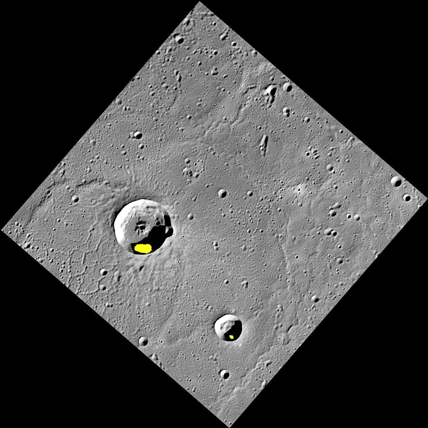
Finding evidence for water ice on the planet closest to the Sun was an exciting discovery, but there is still more to learn about Mercury's icy deposits. Regions of permanent shadow seem to be a requirement for water ice to reside on the Solar System's innermost planet, so the large majority of Mercury's water ice deposits are located within impact craters at high latitudes. The two craters shown here, Egonu and Monk, both appear to have areas of permanent shadow and radar-bright deposits (shown in yellow) that are associated with water ice. However these craters are located a fair distance from Mercury's pole, all the way down at 66° latitude! How long can ice stay in these craters? That is just one of the interesting questions about Mercury's water ice deposits still being investigated.
This image was acquired as part of MDIS's high-resolution surface morphology base map. The surface morphology base map covers more than 99% of Mercury's surface with an average resolution of 200 meters/pixel. Images acquired for the surface morphology base map typically are obtained at off-vertical Sun angles (i.e., high incidence angles) and have visible shadows so as to reveal clearly the topographic form of geologic features.
Date acquired: July 20, 2011
Image Mission Elapsed Time (MET): 219648898
Image ID: 528063
Instrument: Wide Angle Camera (WAC) of the Mercury Dual Imaging System (MDIS)
WAC filter: 7 (748 nanometers)
Center Latitude: 67.29°
Center Longitude: 63.51° E
Resolution: 133 meters/pixel
Scale: Egonu has a diameter of 25 km (16 miles); Monk has a diameter of 13 km (8 miles)
Incidence Angle: 74.5°
Emission Angle: 0.2°
Phase Angle: 74.5°
Arecibo Radar Image: Shown in yellow, from Harmon et al., Icarus, 211, 37-50 (2011)
Image credit: NASA/Johns Hopkins University Applied Physics Laboratory/Carnegie Institution of Washington

Ever since MESSENGER entered orbit about Mercury in 2011, the dark impact melt flow of Waters crater has been a feature of interest. Targeted color imaging showed the distinctive blue color of the impact melt flow, inspiring the crater to be named for blues legend Muddy Waters in 2012. In 2013, this high-resolution image was acquired, revealing stunning new details of the impact melt flow beyond those visible previously.
This image was acquired as a targeted set of stereo images. Targeted stereo observations are acquired at resolutions much higher than that of the 200-meter/pixel stereo base map. These targets acquired with the NAC enable the detailed topography of Mercury's surface to be determined for a local area of interest.
Date acquired: September 16, 2013
Image Mission Elapsed Time (MET): 21673915
Image ID: 4834878
Instrument: Narrow Angle Camera (NAC) of the Mercury Dual Imaging System (MDIS)
Center Latitude: -9.00°
Center Longitude: 254.7° E
Resolution: 56 meters/pixel
Scale: Waters crater is 15 kilometers (9 miles) in diameter
Incidence Angle: 44.0°
Emission Angle: 44.8°
Phase Angle: 85.5°
Photo credit: NASA/Johns Hopkins University Applied Physics Laboratory/Carnegie Institution of Washington

Today's image is an anaglyph, which means if you have a pair of red-cyan glasses, you can see the image in 3D. While this peak, which is slightly over a kilometer tall, is located within a circular depression, it is much larger relative to the size of the depression than other central peaks that formed during impact cratering events on Mercury. Additionally, the feature has a distinctive red color signature, associated with sites of explosive volcanic eruptions on Mercury. Peaks such as this one are rare on Mercury, but there is a similar one nearby that also shares the same red color characteristics.
This image was acquired as a targeted set of stereo images. Targeted stereo observations are acquired at resolutions much higher than that of the 200-meter/pixel stereo base map. These targets acquired with the NAC enable the detailed topography of Mercury's surface to be determined for a local area of interest.
Date acquired: November 14, 2013
Image Mission Elapsed Time (MET): 26772351, 26772627
Image ID: 5197359, 5197360
Instrument: Narrow Angle Camera (NAC) of the Mercury Dual Imaging System (MDIS)
Center Latitude: -8.50°
Center Longitude: 224.4° E
Resolution: 50 meters/pixel
Scale: This image is roughly 45 km (28 miles) across
Incidence Angle: 44.7°, 44.6°
Emission Angle: 14.2°, 24.6°
Phase Angle: 59.0°, 62.2°
Orientation: North is to the right, to enhance the 3D effect.
Image credit: NASA/Johns Hopkins University Applied Physics Laboratory/Carnegie Institution of Washington

The peak-ring basin Scarlatti is seen at the center of this image. While Scarlatti has a typical peak ring in many respects, in the northeast section it transitions to a large (approximately 30 km) pit surrounded by high-reflectance material. This pit may be the site of past explosive volcanic activity.
This image was acquired as a targeted 11-color image set. Acquiring 11-color targets is a new campaign that began in March 2013 and that utilizes all of the WAC's 11 narrow-band color filters. Because of the large data volume involved, only features of special scientific interest are targeted for imaging in all 11 colors.
Date acquired: March 30, 2014
Image Mission Elapsed Time (MET): 38528557, 38528553, 38528551
Image ID: 6032934, 6032932, 6032931
Instrument: Wide Angle Camera (WAC) of the Mercury Dual Imaging System (MDIS)
WAC filters: 9, 7, 6 (996, 748, 433 nanometers) in red, green, and blue
Center Latitude: 40.7°
Center Longitude: 258.9° E
Scale: Scarlatti basin is 132 km (82 miles) in diameter
Image credit: NASA/Johns Hopkins University Applied Physics Laboratory/Carnegie Institution of Washington

A large (180-km diameter) crater occupies the scene, but it has been almost completely buried by the volcanic plains that make up the northern smooth plains. The rim of the buried crater, especially in the southeast, has helped to localize compressional deformation, leading to a wrinkle-ridge ring. The center is criss-crossed by extensional graben.
These images were acquired as part of MDIS's high-incidence-angle base map. The high-incidence-angle base map complements the surface morphology base map of MESSENGER's primary mission that was acquired under generally more moderate incidence angles. High incidence angles, achieved when the Sun is near the horizon, result in long shadows that accentuate the small-scale topography of geologic features. The high-incidence-angle base map was acquired with an average resolution of 200 meters/pixel.
Date acquired: March 09, 2014
Image Mission Elapsed Time (MET): 36713179, 36713230
Image ID: 5903920, 5903921
Instrument: Wide Angle Camera (WAC) of the Mercury Dual Imaging System (MDIS)
WAC filter: 7 (748 nanometers)
Center Latitude: 64.4°
Center Longitude: 23.8° E
Resolution: 258 meters/pixel
Scale: The buried basin is approximately 180 km (112 miles) across
Incidence Angle: 86.2°
Emission Angle: 51.1°
Phase Angle: 137.3°
Photo credit: NASA/Johns Hopkins University Applied Physics Laboratory/Carnegie Institution of Washington

Viewing a section of the southern crater in this pair, here we see the jumbled and cracked material on the crater's floor and smooth regions buried by impact melt. Little rock-bergs, tens to hundreds of meters across, dot the floor and are surrounded by a frozen sea of once-molten rock. The Sun is shining from the right.
This image was acquired as a high-resolution targeted observation. Targeted observations are images of a small area on Mercury's surface at resolutions much higher than the 200-meter/pixel morphology base map. It is not possible to cover all of Mercury's surface at this high resolution, but typically several areas of high scientific interest are imaged in this mode each week.
Date acquired: March 10, 2014
Image Mission Elapsed Time (MET): 36770146
Image ID: 5908043
Instrument: Narrow Angle Camera (NAC) of the Mercury Dual Imaging System (MDIS)
Center Latitude: 64.86°
Center Longitude: 255.3° E
Resolution: 12 meters/pixel
Scale: This scene is approximately 6 km (4 miles) across
Incidence Angle: 73.0°
Emission Angle: 5.8°
Phase Angle: 78.9°
Photo credit: NASA/Johns Hopkins University Applied Physics Laboratory/Carnegie Institution of Washington

Most meteorites are pieces of asteroids. About 130 meteorites have been linked to an origin on the planet Mars, and nearly 200 meteorites originated on the Moon. No meteorite has been convincingly shown to have come from Mercury. Impact cratering events on Mercury may blast material off the surface, but it is much more difficult for such material to move into an orbit that could intersect the orbit of Earth, compared with material derived from the Moon or Mars. In 1992, Stan Love and Klaus Keil published a study describing the likely characteristics of a Mercurian meteorite. A recent re-look at the topic of meteorites from Mercury, by Will Vaughan and Jim Head, pointed out that the dynamics of ejection are such that the most likely locations for source craters on Mercury are in regions centered on 90° and 270° E longitude.
Fonteyn crater, shown in today's gallery image, is a fresh 29-km diameter impact structure centered at about 33° N and 95° E, within the probable zone noted by Vaughan and Head. Fonteyn has a somewhat asymmetrical pattern of bright rays, suggesting that it formed in an oblique impact, which may favor ejection of material at speeds greater than escape velocity. Could the Fonteyn impact have launched material that has fallen on Earth, or is on its way?
This mosaic is a portion of MDIS's high-resolution surface morphology base map. The surface morphology base map covers more than 99% of Mercury's surface with an average resolution of 200 meters/pixel. Images acquired for the surface morphology base map typically are obtained at off-vertical Sun angles (i.e., high incidence angles) and have visible shadows so as to reveal clearly the topographic form of geologic features.
Image: This is a portion of the MDIS monochrome base map mosaic.
Instrument: Wide Angle Camera (WAC) of the Mercury Dual Imaging System (MDIS)
WAC filter: 7 (748 nanometers)
Scale: The scene is about 730 km (450 mi.) wide.
Photo credit: NASA/Johns Hopkins University Applied Physics Laboratory/Carnegie Institution of Washington

Presented here is a fine view of the 75-km diameter crater Rimbaud. Arthur Rimbaud was a French poet who lived from 1854 to 1891. He had a stormy relationship with Paul Verlaine, a symbolist poet. In Brussels in 1873, Verlaine shot Rimbaud, wounding him in the wrist. No crater named Verlaine exists on Mercury. A Verlaine crater on Mars was named for a town in France. Crossing the eastern floor and wall of Rimbaud from south to north is a ray from crater Han Kan.
This image was acquired as a targeted set of stereo images. Targeted stereo observations are acquired at resolutions much higher than that of the 200-meter/pixel stereo base map. These targets acquired with the NAC enable the detailed topography of Mercury's surface to be determined for a local area of interest.
Date acquired: November 12, 2013
Image Mission Elapsed Time (MET): 26596630
Image ID: 5185060
Instrument: Narrow Angle Camera (NAC) of the Mercury Dual Imaging System (MDIS)
Center Latitude: -63.38°
Center Longitude: 211.7° E
Resolution: 147 meters/pixel
Scale: Rimbaud crater is about 75 km (46.5 mi.) across.
Incidence Angle: 67.4°
Emission Angle: 22.9°
Phase Angle: 71.8°
Photo credit: NASA/Johns Hopkins University Applied Physics Laboratory/Carnegie Institution of Washington

The name Kuniyoshi was recently adopted by the International Astronomical Union for the 26.5 km diameter crater near the center of today's image. Utagawa Kuniyoshi was a Japanese painter and printmaker (1798-1861). The subjects of his artwork included landscapes, Kabuki scenes, cats, samurai heroes, and the mythical and supernatural. Kuniyoshi crater is morphologically fresh, with a sharp rim, steep central peak, and impact melt ponds on the floor and near-rim ejecta. To the west of Kuniyoshi is a famous Mercurian lobate scarp, Discovery Rupes.
This image was acquired as part of MDIS's high-resolution surface morphology base map. The surface morphology base map covers more than 99% of Mercury's surface with an average resolution of 200 meters/pixel. Images acquired for the surface morphology base map typically are obtained at off-vertical Sun angles (i.e., high incidence angles) and have visible shadows so as to reveal clearly the topographic form of geologic features.
Date acquired: February 25, 2012
Image Mission Elapsed Time (MET): 238701357
Image ID: 1441474
Instrument: Narrow Angle Camera (NAC) of the Mercury Dual Imaging System (MDIS)
Center Latitude: -57.65°
Center Longitude: 321.8° E
Resolution: 173 meters/pixel
Scale: The edges of the image are about 170 km (105 mi.) long.
Incidence Angle: 65.0°
Emission Angle: 0.7°
Phase Angle: 65.2°
Photo credit: NASA/Johns Hopkins University Applied Physics Laboratory/Carnegie Institution of Washington

The crater shown here, Boëthius, is 115 km (71 miles) in diameter. We have seen Boëthius before, when it was imaged by MESSENGER during its second flyby. Named for the early sixth-century Roman philosopher, Boethius has been filled with smooth plains that may be volcanic in origin. After that infilling, compressional stresses that are pervasive across the entire planet's surface resulted in the formation of the prominent lobate scarp that runs from top to bottom in the image. Boethius is yet another example of the Law of Superposition, which helps scientists to determine the sequence of events at any given location on Mercury.
This image was acquired as a high-resolution targeted observation. Targeted observations are images of a small area on Mercury's surface at resolutions much higher than the 200-meter/pixel morphology base map. It is not possible to cover all of Mercury's surface at this high resolution, but typically several areas of high scientific interest are imaged in this mode each week.
Date acquired: February 1, 2014
Image Mission Elapsed Time (MET): 33546022
Image ID: 5678647
Instrument: Narrow Angle Camera (NAC) of the Mercury Dual Imaging System (MDIS)
Center Latitude: 0.91° S
Center Longitude: 286.88° E
Resolution: 76 meters/pixel
Scale: The scene is 75 km (47 mi.) across
Incidence Angle: 72.8°
Emission Angle: 6.2°
Phase Angle: 66.6°
North is to the bottom in this image
Photo credit: NASA/Johns Hopkins University Applied Physics Laboratory/Carnegie Institution of Washington

In this dramatic image, Dominici crater takes center-stage. Dominici is 20 km (12 mi.) in diameter, and hosts a variety of landforms including a sharp crater rim, internal slumps, and abundant hollows. Dominici is also a rayed crater, which, together with its well-preserved rim, indicate that the crater is relatively young. This scene, taken from an oblique angle, gives us a good idea of what the surface of Mercury might look like from a spacecraft window as we zoom overhead!
This image was acquired as a high-resolution targeted observation. Targeted observations are images of a small area on Mercury's surface at resolutions much higher than the 200-meter/pixel morphology base map. It is not possible to cover all of Mercury's surface at this high resolution, but typically several areas of high scientific interest are imaged in this mode each week.
Date acquired: January 30, 2014
Image Mission Elapsed Time (MET): 33401837
Image ID: 5668405
Instrument: Narrow Angle Camera (NAC) of the Mercury Dual Imaging System (MDIS)
Center Latitude: 1.1° N
Center Longitude: 323.5° E
Resolution: 79 meters/pixel
Scale: The crater in the image center is 20 km (about 12 mi.) across
Incidence Angle: 36.2°
Emission Angle: 41.8°
Phase Angle: 77.4°
North is to the bottom in this image
Photo credit: NASA/Johns Hopkins University Applied Physics Laboratory/Carnegie Institution of Washington

Like Friday's image, today we see Mercury's surface at an image resolution we have rarely come close to before. In this scene, a portion of the rim of an unnamed crater 17 km (11 mi.) in diameter is visible, atop which sits a smaller, later crater (lower center). The prolonged record of impact cratering on Mercury is one of the planet's most visible traits, yet we continue to see the results of that process with ever higher-resolution images. And so, even at resolutions of 9 meters (~30 feet) per pixel, we observe small primary and secondary craters peppering the surface of the innermost planet.
This image was acquired as a high-resolution targeted observation. Targeted observations are images of a small area on Mercury's surface at resolutions much higher than the 200-meter/pixel morphology base map. It is not possible to cover all of Mercury's surface at this high resolution, but typically several areas of high scientific interest are imaged in this mode each week.
Date acquired: March 1, 2014
Image Mission Elapsed Time (MET): 35963392
Image ID: 5850686
Instrument: Narrow Angle Camera (NAC) of the Mercury Dual Imaging System (MDIS)
Center Latitude: 55.89°
Center Longitude: 303.66° E
Resolution: 9 meters/pixel
Scale: The crater in the lower center of the image is approximately 1.8 km (1.1 mi.) across
Incidence Angle: 59.9°
Emission Angle: 27.4°
Phase Angle: 32.5°
North is to the right in this scene.
Photo credit: NASA/Johns Hopkins University Applied Physics Laboratory/Carnegie Institution of Washington

This high-resolution image shows the intersection of two crater rims. The full craters can be seen in this context image -- the high-resolution image covers the rim intersection very close to the context image center. Downslope movement of material in the crater wall has exposed fresh, brighter soil.
This image was acquired as a high-resolution targeted observation. Targeted observations are images of a small area on Mercury's surface at resolutions much higher than the 200-meter/pixel morphology base map. It is not possible to cover all of Mercury's surface at this high resolution, but typically several areas of high scientific interest are imaged in this mode each week.
Date acquired: March 10, 2014
Image Mission Elapsed Time (MET): 36770148
Image ID: 5908044
Instrument: Narrow Angle Camera (NAC) of the Mercury Dual Imaging System (MDIS)
Center Latitude: 65.02°
Center Longitude: 255.4° E
Resolution: 12 meters/pixel
Scale: This image is approximately 8.8 km (5.5 mi.) across.
Incidence Angle: 73.1°
Emission Angle: 5.8°
Phase Angle: 78.9°
Photo credit: NASA/Johns Hopkins University Applied Physics Laboratory/Carnegie Institution of Washington

These two relatively fresh craters, ~34 km (21 miles) and ~20 km (12 miles) across, share a rim and both contain slumped material. Did they form during the same event, by two impactors? Did the rim of the large, highly degraded crater on the right side of the image influence the structure of the shared rim? Higher-resolution images taken during MESSENGER's final year of operations may help to elucidate their origin.
This image was acquired as part of MDIS's high-resolution stereo imaging campaign. Images from the stereo imaging campaign are used in combination with the surface morphology base map or the albedo base map to create high-resolution stereo views of Mercury's surface, with an average resolution of 200 meters/pixel. Viewing the surface under the same Sun illumination conditions but from two or more viewing angles enables information about the small-scale topography of Mercury's surface to be obtained.
Date acquired: October 12, 2011
Image Mission Elapsed Time (MET): 226922649
Image ID: 876240
Instrument: Wide Angle Camera (WAC) of the Mercury Dual Imaging System (MDIS)
WAC filter: 7 (748 nanometers)
Center Latitude: 64.76°
Center Longitude: 255.5° E
Resolution: 269 meters/pixel
Scale: The large crater at the image center is approximately 34 km (21 mi.) across.
Incidence Angle: 72.9°
Emission Angle: 14.3°
Phase Angle: 60.6°
Photo credit: NASA/Johns Hopkins University Applied Physics Laboratory/Carnegie Institution of Washington

This stunning image shows a portion of the sharp rim of an unnamed, ~28 km (17 mile) diameter complex crater. The upper right portion of the image lies outside of the crater, and the lower left portion of the image lies on the crater floor. The crater at the center of the image lies on the crater wall. North is to the right.
This image was acquired as a high-resolution targeted observation. Targeted observations are images of a small area on Mercury's surface at resolutions much higher than the 200-meter/pixel morphology base map. It is not possible to cover all of Mercury's surface at this high resolution, but typically several areas of high scientific interest are imaged in this mode each week.
Date acquired: March 14, 2014
Image Mission Elapsed Time (MET): 37087259
Image ID: 5930668
Instrument: Narrow Angle Camera (NAC) of the Mercury Dual Imaging System (MDIS)
Center Latitude: 78.14°
Center Longitude: 278.3° E
Resolution: 16 meters/pixel
Scale: This image is approximately 10.5 km (6.5 mi.) across.
Incidence Angle: 78.4°
Emission Angle: 39.7°
Phase Angle: 118.1°
Photo credit: NASA/Johns Hopkins University Applied Physics Laboratory/Carnegie Institution of Washington

The Sun's light provides a powerful tool for understanding the composition of materials in the Solar System. Today's image features two views of Mercury provided by the Mercury Atmospheric and Surface Composition Spectrometer (MASCS) instrument. As the Sun's light hits the surface of Mercury, the Visible and Infrared Spectrograph (VIRS) portion of MASCS measures many wavelengths of the reflected light from a single spot on the surface at a time. These observations create a spectral profile of the surface as MESSENGER orbits Mercury. In each panel, the top left corner of the image is 70°N,180°E and the bottom right corner is 70°S,180°E. Most of Caloris basin can be seen along the right edge of each panel. The top panel is a monochromatic image of the interpolated 750 nm reflectance, and the bottom panel shows the same data but in a false color composite selected to highlight compositional variations on the surface.
The monochromatic map is part of a data set that was released to the public earlier this month through the Planetary Data System (PDS). In conjunction with the release, the team hosted a Data User's Workshop at the 45th Lunar and Planetary Science Conference, which is being held this week in The Woodlands, Texas.
Instruments: Visible and Infrared Spectrograph (VIRS) of the Mercury Atmosphere and Surface Composition Spectrometer (MASCS)
Center Latitude: 0°
Center Longitude: 0° E
Map Projection: Simple Cylindrical
VIRS Monochromatic Wavelength: 750 nm
VIRS Color Composite Wavelengths: 575 nm as red, 415 nm/750 nm as green, 310 nm/390 nm as blue
Scale: Caloris Basin is 1,550 km (963 mi) across.
Image credit: NASA/Johns Hopkins University Applied Physics Laboratory/Carnegie Institution of Washington

Scientists have known since Mariner 10 that Mercury has contracted. This contraction is a result of the cooling of Mercury's interior, and is the process responsible for the formation of the planet's wrinkle ridges and lobate scarps. For almost four decades, however, the amount of global contraction measured from spacecraft data has been substantially less than that predicted by models of the thermal evolution of Mercury.
Now, using global photogeological and topographic MESSENGER data of Mercury, members of the MESSENGER team have mapped almost 6,000 ridges and scarps across the planet. Today's image shows the result of this mapping work, with structures color-coded according to one of four classes. (The global photogeological and topographic data used in this study are shown in the bottom left and right, respectively, of the image.) With these results, the MESSENGER team has calculated that Mercury contracted to a much greater extent than had been determined previously from mapping -- by up to seven times more, in fact.
This study was published online in the journal Nature Geoscience on Sunday, March 16, 2014, and is being presented today in the "Mercury" session at the 45th Lunar and Planetary Science Conference, which is being held this week in The Woodlands, Texas. In total, MESSENGER team members are presenting 25 papers at this conference.
Date published online: March 16, 2014
Center Latitude: 0°
Center Longitude: 0°E
Projection: Molleweide
Reference: Byrne et al. (2014) Mercury's global contraction much greater than earlier estimates, Nature Geoscience, doi:10.1038/NGEO2097
Map credit: NASA/Johns Hopkins University Applied Physics Laboratory/Carnegie Institution of Washington

New images obtained during low-altitude opportunities when the MESSENGER spacecraft is closest to the surface have revealed a small lobate scarp, identified here with white arrows. Cooling of Mercury's interior over billions of years has caused the planet to contract, forming a network of large landforms called lobate scarps, many over a kilometer high and hundreds of kilometers long. One of the goals for MESSENGER's current extended mission is to determine if there is evidence of young fault scarps that indicate recent contraction of Mercury due to interior cooling and continued solidification of the core. This scarp is only 2 km long, the shortest fault scarp yet found on Mercury. Landforms of this scale must be young, because small features will not survive for billions of years under constant meteoroid bombardment. Lobate scarps of the same scale found on the Moon are thought to be no more than 800 million years old and could be less than 50 million years old. Thus, this small scarp and others likely to be discovered in low-altitude images could provide evidence of very recent contraction of Mercury.
This image was acquired as a high-resolution targeted observation. Targeted observations are images of a small area on Mercury's surface at resolutions much better than that of the 200-meter/pixel morphology base map. It is not possible to cover all of Mercury's surface at this high resolution, but typically several areas of high scientific interest are imaged in this mode each week.
Date acquired: February 09, 2014
Image Mission Elapsed Time (MET): 34263837, 34263839
Image ID: 5729947, 5729948
Instrument: Narrow Angle Camera (NAC) of the Mercury Dual Imaging System (MDIS)
Center Latitude: 65.8°
Center Longitude: 64.8° E
Resolution: 17 meters/pixel
Scale: 2-kilometer (1.2-mile) scale bar shown on the image
Incidence Angle: 79.7°
Emission Angle: 33.5°
Phase Angle: 113.3°
Photo credit: NASA/Johns Hopkins University Applied Physics Laboratory/Carnegie Institution of Washington

MESSENGER's first orbital image, the first ever obtained from a spacecraft in orbit about Mercury, showed a large region of the planet, including the crater Berkel. Monday will mark three years since the MESSENGER spacecraft entered into orbit about Mercury. Over 200,000 images have been captured since that first orbital view, including the striking image of Berkel shown here, which shows new details of Berkel's dark, low-reflectance material, excavated during the impact that formed the crater.
This image was acquired as part of the NAC ride-along imaging campaign. When data volume is available and MDIS is not acquiring images for its other campaigns, high-resolution NAC images are obtained of the surface. These images are designed not to interfere with other instrument observations but take full advantage of periods during the mission when extra data volume is available.
Date acquired: February 16, 2014
Image Mission Elapsed Time (MET): 34838972
Image ID: 5770878
Instrument: Narrow Angle Camera (NAC) of the Mercury Dual Imaging System (MDIS)
Center Latitude: -14.11°
Center Longitude: 26.85° E
Resolution: 41 meters/pixel
Scale: Berkel crater is 22 kilometers (14 miles) in diameter
Incidence Angle: 33.2°
Emission Angle: 48.4°
Phase Angle: 30.1°
Orientation: North is toward the bottom of this image.
Photo credit: NASA/Johns Hopkins University Applied Physics Laboratory/Carnegie Institution of Washington


 Posts
Posts


