Thursday, June 12, 2014

Bartok Crater


Bartok, a large complex crater in Mercury's southern hemisphere, is located in the center of the frame. In this colored image, Bartok's central peak appears to be blue and is darker than the surrounding surface. This suggests that the central uplift is composed of material that has different properties than the surrounding terrain, providing clues to the geologic history of the region. To the southwest of Bartok, a young crater with stunning rays is also visible.

This image was acquired as a targeted high-resolution 11-color image set. Acquiring 11-color targets is a new campaign that began in March 2013 and that utilizes all of the WAC's 11 narrow-band color filters. Because of the large data volume involved, only features of special scientific interest are targeted for imaging in all 11 colors.

Date acquired: November 12, 2013
Image Mission Elapsed Time (MET): 26540775, 26540771, 26540769
Image ID: 5180966, 5180964, 5180963
Instrument: Wide Angle Camera (WAC) of the Mercury Dual Imaging System (MDIS)
WAC filters: 9, 7, 6 (996, 748, 433 nanometers) in red, green, and blue
Center Latitude: -29.48°
Center Longitude: 224.9° E
Resolution: 1350 meters/pixel
Scale: This image's central crater has a diameter of approximately 117 km (73 miles)
Incidence Angle: 51.4°
Emission Angle: 27.9°
Phase Angle: 79.0°

Image credit: NASA/Johns Hopkins University Applied Physics Laboratory/Carnegie Institution of Washington

Wednesday, June 11, 2014

Mercury Transit of the Sun, as Seen from Mars


This animated blink comparison shows five different versions of observations that NASA's Curiosity made about one hour apart while Mercury was passing in front of the sun on June 3, 2014. Two sunspots, each about the diameter of Earth, also appear in the images, moving much less during the hour than Mercury's movement.

This is the first observation of any planet's transit of the sun observed from any planet other than Earth. It is also the first observation of Mercury from Mars.

With precise information about when the transit would occur, the rover team planned this observation using the telephoto-lens (right-eye) camera of Curiosity's Mast Camera (Mastcam) instrument. The camera has solar filters for routine observations of the sun used for assessing the dustiness of the atmosphere. Mercury appears as a faint darkening that moves across the face of the sun. It is about one-sixth the size of a right-Mastcam pixel at the interplanetary distance from which these images were taken, so it does it does not appear as a distinct shape, but its position follows Mercury's known path.

Each of the five versions of the image presented here blinks back and forth between two views recorded at different times during the transit. North is up. The version on the left is minimally enhanced, for a natural looking image of the sun with two sunspots barely visible. The second version has limb darkening removed, the edges masked. The third has enhanced contrast. The fourth has a line added to indicate the calculated path of Mercury during the transit. The fifth adds annotation to point out which spot is Mercury (in the cross hairs) and to identify two sunspots.

For a video presentation of these images, see http://www.jpl.nasa.gov/video/?id=1309.

Transits of the sun by Mercury and Venus, as seen from Earth, have significant history. Observations of Venus transits were used to measure the size of the solar system, and Mercury transits were used to measure the size of the sun.

Image credit: NASA/JPL-Caltech/MSSS/Texas A&M

Note: For more information, see Mercury Passes in Front of the Sun, as Seen From Mars.

Tuesday, June 10, 2014

Impact Crater Above a Scarp


Today's image features several of Mercury's simple craters. The morphology of simple craters is characterized by the crater's distinct bowl shape and crisp rim. The largest simple crater in this view is positioned just above a scarp. Scarps are common topographic features on Mercury that form as one block of the planet's crust is thrusted forward over another block.

This image was acquired as a high-resolution targeted observation. Targeted observations are images of a small area on Mercury's surface at resolutions much higher than the 200-meter/pixel morphology base map. It is not possible to cover all of Mercury's surface at this high resolution, but typically several areas of high scientific interest are imaged in this mode each week.

Date acquired: June 24, 2013
Image Mission Elapsed Time (MET): 14415278
Image ID: 4318782
Instrument: Narrow Angle Camera (NAC) of the Mercury Dual Imaging System (MDIS)
Center Latitude: 19.56°
Center Longitude: 45.40° E
Resolution: 35 meters/pixel
Scale: The crater in the upper center of this image has a diameter of approximately 6.6 km (4.1 miles)
Incidence Angle: 61.4°
Emission Angle: 31.1°
Phase Angle: 92.2°

Image credit: NASA/Johns Hopkins University Applied Physics Laboratory/Carnegie Institution of Washington

Saturday, June 7, 2014

Sander and Munch Craters


Today's image features a stunning view of two complex craters within the Caloris basin. The floor of Sander crater is covered with bright hollows, while Munch crater stands out due to its low-reflectance crater rim.

This image was acquired as a high-resolution targeted color observation. Targeted color observations are images of a small area on Mercury's surface at resolutions higher than the 1-kilometer/pixel 8-color base map. During MESSENGER's one-year primary mission, hundreds of targeted color observations were obtained. During MESSENGER's extended mission, high-resolution targeted color observations are more rare, as the 3-color base map covered Mercury's northern hemisphere with the highest-resolution color images that are possible.

Date acquired: April 26, 2014
Image Mission Elapsed Time (MET): 40804465, 40804485, 40804469
Image ID: 6194731, 6194736, 6194732
Instrument: Wide Angle Camera (WAC) of the Mercury Dual Imaging System (MDIS)
WAC filters: 9, 7, 6 (996, 748, 433 nanometers) in red, green, and blue
Center Latitude: 39.98°
Center Longitude: 153.1° E
Resolution: 290 meters/pixel
Scale: Sander crater is about 51 km (31.7 miles) in diameter
Incidence Angle: 46.9°
Emission Angle: 50.5°
Phase Angle: 79.7°

Image credit: NASA/Johns Hopkins University Applied Physics Laboratory/Carnegie Institution of Washington

Thursday, June 5, 2014

Smooth and Rough Terrain Near Mercury's North Pole


Today's image of the day features a striking boundary of smooth and rough terrain near Mercury's north pole. This rugged wall of mountains would create quite a staggering view for an adventurer (or a rover) after crossing the expansive northern plains.

This image was acquired as part of MDIS's minimum-phase-angle color campaign. Near the north polar region, the incidence angle (measured from the vertical) is always fairly high because the Sun is low on the horizon. The minimum-phase-angle color campaign acquires images under conditions that minimize the shadows in an image by viewing the surface as nearly as possible from the same direction as the Sun's illumination, which minimizes the phase angle. Images are acquired through five of the WAC's narrow-band color filters, for regions north of 60° N, at an average resolution of 500 meters/pixel. The minimum-phase-angle color campaign began in March 2013.

Date acquired: April 15, 2014
Image Mission Elapsed Time (MET): 39881820, 39881827, 39881817
Image ID: 6129196, 6129198, 6129195
Instrument: Wide Angle Camera (WAC) of the Mercury Dual Imaging System (MDIS)
WAC filters: 9, 7, 6 (996, 748, 433 nanometers) in red, green, and blue
Center Latitude: 81.78°
Center Longitude: 163.9° E
Resolution: 225 meters/pixel
Scale: The boundary of smooth and rough terrain is approximately 130 km (81 mi.) long in this image.
Incidence Angle: 82.8°
Emission Angle: 54.7°
Phase Angle: 28.0°

Image credit: NASA/Johns Hopkins University Applied Physics Laboratory/Carnegie Institution of Washington

Wednesday, June 4, 2014

Peppered Hills in the Northern Plains


Today's image features several rolling hills within the northern plains of Mercury. Though covered by smooth plains material, these hills are associated with the rim of an unnamed buried crater. At this high resolution, many small craters can be seen dotting the landscape, some as small as ~20-30 m (65-100 ft) in diameter.

This image was acquired as part of the MDIS low-altitude imaging campaign. During MESSENGER's second extended mission, the spacecraft makes a progressively closer approach to Mercury's surface than at any previous point in the mission, enabling the acquisition of high-spatial-resolution data. For spacecraft altitudes below 350 kilometers, NAC images are acquired with pixel scales ranging from 20 meters to as little as 2 meters.

Date acquired: April 04, 2014
Image Mission Elapsed Time (MET): 38930993
Image ID: 6061617
Instrument: Narrow Angle Camera (NAC) of the Mercury Dual Imaging System (MDIS)
Center Latitude: 81.67°
Center Longitude: 234.2° E
Resolution: 16 meters/pixel
Scale: This image is about 9 km (5.6 mi) across.
Incidence Angle: 81.9°
Emission Angle: 21.9°
Phase Angle: 82.3°

Image credit: NASA/Johns Hopkins University Applied Physics Laboratory/Carnegie Institution of Washington

Saturday, May 31, 2014

Hollow Inside Ahmad Baba Basin


MESSENGER was just 184 km above Mercury's surface when it snapped this view of a hollow in Ahmad Baba crater. The hollow is located on the south-facing slope of Ahmad Baba's peak ring (north is toward the upper-right corner in this image).

This image was acquired as part of the MDIS low-altitude imaging campaign. During MESSENGER's second extended mission, the spacecraft makes a progressively closer approach to Mercury's surface than at any previous point in the mission, enabling the acquisition of high-spatial-resolution data. For spacecraft altitudes below 350 kilometers, NAC images are acquired with pixel scales ranging from 20 meters to as little as 2 meters.

Date acquired: May 12, 2014
Image Mission Elapsed Time (MET): 42186174
Image ID: 6293058
Instrument: Narrow Angle Camera (NAC) of the Mercury Dual Imaging System (MDIS)
Center Latitude: 57.60°
Center Longitude: 231.5° E
Resolution: 6 meters/pixel
Scale: This image is approximately 7 km (4 miles) across
Incidence Angle: 70.8°
Emission Angle: 49.0°
Phase Angle: 80.0°

Image credit: NASA/Johns Hopkins University Applied Physics Laboratory/Carnegie Institution of Washington

Thursday, May 29, 2014

Balanchine Crater Hollows


One of our highest resolution views yet inside the beautiful Balanchine crater reveals the bright hollows that cover portions of the crater. (See also this lower resolution view taken in 2011, before Balanchine crater was named.) The hollows appear to reside not just on the floor, but on portions of the slumped crater walls as well.

This image was acquired as a targeted set of stereo images. Targeted stereo observations are acquired at resolutions much higher than that of the 200-meter/pixel stereo base map. These targets acquired with the NAC enable the detailed topography of Mercury's surface to be determined for a local area of interest.

Date acquired: April 18, 2014
Image Mission Elapsed Time (MET): 40112892
Image ID: 6145582
Instrument: Narrow Angle Camera (NAC) of the Mercury Dual Imaging System (MDIS)
Center Latitude: 38.18°
Center Longitude: 175.1° E
Resolution: 27 meters/pixel
Scale: This image is approximately 28 km (17 miles) across
Incidence Angle: 39.9°
Emission Angle: 7.9°
Phase Angle: 41.1°

Image credit: NASA/Johns Hopkins University Applied Physics Laboratory/Carnegie Institution of Washington

Tuesday, May 27, 2014

Raditladi Basin Troughs


The troughs of Raditladi are the focus of this high-resolution view inside the peak-ring basin. The troughs, which are largely concentric to the basin, formed through extensional stresses that caused portions of the floor to pull apart. Such extensional features are similar to those observed within Caloris. Some of the small, bright craters that dot Raditladi's floor may be secondaries from Fonteyn crater approximately 900 km away, whose rays appear to cross the basin.

This image was acquired as a high-resolution targeted observation. Targeted observations are images of a small area on Mercury's surface at resolutions much higher than the 200-meter/pixel morphology base map. It is not possible to cover all of Mercury's surface at this high resolution, but typically several areas of high scientific interest are imaged in this mode each week.

Date acquired: April 30, 2014
Image Mission Elapsed Time (MET): 41150312
Image ID: 6219297
Instrument: Narrow Angle Camera (NAC) of the Mercury Dual Imaging System (MDIS)
Center Latitude: 27.79°
Center Longitude: 119.4° E
Resolution: 38 meters/pixel
Scale: This scene is approximately 46 km (29 miles) across
Incidence Angle: 63.9°
Emission Angle: 33.0°
Phase Angle: 97.0°

Image credit: NASA/Johns Hopkins University Applied Physics Laboratory/Carnegie Institution of Washington

Saturday, May 24, 2014

Liang Kai and Gainsborough Craters


The large crater at the center-left of today's image is Liang Kai. Liang Kai (the crater) is about 140 km in diameter and is fairly old. Its walls and rim have been substantially eroded, and its interior has been filled with a flat expanse of plains material.

Liang Kai (the human) was a painter of China's Southern Song Dynasty who lived from about 1140 to 1210 CE. He painted with an abbreviated approach, employing the minimal number of brushstrokes needed to evoke his subjects. Liang Kai was sometimes called "Madman Liang." One of his famous paintings is of a celestial being walking in a drunken stupor.

At the top edge of the image can be seen the terraced walls and bright central peaks of Gainsborough, named for an English painter.

This image was acquired as part of MDIS's high-resolution albedo base map. The best images for discerning variations in albedo, or brightness, on the surface are acquired when the Sun is overhead, so these images typically are taken at low incidence angles. The albedo base map covers Mercury's surface at an average resolution of 200 meters/pixel.

Date acquired: June 11, 2012
Image Mission Elapsed Time (MET): 247903483
Image ID: 1996320
Instrument: Narrow Angle Camera (NAC) of the Mercury Dual Imaging System (MDIS)
Center Latitude: -39.3°
Center Longitude: 177.5° E
Resolution: 264 meters/pixel
Scale: The image is about 270 km (167 mi.) wide
Incidence Angle: 39.4°
Emission Angle: 35.8°
Phase Angle: 75.2°
North is toward the top of the image.

Image credit: NASA/Johns Hopkins University Applied Physics Laboratory/Carnegie Institution of Washington

Saturday, May 17, 2014

Wrinkle Ridge North of Gauguin Crater


In this image, we see a portion of a wrinkle ridge to the north of Gauguin crater, high in Mercury's northern volcanic plains. Wrinkle ridges are common on Mercury, but when imaged under high resolutions we get a more detailed view of these structures than before. For example, here we can see that the leading edge of the ridge is actually composed of several smaller edges. The contact between the ridge and the surrounding smooth plains is softened toward the bottom right of the image, but near the top-left that contact is sharper. Continued high-resolution imaging of Mercury's wrinkle ridges will allow scientists to more thoroughly describe their various shapes, which in turn will help us understand why the ridges formed in the first place.

This image was acquired as a high-resolution targeted observation. Targeted observations are images of a small area on Mercury's surface at resolutions much higher than the 200-meter/pixel morphology base map. It is not possible to cover all of Mercury's surface at this high resolution, but typically several areas of high scientific interest are imaged in this mode each week.

Date acquired: March 10, 2014
Image Mission Elapsed Time (MET): 36741405
Image ID: 5906004
Instrument: Narrow Angle Camera (NAC) of the Mercury Dual Imaging System (MDIS)
Center Latitude: 69.7°
Center Longitude: 261.6° E
Resolution: 12 meters/pixel
Scale: The field of view in this image is about 6 km (4 mi.) across
Incidence Angle: 75.0°
Emission Angle: 6.9°
Phase Angle: 81.9°
North is to the right in this scene.

Image credit: NASA/Johns Hopkins University Applied Physics Laboratory/Carnegie Institution of Washington

Thursday, May 15, 2014

Wrinkle Ridge Near an Impact Crater


Wrinkle ridges are tectonic landforms observed across all of Mercury's smooth plains deposits, and are often superposed by impact craters. Craters themselves are frequently surrounded by lobate-like ejecta deposits, which at first glance might look like tectonic structures. In this image, a lobate-like feature runs parallel to the northern margin of an unnamed crater 20 km (12 miles) in diameter. Whether this landform is tectonic or impact-related is not yet clear, but with continued high-resolution imaging of other, similarly sized craters, we might be able to tell.

This image was acquired as a high-resolution targeted observation. Targeted observations are images of a small area on Mercury's surface at resolutions much higher than the 200-meter/pixel morphology base map. It is not possible to cover all of Mercury's surface at this high resolution, but typically several areas of high scientific interest are imaged in this mode each week.

Date acquired: March 6, 2014
Image Mission Elapsed Time (MET): 36395675
Image ID: 5881419
Instrument: Narrow Angle Camera (NAC) of the Mercury Dual Imaging System (MDIS)
Center Latitude: 66.3°
Center Longitude: 281.8° E
Resolution: 12 meters/pixel
Scale: The field of view in this image is 14 km (9 mi.) across
Incidence Angle: 70.5°
Emission Angle: 0.3°
Phase Angle: 70.2°
North is to the right in this scene.

Image credit: NASA/Johns Hopkins University Applied Physics Laboratory/Carnegie Institution of Washington

Tuesday, May 13, 2014

Unnamed Impact Craters Close Up


As MESSENGER passes progressively closer to Mercury, we see ever more resolved features in the images the spacecraft returns. Here, at a pixel scale of 9 meters, we see the eastern portion of an unnamed crater 13 km (8 mi.) in diameter. The wall of the crater is replete with smaller, superposed craters, some of which appear elongate possibly because they impacted on the larger crater's inclined wall. Interestingly, there are bright spots on the sunlight portion of this crater's wall -- which is where we might expect hollows to form.

This image was acquired as a high-resolution targeted observation. Targeted observations are images of a small area on Mercury's surface at resolutions much higher than the 200-meter/pixel morphology base map. It is not possible to cover all of Mercury's surface at this high resolution, but typically several areas of high scientific interest are imaged in this mode each week.

Date acquired: March 3, 2014
Image Mission Elapsed Time (MET): 36136338
Image ID: 5862963
Instrument: Narrow Angle Camera (NAC) of the Mercury Dual Imaging System (MDIS)
Center Latitude: 56.3°
Center Longitude: 301.6° E
Resolution: 9 meters/pixel
Scale: The field of view in this image is 11 km (7 mi.) across
Incidence Angle: 59.3°
Emission Angle: 43.0°
Phase Angle: 102.3°
North is to the right in this scene.

Image credit: NASA/Johns Hopkins University Applied Physics Laboratory/Carnegie Institution of Washington

Saturday, May 10, 2014

Melt Pond Ejecta Deposits


This high-resolution image reveals a few melt ponds, which appear smoother than the surrounding terrain. These melt ponds were deposited as ejecta from this crater, which lies off to the north (top) of this image.

This image was acquired as a high-resolution targeted observation. Targeted observations are images of a small area on Mercury's surface at resolutions much higher than the 200-meter/pixel morphology base map. It is not possible to cover all of Mercury's surface at this high resolution, but typically several areas of high scientific interest are imaged in this mode each week.

Date acquired: March 10, 2014
Image Mission Elapsed Time (MET): 36770132
Image ID: 5908036
Instrument: Narrow Angle Camera (NAC) of the Mercury Dual Imaging System (MDIS)
Center Latitude: 63.77°
Center Longitude: 254.7° E
Resolution: 12 meters/pixel
Scale: The elliptical melt pond is approximately 1 km (0.6 mi.) in length.
Incidence Angle: 72.5°
Emission Angle: 6.3°
Phase Angle: 78.9°

Image credit: NASA/Johns Hopkins University Applied Physics Laboratory/Carnegie Institution of Washington

Friday, May 9, 2014

High Resolution of Impact Craters


This image is one of the highest-resolution MDIS observations to date! Many craters of varying degradation states are visible, as well as gentle terrain undulations. Very short exposure times are needed to make these low-altitude observations while the spacecraft is moving quickly over the surface; thus the images are slightly noisier than typical MDIS images.

This image was acquired as a high-resolution targeted observation. Targeted observations are images of a small area on Mercury's surface at resolutions much higher than the 200-meter/pixel morphology base map. It is not possible to cover all of Mercury's surface at this high resolution, but typically several areas of high scientific interest are imaged in this mode each week.

Date acquired: March 15, 2014
Image Mission Elapsed Time (MET): 37173522
Image ID: 5936740
Instrument: Narrow Angle Camera (NAC) of the Mercury Dual Imaging System (MDIS)
Center Latitude: 71.91°
Center Longitude: 232.7° E
Resolution: 5 meters/pixel
Scale: The image is approximately 8.3 km (5.2 mi.) across.
Incidence Angle: 79.4°
Emission Angle: 4.0°
Phase Angle: 83.4°

Image credit: NASA/Johns Hopkins University Applied Physics Laboratory/Carnegie Institution of Washington

Tuesday, May 6, 2014

Hill Near Mercury's Northern Plains


This hill lies towards the edge of Mercury's expansive northern plains. The Sun was low in the sky (high incidence angle) when this image was acquired, resulting in a shadow approximately 3.3 km (2 miles) long. Using trigonometry and knowledge of the incidence angle, the height of the hill can be calculated: ~340 m (~0.2 mile). This hill might be the remnants of an old crater rim that was subsequently flooded. North is to the right of this image.

This image was acquired as a high-resolution targeted observation. Targeted observations are images of a small area on Mercury's surface at resolutions much higher than the 200-meter/pixel morphology base map. It is not possible to cover all of Mercury's surface at this high resolution, but typically several areas of high scientific interest are imaged in this mode each week.

Date acquired: March 25, 2014
Image Mission Elapsed Time (MET): 38066727
Image ID: 6000245
Instrument: Narrow Angle Camera (NAC) of the Mercury Dual Imaging System (MDIS)
Center Latitude: 83.92°
Center Longitude: 242.3° E
Resolution: 13 meters/pixel
Scale: This image is approximately 7 km (4.3 mi.) across.
Incidence Angle: 84.0°
Emission Angle: 1.9°
Phase Angle: 82.0°

Photo credit: NASA/Johns Hopkins University Applied Physics Laboratory/Carnegie Institution of Washington

Saturday, May 3, 2014

Hollows on the Northern Wall of an Impact Crater


Do hollows form preferentially on crater walls that receive more direct sunlight? In the northern hemisphere, the northern walls of craters are frequently sunlit, while the southern walls receive more grazing sunlight and are more often in shadow. (In the southern hemisphere it is the opposite.) The greater solar heating experienced by the northern wall may be an important factor in the formation of hollows. Images like the one here can help answer this question and are an area of focus for MESSENGER's current low-altitude imaging campaign. See these two other examples of hollows in craters walls.

This image was acquired as part of the MDIS low-altitude imaging campaign. During MESSENGER's second extended mission, the spacecraft makes a progressively closer approach to Mercury's surface than at any previous point in the mission, enabling the acquisition of high-spatial-resolution data. For spacecraft altitudes below 350 kilometers, NAC images are acquired with pixel scales ranging from 20 meters to as little as 2 meters.

Date acquired: February 25, 2014
Image Mission Elapsed Time (MET): 35646241
Image ID: 5828285
Instrument: Narrow Angle Camera (NAC) of the Mercury Dual Imaging System (MDIS)
Center Latitude: 42.92°
Center Longitude: 330.9° E
Resolution: 17 meters/pixel
Scale: This crater has a diameter of 12.5 kilometers (7.8 miles)
Incidence Angle: 43.5°
Emission Angle: 46.1°
Phase Angle: 30.1°

Photo credit: NASA/Johns Hopkins University Applied Physics Laboratory/Carnegie Institution of Washington

Friday, May 2, 2014

Crater Wall Around Purcell Crater


Running diagonally across today's image, from the upper left to the lower right, is a wall of an ancient crater that encompasses the crater Purcell. Purcell and the larger crater are both ancient, as evidenced by the numerous small craters that cover them, including their walls. This high-resolution image reveals how the small craters that formed on the wall display some differences from those formed on the more level neighboring surfaces.

This image was acquired as part of the MDIS low-altitude imaging campaign. During MESSENGER's second extended mission, the spacecraft makes a progressively closer approach to Mercury's surface than at any previous point in the mission, enabling the acquisition of high-spatial-resolution data. For spacecraft altitudes below 350 kilometers, NAC images are acquired with pixel scales ranging from 20 meters to as little as 2 meters.

Date acquired: April 11, 2014
Image Mission Elapsed Time (MET): 39535979
Image ID: 6104625
Instrument: Narrow Angle Camera (NAC) of the Mercury Dual Imaging System (MDIS)
Center Latitude: 81.25°
Center Longitude: 212.2° E
Resolution: 9 meters/pixel
Scale: This image is about 13 kilometers (8 miles) across.
Incidence Angle: 81.4°
Emission Angle: 36.3°
Phase Angle: 82.5°

Photo credit: NASA/Johns Hopkins University Applied Physics Laboratory/Carnegie Institution of Washington

Wednesday, April 30, 2014

Scarp Near the Western Edge of Rembrandt Basin


Today's image is located on the western edge of the Rembrandt basin. A scarp cuts right through a pair of older impact craters, leaving them deformed. This image is an anaglyph, which creates a 3D effect when viewed through a pair of red-cyan glass. If you've found a pair of glasses, check out these other 3D views created with MESSENGER images.

This image was acquired as a targeted set of stereo images. Targeted stereo observations are acquired at resolutions much higher than that of the 200-meter/pixel stereo base map. These targets acquired with the NAC enable the detailed topography of Mercury's surface to be determined for a local area of interest.

Date acquired: August 13, 2013
Image Mission Elapsed Time (MET): 18733660, 18734492
Image ID: 4625953, 4625956
Instrument: Narrow Angle Camera (NAC) of the Mercury Dual Imaging System (MDIS)
Center Latitude: -37.6°
Center Longitude: 79.15° E
Resolution: 100 meters/pixel
Scale: This image is roughly 90 kilometers across (56 miles)
Incidence Angle: 81.0°, 81.0°
Emission Angle: 0.3°, 19.9°
Phase Angle: 81.2°, 81.9°
Orientation: North is to the right to enhance the 3D effect.

Image credit: NASA/Johns Hopkins University Applied Physics Laboratory/Carnegie Institution of Washington

Saturday, April 26, 2014

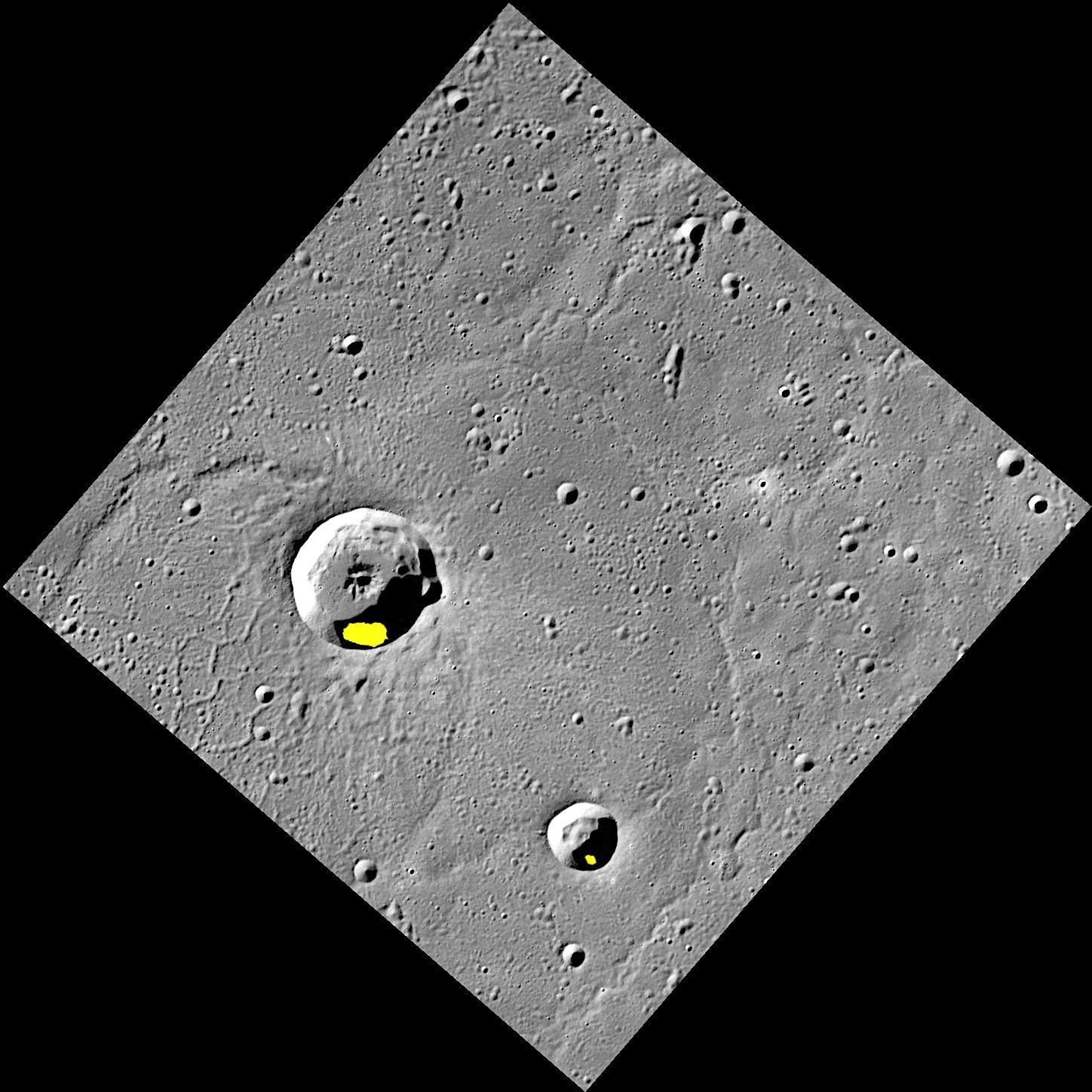
Possible Ice Deposits in Egonu and Monk Craters


Finding evidence for water ice on the planet closest to the Sun was an exciting discovery, but there is still more to learn about Mercury's icy deposits. Regions of permanent shadow seem to be a requirement for water ice to reside on the Solar System's innermost planet, so the large majority of Mercury's water ice deposits are located within impact craters at high latitudes. The two craters shown here, Egonu and Monk, both appear to have areas of permanent shadow and radar-bright deposits (shown in yellow) that are associated with water ice. However these craters are located a fair distance from Mercury's pole, all the way down at 66° latitude! How long can ice stay in these craters? That is just one of the interesting questions about Mercury's water ice deposits still being investigated.

This image was acquired as part of MDIS's high-resolution surface morphology base map. The surface morphology base map covers more than 99% of Mercury's surface with an average resolution of 200 meters/pixel. Images acquired for the surface morphology base map typically are obtained at off-vertical Sun angles (i.e., high incidence angles) and have visible shadows so as to reveal clearly the topographic form of geologic features.

Date acquired: July 20, 2011
Image Mission Elapsed Time (MET): 219648898
Image ID: 528063
Instrument: Wide Angle Camera (WAC) of the Mercury Dual Imaging System (MDIS)
WAC filter: 7 (748 nanometers)
Center Latitude: 67.29°
Center Longitude: 63.51° E
Resolution: 133 meters/pixel
Scale: Egonu has a diameter of 25 km (16 miles); Monk has a diameter of 13 km (8 miles)
Incidence Angle: 74.5°
Emission Angle: 0.2°
Phase Angle: 74.5°
Arecibo Radar Image: Shown in yellow, from Harmon et al., Icarus, 211, 37-50 (2011)

Image credit: NASA/Johns Hopkins University Applied Physics Laboratory/Carnegie Institution of Washington